- Select a language for the TTS:
- UK English Female
- UK English Male
- US English Female
- US English Male
- Australian Female
- Australian Male
- Language selected: (auto detect) - EN
Play all audios:
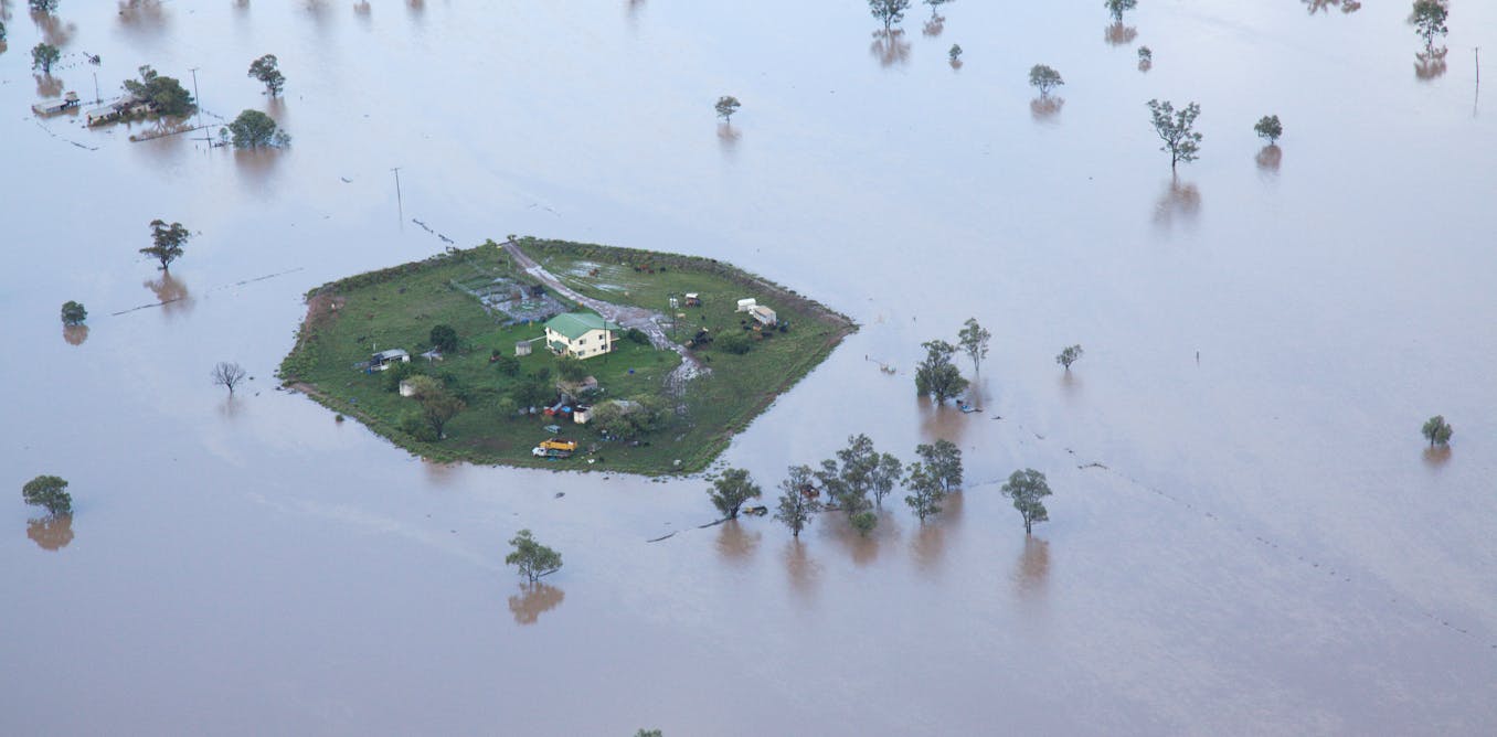
Recent wet weather and flooding across eastern Australia has caused many to ask, wasn’t climate change supposed to cause more droughts, not floods? Critics of climate change science have
suggested that the recent observed flooding shows the science, and especially the climate modelling, must be wrong. This is a misreading of what climate change scientists have repeatedly
stated. Such misunderstandings would not necessarily matter. But confusion has arisen from these claims, especially among decision-makers from flood-affected areas. These people have a
strong interest and responsibility to get the story right in order to make the right policy decisions. A LONG HISTORY OF PREDICTING INCREASED RISK OF BOTH FLOODS AND DROUGHTS Climate
scientists have been saying for a long time that one of the effects of climate change is likely to be more intense rainfall and flooding. In 1989, at a presentation to the Prime Minister’s
Science Council, Dr Graeme Pearman of CSIRO summarised a scenario of climate change for Australia in 2030. He said there would be: * higher summer rainfall over northern Australia and
extending further south. * possibly drier winters in southern Australia * more intense rainfall. CSIRO’s Climate Impact Group, in a report to the Northern Territory Government in 1992-93
wrote: “The above results suggest that wet season runoff may increase substantially by 2030 … the results strongly suggest that flood frequencies may increase significantly. If so, this
would have a major impact on the urban environment … built infrastructure, agriculture and hydrological planning, including the management of tailings dams and other sources of water
pollution.” Other reports to state governments contained similar conclusions. For example, CSIRO warned the NSW government in 1997-98 of “extreme daily rainfall intensity and frequency
increases in many regions, particularly in summer and autumn”. The Intergovernmental Panel on Climate Change (IPCC) has made similar remarks regarding the increase in heavy rain events for
Australia and other regions in its reports starting in 1990. THE MODELS GET BETTER, BUT THE RESULTS REMAIN SIMILAR In the 1980s and early 1990s climate modelling was in its infancy.
Scenarios of climate changes due to the enhanced greenhouse effect were based additionally on our understanding of basic physical laws, plus some reference to situations in the past with
similar climatic variations. There has been a gradual improvement of climate models and increase in computing power, going from simple energy balance models in one or two dimensions to fully
three-dimensional models with multi-layer oceans and atmospheres. This has included more detailed physics such as ocean currents and atmospheric circulation, clouds, and interactions with
the biosphere. Despite all these improvements, the general conclusions on a global scale have not changed significantly, although they now give more regional detail. As the climate models
improved - and as they were tested against real observed climatic variations such as the annual cycle and El Niño-La Niña cycles - they became more useful for making predictions about
specific regions. The models are still not perfect but are increasingly reliable if used within their acknowledged limitations. They enable us to establish broad directions and magnitudes of
change, with quantified degrees of uncertainty suitable for making decisions about how to quantify risk. WHAT MAKES IT RAIN? For Australia, several considerations will determine the actual
regional changes in a warmer climate. The first is the dominant synoptic weather patterns that lead to the natural distribution of floods and droughts in Australia. In the north,
high-intensity rainfall events are produced by: * convective storms over land when there are onshore winds containing lots of moisture * onshore winds crossing over mountain ranges, such as
the trade winds blowing westward over the Queensland coast * onshore westerlies associated with weather patterns in the Indian Ocean * tropical cyclones right across northern Australia * the
summer monsoon which affects all of northern Australia, but sometimes penetrates further south in the form of tropical lows. These are predominantly summer half-year phenomena and all will
likely become more intense as a result of global warming. This is simply because of more available moisture content in warmer air that has passed over warmer oceans, leading to more intense
convection. In the south, however, wet weather is dominated by low pressure systems and associated cold fronts which come from turbulence associated with the mid-latitude jet streams and low
pressure belt. Again, a warmer world will likely make rainfall from these systems more intense. However, models and the paleo-climate record indicate that these systems will be located
further polewards in general in a warmer world. This has been observed in recent decades. These systems produce rain over southern Australia predominantly in the colder months, so winter
rains in southern Australia are likely to be less frequent, with heavier rain occurring further south. This was summarised in a CSIRO-BoM set of projections in 2007: “Models show an increase
in daily precipitation intensity but also in the number of dry days. Extreme daily precipitation tends to increase in many areas but not in the south in winter and spring when there is a
strong decrease in mean precipitation.” DROUGHTS ARE ALSO LIKLY TO BE MORE INTENSE In situations where there are no rain-bearing systems - such as in winter in northern Australia and summer
in southern Australia - warmer conditions and a greater water-holding capacity of the air will lead to more rapid evaporation. This will lead to a more rapid onset of droughts, which will
become more intense. The combination of heavier rains followed by more rapid onset of drought will likely lead to lots of drying fuel for bushfires, which are likely to become more frequent
and intense. Another important factor is the behaviour of the El Niño and La Niña phenomena. These are hemispheric-scale systems that lead respectively to wetter or drier conditions over
northern and eastern Australia. Evidence from paleoclimatic records is that they both existed during past warmer and cooler periods. But how they might change under enhanced global warming
is still uncertain. Despite this uncertainty, when they do occur their effects on rainfall will be magnified by the warmer conditions, as we have seen in the last decade. A Special Climate
Statement from BoM in February 2012 summarised the real observed situation in 2010-2011 thus: “It was notable … that the bulk of the above average rainfall of the past two years fell during
the northern wet season … with tropical influenced weather systems bringing monsoonal-like rainfall to much of the continent. By contrast, dry conditions persisted during the 2010 and 2011
April to June period (the start of the early winter rainfall period) across southern Australia. … The high 2010 and 2011 rainfall was therefore not associated with winter-time storm systems,
and did not represent a return to normal conditions over the southern Australian winter season. In this way, the recent trend of rainfall reductions in autumn and winter was not reversed by
the back-to-back La Niña events.” So, basic physics and climate models both suggest that a warmer Earth will likely see both more intense droughts and floods over Australia, with some
regional differences. The succession of events in the last decade or so is consistent with this prognosis. What we should do about it, by way of prevention or adaptation, is a subject for
further discussion. It requires appropriate risk management. _For further information, please see the author’s 1992 and 1993 papers investigating climate change impacts on rainfall._


:max_bytes(150000):strip_icc():focal(599x0:601x2)/Sabrina-Impacciatore-White-Lotus-Racist-Cake-121622-1-288766a711fe4b3eb33710bd0f1b9606.jpg)