- Select a language for the TTS:
- UK English Female
- UK English Male
- US English Female
- US English Male
- Australian Female
- Australian Male
- Language selected: (auto detect) - EN
Play all audios:
In Derna, Libya, a record-breaking storm and subsequent dam failures on September 10, 2023, caused over 11,000 deaths. Analyzing satellite data from 2016–2023, we found 1.8 mm/yr of
differential settlement in dams contributed to their failure, and flooding damaged ~8570 buildings. We argue that the interplay of aging infrastructure, political instability, climate
change, and human decisions drove this disaster, stressing the need for a holistic ‘healthcare’ management approach to prevent future catastrophes. In the northeastern Libyan city of Derna,
Storm Daniel1, a mid-latitude cyclone that exhibited characteristics of tropical cyclones2,3,4, caused a record-breaking precipitation event on September 10, 2023, with up to 400 millimeters
of rain falling in just 24 h5. This extreme weather event caused a massive flood that washed away two embankment dams built to protect Derna against floods: the 75-meter-high Bu Mansour dam
and the 40-meter-high Elbilad dam1 (Fig. 1). The Bu Mansour dam was designed to withstand rare flood events and protect the city6. The collapse of these dams unleashed approximately 30
million cubic meters of water, destroying many buildings in Derna with a death toll of more than 11,000, and many more missing and homeless5. The United Nations highlighted that most
casualties could have been avoided if proper early warning and emergency management systems had been operational7. Here, we leverage the entire archive of the synthetic aperture radar (SAR)
data collected by Sentinel-1 satellites to detect slow but steady land settlement over the city of Derna and its infrastructures, including the dams. We further apply a Bayesian image
classification to identify buildings damaged during the flood event. We discuss how the compounding effect of aging dams, political instability, climate change, and poor human decisions
turned a hazard into a human disaster, where consecutive hazards with spatial and temporal overlapping impacts affect the dynamic vulnerability of a community, creating a disaster with
devastating human consequences8,9,10. SUBSIDENCE: TELLTALE SIGN OF AGING DAMS Both failed dams in Libya were over 50 years old and had been reported to suffer from significant structural
issues and inadequate maintenance6,11. Signs of defects and cracks in these aging dams were first reported in 1998. Among other defects, differential settlement in an aging dam often
indicates an underlying issue within the body or foundation of the dam12. Differential settlement refers to unevenly settling a structure’s foundation, where different parts sink at varying
rates. This phenomenon can occur due to various factors such as soil conditions, load distribution, and structural integrity. If not adequately mitigated, excessive and uncontrolled
differential settlement can significantly jeopardize the integrity of a structure13,14, potentially leading to dam collapse. Here, we used satellite imagery to demonstrate that these dams
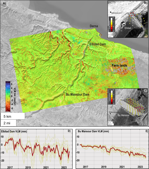
have experienced substantial differential settlement over the past 8 years, suggesting that the disaster was likely decades in the making (Fig. 1A–E). To create a surface deformation map, we
tracked the temporal change in the interferometric phase of each pixel on the ground. Assuming the principal deformation is vertical, we projected the line-of-sight measurements in the
vertical direction to obtain vertical land motions (VLM). The VLM map indicates widespread subsidence (i.e., negative VLM) affected the city of Derna and its surroundings (Fig. 1A). The
entire city subsides at an average rate of −0.7 mm/yr with a maximum subsidence rate of −5.8 ± 0.07 mm/yr affecting the city’s flood protection infrastructure (Supplementary Fig. S5) due to
the compaction of coastal sediments. Thus, the local sea level rise (i.e., the difference between land elevation and sea surface) rate that Derna experiences is nearly double the global
average, amplifying extreme water levels due to storm surges. The farmlands to the city’s southeast (marked in Fig. 1A) also experience maximum subsidence of −5.7 ± 0.05 mm/yr. In this
semi-arid region, overexploitation of groundwater resources for irrigation has stressed aquifer systems15, causing their compaction to manifest as land subsidence. Our dataset offers
exceptional spatial resolution (~15 m), enabling us to investigate the settlement of individual buildings and infrastructure, such as the failed embankment dams, in the years leading up to
the disaster. As observed, both dams have undergone differential subsidence with respect to the adjacent lands. The Bu Mansour dam, on average, subsided at a rate of −1.8 mm/yr with a
maximum rate of −2.2 ± 0.05 mm/yr, while the Elbilad dam subsided at an average rate of −1.7 mm/yr and a maximum rate of −2.3 ± 0.05 mm/yr. These differential settlements from 2016 to 2023
resulted in an angular distortion up to 3.6 × 10⁻⁴ (0.021°) and 5.0 × 10⁻⁴ (0.029°), respectively. If accumulated over a decade or more, these distortions can compromise the infrastructure,
posing a risk to the structural integrity of any dam. More broadly, they indicate poor maintenance and neglect of these structures, in addition to age and possible damage during past
floods11. POLITICAL INSTABILITY FUELS INFRASTRUCTURE NEGLECT: LEADING TO TRAGEDY Political instability poses significant challenges to infrastructure maintenance, which may have been a
critical factor contributing to the catastrophic dam failure in Libya. Dams, like all infrastructure, require continuous monitoring and periodic retrofitting to ensure safe operation16.
Proper maintenance and monitoring are essential as the dam ages, and its condition inevitably deteriorates. The Libya disaster is attributed to political instability leading to improper
infrastructure maintenance17, to the extent that some experts call for international investigation18, highlighting the detrimental effects of governance issues on infrastructure upkeep.
Regime changes and the lack of coordination between rival authorities have amplified the infrastructure crisis as essential services, including dam maintenance, suffered neglect19. Under
such circumstances, it is not unusual to observe that funds meant for critical upkeep were diverted for other purposes, leaving the dams to wither under the relentless force of time and
weather. Furthermore, the management and governance of critical infrastructure can become politicized, with decision-making processes influenced by political interests rather than purely
technical or environmental considerations. For instance, despite the establishment of a $335 million fund by the Tripoli-based Government of National Unity in 2021 for the rehabilitation of
Derna and Benghazi, these funds became entangled in political disputes, exacerbating challenges related to the cities’ recovery, including the upkeep of the dams19. Also, political
instability exacerbates disaster impacts by affecting dynamic vulnerability and generating spatiotemporally variable susceptibility to hazards9. For instance, in politically unstable
regions, neglect of healthcare facilities leaves communities more susceptible to disasters, limiting their ability to respond effectively when hazards occur. Political instability also
intensifies vulnerabilities by restricting economic opportunities, increasing poverty rates, and causing displacement, all of which compound the risk when disasters strike. The cyclical
nature of these vulnerabilities magnifies the impact of disasters, turning hazards into large-scale crises that are challenging to manage and recover from ref. 9. HUMAN DECISION TO SETTLE IN
FLOODPLAINS: A PRELUDE TO TRAGEDY In recent decades, human settlements have continuously grown within floodplains and flood-prone zones globally20. This human decision, a prelude to the
Libya tragedy, can set the stage for human disaster21. Derna, located on the northeastern shore of Libya, is a strategic city inhabited since the early days of human civilization22. The
Derna’s old city developed rapidly under Greek, Roman, and Ottoman rule within the Wadi Derna River valley, a floodplain, becoming a trade and culture center22. The appeal of fertile plains
and proximity to water sources proved irresistible to developers and settlers23,24,25. Consequently, cities and towns emerged along riverbanks and low-lying areas, often unaware of the
potential dangers. In the 20th century, following Italian occupation, the modern city emerged and proliferated after Libya’s independence in 1943, albeit without proper city planning22.
Following the Arab Spring in 2010, a large population immigrated to Derna, residing in the old city. We investigated the extent of damage sustained by buildings during the Libya catastrophe,
an indicator of human and economic loss. Our results reveal that more than 8570 buildings are damaged with >99% probabilities (Fig. 2). Areas with a high probability of damage are
located within the Wadi Derna River valley, a floodplain comprising the old city, where post-event optical imageries26 also show significant damage and thus poorly planned urbanization and
rapid expansion have inevitably encroached22,27. Thus, the lack of foresight in floodplain development is pivotal in the unfolding disaster, although this is a widespread problem. DISCUSSION
AND CONCLUSIONS Our analysis indicates significant differential settlement at the dam sites, exacerbated by poor maintenance and political instability. The resulting structural weaknesses
highlight a critical area where improved preparedness could make a difference. As discussed below, regular maintenance schedules, supported by political stability and adequate funding, are
crucial for preventing such failures. Additionally, enhancing community resilience through education, early warning systems, and robust emergency response plans could mitigate the human toll
of such disasters. These measures would empower communities to better cope with and recover from similar events in the future. The aftermath of Libya’s disaster offers valuable lessons for
improving preparedness and community resilience to withstand, adapt to, and recover from disasters, which are critical components of disaster risk reduction28,29,30. These concepts involve
the capacity of communities to anticipate, prepare for, respond to, and recover from adverse events. Understanding how these elements could have altered the outcome is essential in the
context of the Libya disaster. As illustrated in Fig. 3, the tragic flood event in Libya is a poignant example of the confluence of multiple factors, including development in floodplains,
political instability, inadequate infrastructure maintenance and management, and the specter of climate change, whose compounding effect can amplify the disaster. Libya’s catastrophe serves
as the most recent focal point in a larger landscape of neglect, as there are many other places, such as Afghanistan, Iraq, Syria, and Ukraine, where recent wars or political instabilities
have diverted attention away from critical infrastructure, especially its maintenance. As Fig. 3 illustrates, several other major dams with extensive downstream development are located in
regions where dam failure can rapidly lead to a human disaster. Disaster outcomes are profoundly shaped by vulnerability, emphasizing that disasters are not simply “natural” occurrences but
are often the result of underlying social, economic, and political factors. Disasters are disproportionately severe for communities with pre-existing vulnerabilities, such as poverty, weak
infrastructure, and limited resource access, which hinder effective disaster response and recovery31. As such, disasters are human-made in terms of their impacts, as hazard risks escalate
when communities lack the resources or resilience to withstand, adapt to, and recover from them32,33. Vulnerability turns hazards into disasters by exacerbating exposure and reducing the
capacity to respond effectively34. This perspective underscores that addressing vulnerabilities, ensuring equitable access to resources, and strengthening community resilience is essential
to mitigating disaster impacts and promoting more resilient societies. The flooding disaster in Derna, Libya, exemplifies the devastating impact of multi-hazard risks and consecutive
hazards, particularly when previous events like land subsidence, political instability, and infrastructure mismanagements have compromised vital structures. Overlapping and consecutive
disasters pose compounded challenges, often exceeding the capacity of systems designed to withstand isolated events8,10. Derna’s dams, initially constructed to shield the community from
floods, were gradually weakened by ongoing subsidence and insufficient maintenance due to a lack of recovery investments to enhance their resilience. This failure to address structural
vulnerabilities made the dams increasingly susceptible to subsequent hazards, such as heavy rainfall, ultimately leading to catastrophic flooding. Thus, the risk of exposure to future
hazards is exacerbated without sustained recovery efforts that reinforce infrastructure against multiple threats. While political instability can cause infrastructure mismanagement, some
stable countries, such as the United States, face substantial infrastructure challenges, too. The American Society of Civil Engineers’ 2021 report card rated U.S. infrastructure—covering
airports, schools, roads, bridges, dams, and levees—as mostly in “mediocre” or “poor” condition, with only railways achieving a “good” rating35. This was followed by a 2022 report that noted
that “public investment in U.S. infrastructure as a share of GDP has fallen by more than 40 percent since the 1960s,” leading to deteriorating roads, bridges, and public transit systems36.
In contrast to the U.S., Singapore, a developed country, consistently ranks highly in global infrastructure quality, mainly due to its strategic planning, sustained investment, and a strong
focus on maintenance. The government employs a forward-thinking approach with long-term infrastructure planning initiatives, such as the Land Transport Authority’s “Land Transport Master
Plan,” which maps out developments decades in advance. Furthermore, Singapore allocates significant funding to ensure infrastructure upkeep and uses advanced technologies to monitor and
manage infrastructure in real time37. These examples illustrate that while political instability directly undermines infrastructure maintenance, political stability alone does not guarantee
well-maintained infrastructure. Effective governance, consistent investment, and prioritization are crucial to ensure the longevity and safety of infrastructure systems. As the world
grapples with the consequences of a changing climate, Libya, too, felt the impacts of erratic and unexpected weather extremes4. The unusually intense precipitation event due to Storm Daniel4
may be attributed, in part, to a warming atmosphere with a higher capacity to hold moisture, as suggested for other events worldwide38,39. A recent site-specific study clergy showed that
the devastating storm that caused the flooding in Libya was made significantly more likely and intense due to human-caused climate change40. Their findings suggest that the storm was up to
50 times more likely to occur and 50% more intense because of the current levels of global warming. Ground-based observations and future projections indicate that the frequency and severity
of such extreme precipitation events have increased and are expected to rise further41,42. This heightened frequency and intensity of extreme precipitation43 events are a stark reminder of
the urgent need for adaptive measures in the face of this rapidly changing climate worldwide. Urban planning must address the rising risks of development in flood-prone areas by prioritizing
flood adaptation and mitigation strategies. This involves investing in resilient infrastructure that can withstand and quickly recover from disasters. Additionally, promoting public
awareness and education on flood risks and the importance of individual and community preparedness is essential. Derna’s old city, encompassing mainly 1–2 story buildings, is located within
the Wadi Derna River valley and is home to large immigrant communities that moved to Derna following the revolution. Due to a lack of funding and generally poor population and despite its
cultural and historical importance, the old city lacked essential flood protection and adaptation plans22 and thus was extensively damaged during the flood event27 with major loss of life.
The current holistic approaches for critical infrastructure protection44,45,46 focus mainly on preparation for, protection against, and response to infrastructure disruption. To avert such
catastrophes in the future, we believe more efforts should focus on infrastructure ‘health’ monitoring, considering pre-existing conditions and future climate to prevent infrastructure
failure from becoming a human disaster. This requires continuous screening and several diagnostic and treatment stages, ranging from minor repairs to major infrastructure retrofits. In some
cases, managed removal of critical infrastructure due to flawed design6 or a design incompatible with the operational requirements under expected future climate scenarios may be necessary.
Additionally, investment in research and development to better understand potential threats to infrastructure and develop innovative solutions to emerging, complex, and interconnected
challenges is a crucial component of such a holistic preventative approach. Although Bu Mansour Dam was intended to withstand rare hydrological events6, its design did not consider the
unprecedented rainfall of Storm Daniel. Derna’s disaster is the culmination of years of governance instability and political discourse23. Many countries do not have the resources, political
stability, or human capacity to address such challenges. For this reason, there is a need for an international service similar to the World Meteorological Organization (WMO) or World Climate
Research Programme (WCRP) that continuously monitors infrastructure health and generates early warnings for at-risk communities. Climate extremes will likely increase, with developing
countries bearing the worst impacts. Concerted international efforts can assist these countries in becoming more resilient in the face of climate change, and design guidelines and risk
assessment methods should be updated to account for the expected changing risks. This study underscores the importance of integrating preparedness and community resilience into disaster risk
management strategies. The findings highlight how various factors contributed to the Libya disaster and suggest that a holistic approach, encompassing regular infrastructure maintenance,
political stability, and community engagement, is vital for mitigating future risks. Future research should continue to explore these connections, providing a more comprehensive
understanding of how to enhance resilience and preparedness in vulnerable regions. Community engagement is a crucial component of effective disaster risk management, as it empowers local
populations to take an active role in preparedness and response efforts. Involving communities in risk assessment, early warning dissemination, and response planning increases awareness and
fosters a sense of shared responsibility for resilience. Previous studies47,48 have shown that communities engaged in preparedness and decision-making are better equipped to respond to and
recover from disasters. Incorporating community perspectives, resources, and knowledge into resilience strategies can strengthen overall preparedness and foster adaptive, sustainable
practices that align with local needs and conditions.” METHODS SAR INTERFEROMETRIC DEFORMATION ANALYSIS To generate high-resolution maps of surface deformation over the city of Derna, Libya,
we applied Wavelet-based InSAR (WabInSAR) algorithm, an advanced multitemporal interferometric synthetic aperture radar (InSAR) processing framework to 214 SAR images acquired in ascending
orbit of Sentinel-1 A/B satellites, during 2016/06/08-2023/09/12. We first generated a large set of high-quality Interferograms using GAMMA software49. We applied a multi-looking factor of 6
by 1 in the range and azimuth direction to improve the signal-to-noise ratio and obtain an average ground resolution of ~15 m × ~15 m. We discarded distributed scatterers with coherence
less than 0.65 and permanent scatterers with amplitude dispersion of more than 0.3, following the approach detailed in ref. 50. Next, we employed a minimum cost flow phase unwrapping
algorithm modified to be applied to a sparse set of less noisy pixels to estimate absolute phase changes in each interferogram. We corrected all unwrapped interferograms for the effect of
orbital error51 and reduced the effects of topographically correlated atmospheric phase delay and spatially uncorrelated DEM error52,53. To estimate each pixel’s line-of-sight (LOS) time
series and velocity, we applied a reweighted least-squares optimization53. Assuming that the principal deformation is vertical, we used the satellite unit vectors54 and projected the LOS in
the vertical direction. To transform the InSAR-based vertical land motion (VLM) to the IGS14 global reference frame, we utilized the global VLM model generated by Hammond et al.55, which
mainly includes long-wavelength deformation signals due to glacial isostatic adjustment, tectonics, and total water storage changes in a global reference frame, and applied an affine
transformation following13,56. Supplementary Fig. 1 shows the LOS velocity map with respect to a local reference point (Lon: 22.5206°, Lat: 32.6708°), and associated standard deviation and
local incidence angles are shown in Supplementary Figs. 2 and 3. Supplementary Fig. 4 shows the spatial distribution of VLM in a local reference frame as a result of dividing the LOS
velocity of each pixel by the cosine of the associated incidence angle. Figure 1 shows the VLM map in the IGS14 reference frame. Supplementary Fig. 5 is a closeup map showing the subsidence
at some coastal infrastructure, particularly the Derna’s seawalls, where a subsidence rate of up to −5.8 mm/yr is observed. BUILDING DAMAGE PROBABILITY To generate a probabilistic map of
building damage for the city of Dena, we use interferometric phase coherence of two interferograms spanning the pre-flood period 2023/08/07–2023/08/19 and the co-flood period
2023/08/19–2023/09/12 and apply a Bayesian image segmentation framework57,58. We also used the building footprint provided by Google Research. Supplementary Fig. 6A, C show buildings
color-coded to their pre- and co-flood coherence. To this end, we identified the nearest pixel to the center of each building and assigned its coherence value to it. Given the
interferometric phase coherence (_ρ_°) of each building, the conditional probability of being damaged, _p_(_D_/_ρ__ο_), is estimated as following: $$p(D/{\rho }^{{\rm{o}}})=\frac{p({\rho
}^{{\rm{o}}}/D)p(D)}{p({\rho }^{{\rm{o}}})}$$ (1) $$p({\rho }^{0})=p({\rho }^{0}/D)p(D)+p({\rho }^{0}/{\bar{D}})p({\bar{D}})$$ (2) where \(p\left({\rho }^{{\rm{o}}}/D\right)\) is the
probability of recording a given coherence value _ρ_ο for damaged building (_D_), \(p({\rho }^{0}/\bar{D})\) is the probability of recording a given coherence value _ρ_ο for a non-damaged
building (\(\bar{D}\)). Supplementary Fig. 6B, D show the histogram of the coherence of the buildings before and after damage used to estimate \(p\left({\rho }^{{\rm{o}}}/D\right)\) and
\(p({\rho }^{0}/\bar{D})\). Also, _p_(_ρ_0) is the marginal probability of recording a given coherence value _ρ__ο_ for any building. The terms _p_(_D_) and \(p(\bar{D})\) are the prior
probabilities of a building being damaged and non-damaged. In a Bayesian framework, _p_(_D_) represents the prior probability of damaged building, prior to the coherence being measured, and
\(p(\bar{D})\) = 1 _− p_(_D_). We choose a noninformative prior as _p_(_D_) = \(p(\bar{D})\) = 0.5, namely, the initial chance of a building being damaged is the same as not being damaged.
We tested different values and found that the posterior probability distribution of damaged buildings depends weakly on the choice of prior values. Supplementary Fig. 7 shows buildings
color-coded according to their probability of being damaged. DISTORTION ANGLE In geotechnical engineering, the angular change in relative elevation of two adjacent points, so-called angular
distortion, is widely used to indicate infrastructure damage due to differential settlement13,59,60. Given two observation points apart by horizontal distance _l_ and settlements of δ1 and
δ2, the angular distortion, _β_ is given by Eq. ((3)): $$\beta =\frac{{\delta }_{2}-{\delta }_{1}}{l}$$ (3) Depending on the type of materials, a range of _β_ is suggested as an indicator
for negligible to severe infrastructure damage due to differential subsidence. For instance, Wood et al.61 reported cracks and damage to brick walls and encased steel frames for a _β_ of
1/1000 to 1/100. Also, _β_ greater than 6.6/1000 is associated with structural damage in beams and columns, and _β_ larger than 3.3/1000 can cause cracking in structures with steel or
reinforced concrete frames14. DATA AVAILABILITY No datasets were generated or analyzed during the current study. REFERENCES * Petley, D. _The failed dams in Wadi Derna in Libya_ (EOS, 2023).
* Miglietta, M. M. & Rotunno, R. Development mechanisms for Mediterranean tropical-like cyclones (medicanes). _Q. J. R. Meteorological Soc._ 145, 1444–1460 (2019). Article Google
Scholar * Cavicchia, L., von Storch, H. & Gualdi, S. A long-term climatology of medicanes. _Clim. Dyn._ 43, 1183–1195 (2014). Article Google Scholar * Fowler, H. J., Blenkinsop, S.,
Green, A. & Davies, P. A. Precipitation extremes in 2023. _Nat. Rev. Earth Environ._ 5, https://doi.org/10.1038/s43017-024-00547-9 (2024). * Qiu, J., Zhao, W., Brocca, L. & Tarolli,
P. Storm Daniel revealed the fragility of the Mediterranean region. _Innov. Geosci._ 1, 100036 (2023). Article Google Scholar * Ashoor, A. & Eladawy, A. Navigating catastrophe: lessons
from Derna amid intensified flash floods in the Anthropocene. _Euro Mediterr. J. Environ. Integr._, 9, 1125–1140 (2024). * UN: Most Flood Casualties in Libya Could Have Been Avoided. Voice
of America, 14 September 2023, https://www.voaafrica.com/a/un-most-flood-casualties-in-libya-could-have-been-avoided/7267984.html. (Agence France-Presse, 2023). * Mohammadi, S., De Angeli,
S., Boni, G., Pirlone, F. & Cattari, S. Current approaches and critical issues in multi-risk recovery planning of urban areas exposed to natural hazards. _Nat. Hazards Earth Syst. Sci._
24, 79–107 (2024). Article Google Scholar * de Ruiter, M. C. & Van Loon, A. F. The challenges of dynamic vulnerability and how to assess it. _IScience_ 25, 104720 (2022). * De Ruiter,
M. C. et al. Why we can no longer ignore consecutive disasters. _Earths. Future_ 8, e2019EF001425 (2020). Article Google Scholar * Ashoor, A. Estimation of the surface runoff depth of Wadi
Derna Basin by integrating the geographic information systems and Soil Conservation Service (SCS-CN) model. _J. Pure Appl Sci._ 21, 90–100 (2022). Google Scholar * Dixon, T. H. et al.
Space geodesy: Subsidence and flooding in New Orleans. _Nature_ 441, 587–588 (2006). Article CAS Google Scholar * Ohenhen, L. & Shirzaei, M. Land Subsidence Hazard and Building
Collapse Risk in the Coastal City of Lagos, West Africa. _Earths Future_ 10, e2022EF003219 (2022). Article CAS Google Scholar * Day, R. W. Differential movement of slab-on-grade
structures. _J. Perform. Constructed Facilities_ 4, 236–241 (1990). Article Google Scholar * Wheida, E. & Verhoeven, R. Review and assessment of water resources in Libya. _Water Int._
31, 295–309 (2006). Article Google Scholar * Perera, D., Smakhtin, V., Williams, S., North, T. & Curry, A. Ageing water storage infrastructure: An emerging global risk. _UNU-INWEH Rep.
Ser._ 11, 25 (2021). Google Scholar * Libya Floods: Causes and Implications. Defender Center for Human Rights. Retrieved November 4, 2024, from
https://defendercenter.org/ar/7181?fbclid=IwAR3rdQkis6-C0cWt_u59zdTdXTAttDefb7K113NEfY0tTnZguLBql8YXN4g. (Defender Center, 2023). * Libya: Derna Flood Response Costs Lives. Human Rights
Watch. Retrieved November 4, 2024, from https://www.hrw.org/news/2023/12/06/libya-derna-flood-response-costs-lives (Human Rights Watch, 2023). * Boukhars, A. Libya’s Floods Are a Catastrophe
of the Country’s Own Making. Carnegie Endowment for International Peace. Retrieved November 4, 2024, from https://carnegieendowment.org/sada/90695 (2023). * Rentschler, J. et al. Global
evidence of rapid urban growth in flood zones since 1985. _Nature_ 622, 87–92 (2023). Article CAS Google Scholar * Devitt, L., Neal, J., Coxon, G., Savage, J. & Wagener, T. Flood
hazard potential reveals global floodplain settlement patterns. _Nat. Commun._ 14, 2801 (2023). Article CAS Google Scholar * Sasi, E. A. _Urban predicaments in Derna city_, İstanbul
Kültür Üniversitesi/Fen Bilimleri Enstitüsü/Mimarlık Anabilim Dalı, (2007). * Du, L., Peng, X. & Wang, F. City walking-trace: How watershed structure and river network changes influenced
the distribution of cities in the northern part of the North China Plain. _Quat. Int._ 521, 54–65 (2019). Article Google Scholar * Altaweel, M. Southern Mesopotamia: Water and the rise of
urbanism. _Wiley Interdiscip. Rev. Water_ 6, e1362 (2019). Article Google Scholar * Kondolf, G. M. & Pinto, P. J. The social connectivity of urban rivers. _Geomorphology_ 277, 182–196
(2017). Article Google Scholar * Storm Aftermath in Derna, Libya. NASA. Retrieved November 4, 2024, from https://earthobservatory.nasa.gov/images/151851/storm-aftermath-in-derna-libya.
(NASA Earth Observatory, 2023). * Hanson, K. B. et al. Flood Damage to the Old City of Derna, Libya. _Office of International Relations. Online resource_.
https://doi.org/10.25573/data.24216483.v1 (2023). * Adekola, J., Fischbacher-Smith, D. & Fischbacher-Smith, M. Inherent complexities of a multi-stakeholder approach to building community
resilience. _Int. J. Disaster Risk Sci._ 11, 32–45 (2020). Article Google Scholar * Robertson, T., Docherty, P., Millar, F., Ruck, A. & Engstrom, S. Theory and practice of building
community resilience to extreme events. _Int. J. Disaster Risk Reduct._ 59, 102253 (2021). Article Google Scholar * Jones, L. Resilience isn’t the same for all: Comparing subjective and
objective approaches to resilience measurement. _Wiley Interdiscip. Rev. Clim. Change_ 10, e552 (2019). Article Google Scholar * 5 Reasons Why Disasters Are Not Natural. United Nations
University Institute for Environment and Human Security. Retrieved November 7, 2024, from https://unu.edu/ehs/series/5-reasons-why-disasters-are-not-natural. (United Nations University,
2020). * No Natural Disasters Campaign. UNDRR. Retrieved November 7, 2024, from https://www.undrr.org/our-impact/campaigns/no-natural-disasters. (United Nations Office for Disaster Risk
Reduction). * Natural Disasters Do Not Exist. PreventionWeb. Retrieved November 7, 2024, from https://www.preventionweb.net/hubs/risk-media-hub/natural-disasters-do-not-exist.
(PreventionWeb). * There’s No Such Thing as a Natural Disaster. No Natural Disasters. Retrieved November 7, 2024, https://www.nonaturaldisasters.com/. * ASCE Infrastructure Report Card.
http://www.infrastructurereportcard.org/. [Accessed 12 December 2022]. (2021). * The Time is Now to Modernize U.S. Infrastructure. The White House. Retrieved November 4, 2024, from
https://www.whitehouse.gov/cea/written-materials/2021/11/15/the-time-is-now-to-modernize-u-s-infrastructure/. (Council of Economic Advisers, 2021). * Land Transport Master Plan 2040:
Bringing Singapore Together. Ministry of Transport. Retrieved from https://www.mot.gov.sg/. (Ministry of Transport Singapore, 2019). * Huang, X. & Swain, D. L. Climate change is
increasing the risk of a California megaflood. _Sci. Adv._ 8, eabq0995 (2022). Article Google Scholar * Swain, D. L., Singh, D., Touma, D. & Diffenbaugh, N. S. Attributing extreme
events to climate change: A new frontier in a warming world. _One Earth_ 2, 522–527 (2020). Article Google Scholar * Kirka, D. Scientists say Libya’s deadly floods showed climate risks,
need for warning systems. AP News. Retrieved November 4, 2024, from https://apnews.com/article/climate-change-libya-flood-study-3eda9e77840d8bbd7058e494cc0a2231 (2023). * Papalexiou, S. M.
& Montanari, A. Global and regional increase of precipitation extremes under global warming. _Water Resour. Res._ 55, 4901–4914 (2019). Article Google Scholar * Trenberth, K. E.
Changes in precipitation with climate change. _Clim. Res._ 47, 123–138 (2011). Article Google Scholar * Ragno, E. et al. Quantifying changes in future intensity-duration-frequency curves
using multimodel ensemble simulations. _Water Resour. Res._ 54, 1751–1764 (2018). Article Google Scholar * Nweke, L. O. & Wolthusen, S. D. A Holistic Approach for Enhancing Critical
Infrastructure Protection: Research Agenda. in _International Conference on Emerging Applications and Technologies for Industry 4.0 (EATI’2020) Emerging Applications and Technologies for
Industry 4.0_. 220–228 (Springer, 2021). * Laugé, A., Hernantes, J. & Sarriegi, J. M. Critical infrastructure dependencies: A holistic, dynamic and quantitative approach. _Int. J. Crit.
Infrastruct. Prot._ 8, 16–23 (2015). Article Google Scholar * Thomas, J. E., Eisenberg, D. A. & Seager, T. P. Holistic infrastructure resilience research requires multiple
perspectives, not just multiple disciplines. _Infrastructures_ 3, 30 (2018). Article Google Scholar * Paton, D. & Johnston, D. Disasters and communities: vulnerability, resilience and
preparedness. _Disaster Prev. Manag. Int. J._ 10, 270–277 (2001). Article Google Scholar * McEntire, D. A. _Disaster response and recovery: strategies and tactics for resilience_ (John
Wiley & Sons, 2021). * Werner, C., Wegmüller, U., Strozzi, T. & Wiesmann, A. Gamma SAR and interferometric processing software. in _Proceedings of the ers-envisat symposium_,
_Gothenburg, Sweden_. 1620 (Citeseer). * Lee, J.-C. & Shirzaei, M. Novel algorithms for pair and pixel selection and atmospheric error correction in multitemporal InSAR. _Remote Sens.
Environ._ 286, 113447 (2023). Article Google Scholar * Shirzaei, M. & Walter, T. R. Estimating the Effect of Satellite Orbital Error Using Wavelet-Based Robust Regression Applied to
InSAR Deformation Data. _IEEE Trans. Geosci. Remote Sens._ 49, 4600–4605 (2011). Article Google Scholar * Shirzaei, M. & Bürgmann, R. Topography correlated atmospheric delay correction
in radar interferometry using wavelet transforms. _Geophys. Res. Lett._ 39, https://doi.org/10.1029/2011GL049971 (2012). * Shirzaei, M. A Wavelet-Based Multitemporal DInSAR Algorithm for
Monitoring Ground Surface Motion. _IEEE Geosci. Remote Sens. Lett._ 10, 456–460 (2013). Article Google Scholar * Hanssen, R. F. _Radar interferometry, data interpretation and error
analysis_ (Kluwer Academic Publishers, 2001). * Hammond, W. C., Blewitt, G., Kreemer, C. & Nerem, R. S. GPS Imaging of Global Vertical Land Motion for Studies of Sea Level Rise. _J.
Geophys. Res. Solid Earth_ 126, e2021JB022355 (2021). Article Google Scholar * Blackwell, E., Shirzaei, M., Ojha, C. & Werth, S. Tracking California’s sinking coast from space:
Implications for relative sea-level rise. _Sci. Adv._ 6, eaba4551 (2020). Article Google Scholar * Sherpa, S. F. & Shirzaei, M. Country-wide flood exposure analysis using Sentinel-1
synthetic aperture radar data: Case study of 2019 Iran flood. _J. Flood Risk Manag._, 15, e12770 (2021). * Sherpa, S. F., Shirzaei, M., Ojha, C., Werth, S. & Hostache, R. Probabilistic
Mapping of August 2018 Flood of Kerala, India, Using Space-Borne Synthetic Aperture Radar. _IEEE J. Sel. Top. Appl. Earth Observations Remote Sens._ 13, 896–913 (2020). Article Google
Scholar * Burland, J. B. & Wroth, C. Settlement of buildings and associated damage. Settlement of buildings and associated damage, National Academies of Sciences, Engineering, and
Medicine (No. CP 33/75) (1975) . * Cigna, F. & Tapete, D. Present-day land subsidence rates, surface faulting hazard and risk in Mexico City with 2014–2020 Sentinel-1 IW InSAR. _Remote
Sens. Environ._ 253, 112161 (2021). Article Google Scholar * Wood, R. H. et al. Discussion. the stability of tall buildings. _Proc. Inst. Civ. Eng._ 12, 502–522 (1959). Google Scholar
Download references ACKNOWLEDGEMENTS A grant from DoD supported this research. The building footprint is provided by Google Research
(https://data.humdata.org/dataset/buildings-footprint-floods-derna-libya). European Space Agency, Sentinel-1 SAR images are obtained through Alaska Satellite Facilities at
https://asf.alaska.edu/. The InSAR deformation datasets and distortion angles generated in this study are available at https://doi.org/10.7294/25374619. AUTHOR INFORMATION AUTHORS AND
AFFILIATIONS * Virginia Tech, Department of Geosciences, Blacksburg, VA, USA Manoochehr Shirzaei, Nitheshnirmal Sadhasivam, Leonard Ohenhen, Oluwaseyi Dasho, Ashutosh Tiwari & Susanna
Werth * United Nations University, Institute for Water, Environment and Health, Richmond Hill, ON, Canada Manoochehr Shirzaei, Farshid Vahedifard & Amir AghaKouchak * Tufts University,
Department of Civil and Environmental Engineering, Medford, MA, USA Farshid Vahedifard & Mohammed Azhar * University of California, Department of Civil & Environmental Engineering,
Irvine, CA, USA Yunxia Zhao & Amir AghaKouchak * University of East Anglia, Tyndall Centre for Climate Change Research, Norwich, UK Robert J. Nicholls Authors * Manoochehr Shirzaei View
author publications You can also search for this author inPubMed Google Scholar * Farshid Vahedifard View author publications You can also search for this author inPubMed Google Scholar *
Nitheshnirmal Sadhasivam View author publications You can also search for this author inPubMed Google Scholar * Leonard Ohenhen View author publications You can also search for this author
inPubMed Google Scholar * Oluwaseyi Dasho View author publications You can also search for this author inPubMed Google Scholar * Ashutosh Tiwari View author publications You can also search
for this author inPubMed Google Scholar * Susanna Werth View author publications You can also search for this author inPubMed Google Scholar * Mohammed Azhar View author publications You can
also search for this author inPubMed Google Scholar * Yunxia Zhao View author publications You can also search for this author inPubMed Google Scholar * Robert J. Nicholls View author
publications You can also search for this author inPubMed Google Scholar * Amir AghaKouchak View author publications You can also search for this author inPubMed Google Scholar CONTRIBUTIONS
M.S. designed the study, performed the analysis, and wrote the first draft of the manuscript. F.V. contributed to the discussions and revised the manuscript. N.S. contributed to the
discussions and revised the manuscript, L.O. contributed to the discussions and revised the manuscript, O.D. contributed to the discussions and revised the manuscript, A.T. contributed to
the discussions and revised the manuscript, S.W. contributed to the discussions and revised the manuscript, M.A. contributed to the discussions and revised the manuscript, Y.Z. contributed
to the discussions and revised the manuscript, R.N. contributed to the discussions and revised the manuscript, and A.A. contributed to the discussions and revised the manuscript. All authors
have read and approved the manuscript. CORRESPONDING AUTHOR Correspondence to Manoochehr Shirzaei. ETHICS DECLARATIONS COMPETING INTERESTS The authors declare no competing interests.
ADDITIONAL INFORMATION PUBLISHER’S NOTE Springer Nature remains neutral with regard to jurisdictional claims in published maps and institutional affiliations. SUPPLEMENTARY INFORMATION
SUPPLEMENTARY MATERIALS RIGHTS AND PERMISSIONS OPEN ACCESS This article is licensed under a Creative Commons Attribution-NonCommercial-NoDerivatives 4.0 International License, which permits
any non-commercial use, sharing, distribution and reproduction in any medium or format, as long as you give appropriate credit to the original author(s) and the source, provide a link to the
Creative Commons licence, and indicate if you modified the licensed material. You do not have permission under this licence to share adapted material derived from this article or parts of
it. The images or other third party material in this article are included in the article’s Creative Commons licence, unless indicated otherwise in a credit line to the material. If material
is not included in the article’s Creative Commons licence and your intended use is not permitted by statutory regulation or exceeds the permitted use, you will need to obtain permission
directly from the copyright holder. To view a copy of this licence, visit http://creativecommons.org/licenses/by-nc-nd/4.0/. Reprints and permissions ABOUT THIS ARTICLE CITE THIS ARTICLE
Shirzaei, M., Vahedifard, F., Sadhasivam, N. _et al._ Aging dams, political instability, poor human decisions and climate change: recipe for human disaster. _npj Nat. Hazards_ 2, 5 (2025).
https://doi.org/10.1038/s44304-024-00056-1 Download citation * Received: 24 March 2024 * Accepted: 20 December 2024 * Published: 16 January 2025 * DOI:
https://doi.org/10.1038/s44304-024-00056-1 SHARE THIS ARTICLE Anyone you share the following link with will be able to read this content: Get shareable link Sorry, a shareable link is not
currently available for this article. Copy to clipboard Provided by the Springer Nature SharedIt content-sharing initiative