- Select a language for the TTS:
- UK English Female
- UK English Male
- US English Female
- US English Male
- Australian Female
- Australian Male
- Language selected: (auto detect) - EN
Play all audios:
ABSTRACT Reconstructing early human colonization of the Balearic Islands in the western Mediterranean is challenging due to limited archaeological evidence. Current understanding places
human arrival ~4400 years ago. Here, U-series data from phreatic overgrowth on speleothems are combined with the discovery of a submerged bridge in Genovesa Cave that exhibits a distinctive
coloration band near its top. The band is at the same depth as the phreatic overgrowth on speleothems (−1.1 meters), both of which indicate a sea-level stillstand between ~6000 and ~5400
years ago. Integrating the bridge depth with a high-resolution Holocene sea-level curve for Mallorca and the dated phreatic overgrowth on speleothems level constrains the construction of the
bridge between ~6000 and ~5600 years ago. Subsequent sea-level rise flooded the archeological structure, ruling out later construction dates. This provides evidence for early human presence
on the island dating at least 5600 and possibly beyond ~6000 years ago. SIMILAR CONTENT BEING VIEWED BY OTHERS NEW EVIDENCE OF A ROMAN ROAD IN THE VENICE LAGOON (ITALY) BASED ON HIGH
RESOLUTION SEAFLOOR RECONSTRUCTION Article Open access 22 July 2021 A HIGH-RESOLUTION DIGITAL BATHYMETRIC ELEVATION MODEL DERIVED FROM ICESAT-2 FOR ADAM’S BRIDGE Article Open access 27 June
2024 USING ARCHAEOLOGICAL DATA FOR THE UNDERSTANDING OF LATE-HOLOCENE SEA OF GALILEE’S LEVEL FLUCTUATIONS Article Open access 13 June 2022 INTRODUCTION Mallorca, the main island of the
Balearic Archipelago, is the sixth largest in the Mediterranean Sea, yet it was among the last to be colonized1. An in-depth discussion concerning the earliest colonization of various
Mediterranean islands, including Mallorca, may be found in Cherry and Leppard1, Dawson2, and Simmons3. Despite extensive research on this topic, there has been considerable disagreement
about the timing of the earliest colonization of Mallorca. Radiocarbon dating of bone material excavated from Cova (Cave) de Moleta indicate human presence on the island as early as 7000
calibrated years before present (cal B.P.)4. Subsequent age determinations from findings in Cova de Canet, further extended the timeline, suggesting human occupation dating back to
approximately 9000 cal B.P.5. A series of publications6,7,8,9,10,11 revealed inconsistencies regarding the exact stratigraphic position and context of the dated bone (sample KBN-640d12) in
Cova de Moleta. Due to the overall poor preservation of the samples and the lack of clear and specific information on this particular radiocarbon-dated sample, Ramis and Alcover7 suggested
that the bone fragment, initially identified as human, might actually belong to _M. balearicus_, an endemic bovid. Consequently, this sample was considered not relevant for determining the
timing of the island’s colonization. Similarly, the radiocarbon dates from Cova de Canet were considered highly controversial because they originate from a charcoal layer that lacks clear
evidence of human activity7,8. Furthermore, in neither of these caves do the _M. balearicus_ bones show butchery marks, making it difficult to establish a clear link to contemporary human
presence2. Due to the aforementioned issues these early results were deemed unreliable1,8,13. Several studies have reevaluated most of the previously dated materials and supplemented them
with new radiocarbon dates obtained from charcoal, ash, and bones6,7,9,10. Based on these new results, there is now a consensus that the timeframe for earliest human settlement on the island
is between 4600 and 4200 cal B.P.14. Dawson2 presents a synthesis of the various lines of argument regarding arrival models in the Balearic islands that includes: (1) Early (~9000 cal
B.P.), (2) Intermediate (~7600 cal B.P.), and (3) Late (~5000 cal B.P.) arrival phases. The last two models suggest the existence of stable settlements, yet only the third one has been
deemed plausible in the local archeological literature7,8,14. While there has been a growing body of evidence revealing progressively earlier human settlements on many islands in the
Mediterranean basin, the timeline for the initial human colonization in Mallorca has seen relatively minor adjustments over the past decades8,15,16. The latest research suggests that this
colonization occurred approximately 4400 cal B.P., coinciding with the human-mediated extinction of _Myotragus balearicus_14. This conclusion is based on two radiocarbon ages, which provide
a relatively narrow time window of 350 years (_p_ > 90%) between the last documented _Myotragus_ bone (4581–4417 cal B.P.) and the first dated sheep bone (4417–4231 cal B.P.). However, it
remains challenging to confirm whether the ages of these paleontological remains represent the latest or the earliest such occurrences on the island. Subsequent field work may shed light on
this matter. Our study site is a submerged archeological structure in the Genovesa Cave (also known as Cova de’n Bessó; 39°31’32” N, 3°19’2” E), situated in the eastern part of Mallorca
(Fig. 1a, b). The cave hosts ceramic sherds and stone constructions. The latter includes a stone-paved path that connects the cave entrance to the first underground lake (Fig. 1d), a
cyclopean stone wall running parallel to the path, and an 8.62 m long17 and 0.5 m high stone walkway (hereafter referred as to bridge) oriented NE–SW (Fig. 1c, e, Supplementary Fig. 1,
Supplementary Table 1). This last structure was built across a lake by stacking large limestone breakdown blocks on top of each other, without the use of mortar or cement. The uppermost
layer comprises flat boulders of considerable size (Supplementary Fig. 1b). The largest stone measures 1.63 m in length and 0.6 m in width. Relative to the preindustrial (pre-1900 CE) sea
level, the bridge is submerged by 1.05 ± 0.1 m of water at its upper part (Figs. 1e, 2). However, at the time of its construction, it served as an access path to the only other dry chamber
in the cave (Sala de les Rates-pinyades, i.e., Bats Room), where pottery, tentatively attributed to the Naviform period (ca. 3550–3000 cal B.P.) was discovered18,19. The bridge structure was
inferred to have been built around the same period20. Here, we integrate uranium-series (U-series) age data acquired from phreatic overgrowth on speleothems and stalactite tips in Genovesa
and Drac caves, along with Late Holocene relative sea level (RSL) information available for Mallorca21. Additionally, we consider the presence of the bridge, the coloration mark on its upper
part, and the depths at which these respective features occur. This combined evidence contributes valuable insights to the ongoing debate surrounding the timing of human colonization on
Mallorca. RESULTS AND DISCUSSION SPELEOTHEMS AND SEA LEVEL Proxies for cave-based sea-level reconstructions include mineralogical (sediments, speleothems)22,23, archeological (fish tanks,
saltpans, submerged structures, etc.)24, and biological (borings, worm tubes, etc.)24 records. In the case of Genovesa Cave, a typical coastal karst feature situated <450 m from the
shoreline, both mineralogical and archeological records are present. Many of its well-decorated passages, galleries, and chambers are now flooded due to rising sea levels20. Because of the
cave’s proximity to the coast and the high permeability of the Upper Miocene host rock25, the hydraulic gradient is negligible (9 × 10⁻⁵ m /m) for such short distances (see Methods), and
thus the water table in the cave is, and was in the past, coincident with sea level26,27. During times of high sea level stillstands, when the cave was partly flooded, distinct encrustations
of calcite and aragonite accumulated over preexisting stalactites, forming the so-called phreatic overgrowths on speleothems28 (POS). This is a particularly useful proxy for precisely and
accurately reconstructing sea-level changes across various timescales21,29. Furthermore, ordinary stalactites, which form in cave passages above the water table and later become submerged as
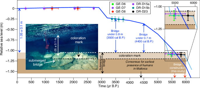
sea-levels rise are also valuable in this process since they document the moment when the cave shifted from being air- to water-filled22. A distinct light-colored band (~15 cm wide) is
visible along the entire bridge at its upper part (Fig. 2, Supplementary Fig. 1a). This coloration mark bears a resemblance to a “bathtub ring” and its presence is likely related to a
relatively short-lived stable water table that allowed the precipitation of a sub-millimeter calcite crust at the water/air interface. When the water level increased, the calcite did not
disappear since the water below the water table remained somewhat saturated with respect to calcium carbonate. As discussed later, this feature along with the new POS ages and their
elevation play a crucial role in determining when this bridge, now submerged, was constructed. GEOCHRONOLOGY The U-series ages (_n_ = 34; 28 for POS and 6 from stalactites) are given in
Supplementary Table 2 and are all reported as years before present (BP), where present is 1950 CE. Ten of these ages are from POS samples GE-D8 (Genovesa Cave; Supplementary Fig. 2) and
DR-D15 dated as part of a prior study21. The latter was collected in Drac Cave (39°32’9” N, 3°19’49” E), located 1.6 km to the north-east of Genovesa Cave (Fig. 1c, Supplementary Figs.
S3–S4). Regardless of the sampling depth, all the vadose stalactites on which the POS formed in both caves, produced ages older than 8200 years B.P. (Fig. 2, Supplementary Fig. 5). The
phreatic overgrowth samples GE-D6, GE-D7, and DR-D23 (Supplementary Figs. S6–S8), precipitated at ~1.10 ± 0.1 m below the preindustrial sea level (mbpsl). A 232Th/238U-234U/238U-230Th/238U
(plotted as a Rosholt A type) isochron age of 5479 ± 120 years B.P. (_n_ = 3 of 4; hereafter, ± refers to 2 σ uncertainty) was measured for GE-D6 (Supplemental Table 2, Supplementary Fig.
9a). GE-D7, in the same room and at the same elevation as GE-D6, yielded a weighted average age of 5510 ± 549 years B.P. using the same correction (initial 230Th/232Th atomic ratio = 5.1 ±
0.4 ppm) generated by the GE-D6 isochron age. Onac et al.21. used a slightly higher initial for GE-D8 (8 ppm) that was located at a higher elevation than GE-D6 & -D7. For DR-D23, we
obtained a 232Th/238U-234U/238U-230Th/238U (plotted as a Rosholt A type) isochron age of 5824 ± 140 years B.P. (_n_ = 6) (Supplementary Table 2, Supplementary Fig. 9b). This isochron shows
an exceptionally high initial 230Th/232Th atomic ratio = 527.5 ± 22.1 ppm, more than 10x higher than used for DR-D15 (44 ppm) from the same cave but at a different elevation21. The fluffy
fibrous cotton-candy texture of the two sub-samples with high U component of DR-D23 may have something to do with the high initial 230Th/232Th. The isochron ages were necessary to produce
accurate ages with smaller uncertainties. Collectively, the POS data from Genovesa and the nearby Drac, reveal three distinct periods of relative sea-level stability (Fig. 2). One occurred
at 0 ± 0.04 m from 2720 ± 11 to 296 ± 18 years B.P. The second period lasting from 3703 ± 14 to 3368 ± 8 years B.P., corresponds to a sea level of 0.25 mbpsl. Lastly, a third period at ~1.1
± 0.1 mbpsl is documented between 5820 ± 140 and 5479 ± 120 years B.P. (Figs. 2, 3). By adding the uncertainty to the older age and subtracting the uncertainty from the younger age, the
maximum time span of POS growth at 1.1 mbpsl ranges from 5964 – 5359 years B.P. During this interval, both the POS and the coloration mark formed. For the latter to develop, the bridge must
have been submerged, at least to its upper surface, allowing calcite to precipitate during the sea-level stillstand. Therefore, this period is of particular interest because it may aid in
providing the timeline of the bridge construction as detailed below. TIMING OF BRIDGE CONSTRUCTION The assembly date of the bridge in Genovesa Cave remains uncertain due to the absence of
written records or a robust time-stratigraphic context. In order to constrain the building time of this archeological structure, we rely on a well-defined Late Holocene sea-level curve
generated by Onac et al.21. for Mallorca (depicted by the solid blue line in Fig. 3) and the ages and depths at which POS grew and coloration mark formed. First, we assess previous
assumptions regarding the timing of the submerged bridge construction using this curve. Then, we examine our new sea-level data in conjunction with the timing of the earliest human arrival
model proposed by Bover et al.14. The prehistoric pottery discovered in Sala de les Rates-pinyades of the Genovesa Cave has been linked to the Naviform period (3550–3000 cal B.P.). This
attribution is based on typological similarities between the ceramics found in Genovesa and those documented at the Closos de Can Gaià, a Bronze Age site located ~10 km south of our cave
(Fig. 1b). The archeological horizon in which comparable pottery was discovered at the latter site was dated to ~3600 cal B.P30. However, Costa and Guerrero31 argue that Closos de Can Gaià
excavation required a reassessment of the chronological framework, due to issues with the radiocarbon dates. Despite this, adopting the previously reported radiocarbon age, Gràcia et al.20
suggested that the construction of the bridge likely occurred toward the end of the Naviform period. However, the RSL curve (Fig. 3) indicates that sea level was ~0.25 ± 0.1 m below the
preindustrial baseline ~3500 years ago21, implying a total water depth of ~1.3 m in the cave lake. The vertical height of the bridge is 0.5 m, and thus it was submerged by 0.8 m of water at
this time (Fig. 3). The construction of the bridge around 4400 years ago, the time suggested by Bover et al.14 to be the earliest evidence of human presence on the island, is also
improbable. At that time, relative sea level in Mallorca was ~0.35 ± 0.1 m below preindustrial level, and the bridge would have been submerged by 0.7 m. Building a bridge below water level
is a highly unlikely scenario, and thus it was likely built at an earlier time, when sea level was lower. The predicted relative sea-level curve for Mallorca (Fig. 3) indicates that the top
of the bridge would have been close to water level no earlier than 5600 years ago and this provides an approximate lower bound on the age of the feature. The distinct coloration mark on the
bridge also provides strong evidence of an age greater than the ages estimated by Gràcia et al.20 and Bover et al.14. As discussed earlier and according to the POS-based relative sea-level
record, this mark would not have developed if the top of the bridge was well below the water level, i.e., at times more recent than ~5500 years ago. However, an age older than 6000 years for
the feature can be ruled out since sea level was even lower (Fig. 3), and the construction of a bridge at its current height would have been unnecessary. The phreatic overgrowths GE-D6,
GE-D7, and DR-D23 from Genovesa and Drac caves formed at a relative sea level of 1.1 mbpsl, which is 5 cm below the upper part of the bridge. The two more precise isochron ages suggest
sea-level remained relatively constant for a few hundreds of years between ~5964 and 5359 years B.P. The relative brevity of this time frame might explain why the morphology and size of the
POS are somehow atypical and smaller compared to those POS that developed when the sea level was stable at 0 m for over 2000 years. Furthermore, this <600 year period of nearly constant
sea level was sufficient to develop the coloration mark. Given that the occurrence of this feature correlates directly with the previously mentioned sea-level stillstand position, it
suggests that the bridge was already in place. In fact, its construction could have commenced as early as ~6000 years ago when the water depth in the lake was ~0.25 m. However, it had to be
completed before ~5600 years ago when the sea-level rose to the top surface of the bridge. CONCLUSIONS We have integrated new U-series data from POS in Genovesa Cave with the observation of
a unique coloration mark found on a submerged bridge within the same cave. This mark developed during a period of sea-level stability that was responsible for the precipitation of a POS
level at 1.1 mbpsl. By combining this evidence with a high-resolution Late Holocene sea-level curve for Mallorca, we offer a more accurate timeframe for the construction of this
archeological structure. The history of the bridge construction appears to be closely associated with rapid Holocene sea-level rise just prior to 6000 years ago and a brief sea-level
stillstand that led to some upper sections of the cave being flooded. According to our POS chronology, the sea-level rise ceased and remained stable for several hundred years between ~5964
and 5359 years B.P. During this time, POS formed in the cave lake, and a distinctive “bathtub ring” developed on the bridge. The building of the bridge likely began early during this period,
when crossing the 0.25 m-deep lake required its construction. However, the structure must have been completed before ~5600 years when the upper part of the bridge became submerged. Evidence
indicates that humans constructed a stone-paved pathway leading to the cave’s water pool and a robust bridge, facilitating access to the only other dry section of the cave situated beyond
the lake, in the Sala d’Entrada. The exact reasons behind the construction of these structures in Genovesa Cave remain elusive. Nevertheless, the chronological constraints posed by the depth
of the bridge, coupled with the similar depth at which POS and the coloration mark occur, support the idea of an early human presence on the island by 5600 years B.P. and potentially dating
back as far as 6000 years ago. METHODS LOCATION, RECOVERY, AND STORAGE OF SAMPLES Underwater mapping to locate each sample was carried out using a Suunto SK-8 compass, a pre-knotted diving
line, and a rollable measuring tape (accuracy of ±1 cm). To measure underwater sample depths, we utilized the pressure depth-meter built into the Suunto Gekko steel diving computer having an
accuracy of ± 1% and resolution of 0.1 m. One of the authors (FG) employed technical scuba diving procedures to collect submerged phreatic overgrowth on speleothems and stalactites situated
at depths ranging from 0.75 to 2 m below present sea level. We selected this specific depth range to precisely determine the sea level’s relationship with the bridge and its coloration
mark. All samples used in this study are housed within the University of Balearic Islands Repository of Phreatic Overgrowth on Speleothems, under the curation of the Earth Sciences Research
Group. HYDRAULIC GRADIENT MEASUREMENT The calculation of the hydraulic gradient requires two variables: the change in head (elevation) and the change in distance. Measurements for both were
performed using a Leica TC 405 total station, with a standard deviation of 5” (arcseconds) for horizontal and vertical angles and 2 mm + 2 ppm (parts per million of distance measured) for
electronic distance measurements. In our study, we found that the head change between sea level and the cave lake surface was 0.037 m. Additionally, the distance between the survey station
located on the coastline at the sea level and the one adjacent to the cave lake surface measured 412 m. Dividing the change in head (0.037 m) by the change in distance (412 m), we derived
the hydraulic gradient (9 x 10⁻⁵ m /m) for Genovesa Cave. This value is even lower for Drac Cave, which is located <100 m from the coast. SUBMERGED BRIDGE SETTING The precise location and
elevation of the submerged bridge and its coloration band were accurately established during the cave mapping process using a Suunto Tandem 360PC compass/clinometer (accuracy 0.33°/0.25°)
and a Bosch GLM-50 Laser distance measurer (accuracy 1.5 mm). This location was confirmed during measurements of the hydraulic gradient with a Leica TC 405 total station, yielding
discrepancies of <1.5° in azimuth and 10 mm in distance. The lake surface elevation was determined with a precision of better than 2 mm (see Hydraulic gradient measurement), enabling the
direct measurement of the depth of the bridge and its coloration band from the lake surface. These depths were measured directly by our diver coauthor (FG) using a millimeter-graded
measuring tape, with an error margin within 5 mm. U-SERIES DATING Each POS was first halved and subsamples were collected by milling 10–200 mg of powders if samples were amendable to
drilling. Pieces were extracted from the tip of the stalactite and from parts of the POS. All subsamples were completely dissolved in 15 N HNO3 in Teflon beakers and spiked with a mixed
solution of 229Th, 233U, and 236U tracers. We added a few drops of HClO4, and then the sample-spike mixture was fluxed for ~1 h and dried to ensure thorough mixing and removal of organic
matter from the samples. After cooling, the subsample crust was dissolved in 7 N HNO3 for anion resin (Eichrom 1 x 8200–400 mesh, chloride form) column chemistry. Subsamples were purified in
the columns using 7 N HNO3 to remove matrix constituents. The Th fraction was eluted with 6 N HCl, and the U fraction was obtained using H2O. The analysis of U and Th was carried out
separately using a Thermo Scientific Neptune Plus multi-collector inductively coupled plasma mass spectrometer in static mode. This mode was chosen because our instrument has enough
detectors for all the required peaks. The U and Th solutions were introduced using an Aridus II desolvating nebulizer, which enhanced signal intensity by approximately a factor of 4. All
isotopes, except 230Th and 234U, were measured on Faraday cups equipped with 10-10, 10-11, and 10-12-ohm resistors, with the selection based on signal intensity. For 230Th and 234U,
measurements were conducted using a secondary electron multiplier with a retardation potential that offered low abundance sensitivity (~5 × 10⁻⁷). Gain calibration between the Faraday cups
and scanning electron microscope was achieved using the U standard CRM-112 and an in-house 230Th-229Th standard. The obtained dates were calculated using the decay constants reported by
Cheng et al.32 (2013). The 232Th/238U-234U/238U-230Th/238U isochron ages were calculated using IsoplotR33, a modified version of Isoplot34. We chose the Rosholt A type of isochron plots,
which is the first option in IsoplotR software. DATA AVAILABILITY All data generated or analyzed during this study are included in this published article and its Supplementary Materials. The
full U-series dataset is available at https://doi.org/10.5281/zenodo.12609107. REFERENCES * Cherry, J. F. & Leppard, T. P. The Balearic paradox: why were the islands colonized so late?
_Pyrenae_ 49, 49–70 (2018). Google Scholar * Dawson H. _Mediterranean Voyages: The Archaeology of Island Colonisation and Abandonment_ 1st edn, Vol. 324 (Left Coast Press Inc., 2014). *
Simmons A. H. _Stone Age Sailors_ 1st edn, Vol. 264 (Left Coast Press Inc., 2014). * Waldren W. H. _Balearic Prehistoric Ecology and Culture. The Excavation and Study of Certain Caves, Rock
Shelters and Settlements_ 1st edn, 733 (British Archaeological Reports Publishing, 1982). * Kopper J. S. Canet Cave, Esporles, Mallorca. In: _The Deya Conference of Prehistory: Early
Settlement in the Western Mediterranean Islands and the Peripheral Areas_ (eds. Waldren W. H., Chapman, R., Lewthwaite, J., Kennard, R.-C.) 90 (British Arcaeological Reports, 1984). *
Alcover, J. A., Ramis, D., Coll, J. & Trias, M. Bases per al coneixement del contacte entre els primers colonitzadors humans i la naturalesa de les Balears. _Endins_ 24, 5–57 (2001).
Google Scholar * Ramis, D., Alcover, J. A., Coll, J. & Trias, M. The chronology of the first settlement of the Balearic Islands. _J. Mediterr. Archaeol._ 15, 3–24 (2002). Article
Google Scholar * Alcover, J. A. The first Mallorcans: prehistoric colonization in the western Mediterranean. _J. World Prehist._ 21, 19–84 (2008). Article Google Scholar * Micó, R.
Radiocarbon dating and Balearic prehistory: reviewing the periodization of the prehistoric sequence. _Radiocarbon_ 48, 421–434 (2006). Article Google Scholar * Guerrero V. M. _Prehistory
of the Balearic Islands_. _Archaeological Rrecord and Societal Evolution Before the Iron Age_ 1st edn, Vol. 445 (BAR Publishing, 2007). * Pons-Moyà, J. & Conesa, C. Observaciones sobre
la estratigrafía y las dataciones absolutas de los sedimentos holocénicos de la Cova de Canet (Esporles, Mallorca). _Endins_ 12, 31–34 (1986). Google Scholar * Kopper, J. S. & Waldren,
W. Balearic prehistory: a new perspective. _Archaeology_ 20, 108–115 (1967). Google Scholar * Van Strydonck M. & Ervynck A. Humans and Myotragus: the issue of sample integrity in
radiocarbon dating. In: _Insular Vertebrate Evolution: the Palaeontological Approach_ (eds Alcover J. A., Bover P.) (Monografies de la Societat d’Història Natural de les Balears, 2005). *
Bover, P. et al. Closing the gap: new data on the last documented myotragus and the first human evidence on Mallorca (Balearic Islands, Western Mediterranean Sea). _Holocene_ 26, 1887–1891
(2016). Article Google Scholar * Ramis, D. & Alcover, J. A. Revisiting the earliest human presence in Mallorca, western Mediterranean. _Proc. Prehistoric Soc._ 67, 261–269 (2001).
Article Google Scholar * Van Strydonck M. _From Myotragus to Metellus: A Journey Through the Pre- and Early-Histgory of Majorca and Minorca_ 2nd edn, Vol. 160 (Librum Pub & Eititors
Llc; 2014). * Fumás Soldevilla M. J. _Department of History, Geography and Phylosophy_ (Universidad de Cádiz, 2023). * Pons G. _Anàlisi Espacial del Poblament al Pretalaiòtic Final i al
Talaiòtic I de Mallorca,_ 265 (Consell de Mallorca, Cultura i Patrimoni, 1999). * Salvà B. _El Pretalaiòtic al llevant Mallorquí (1700-1100 A.C.): Anàlisi Territorial_. 1. ed edn, 181
(Edicions Documenta Balear, 2001). * Gràcia, F. et al. Les coves de cala anguila (Manacor, Mallorca). II: la cova genovesa o cova d’en bessó. espeleogènesi, geomorfologia, hidrologia,
sedimentologia, fauna, paleontologia, arqueologia i conservació. _Endins_ 25, 43–86 (2003). Google Scholar * Onac, B. P. et al. Exceptionally stable preindustrial sea level inferred from
the western Mediterranean Sea. _Sci. Adv._ 8, eabm6185 (2022). Article Google Scholar * Onac B. P., Ginés A., Ginés J., Fornós J. & Dorale J. Late Quaternary sea-level history: a
speleothem perspective. In _Mallorca: a Mediterranean benchmark for Quaternary studies_ (eds. Ginés A., Ginés, J., Gómez-Pujol, L., Onac, B. P., Fornós, J. J.) 220 (Monografies de la
Societat d’Història Natural de les Balears, 2012). * Van Hengstum P. J., Richards D. A., Onac B. P. & Dorale J. A. Coastal caves and sinkholes. In _Handbook of Sea-Level Research_
(Shennan, I., Long, A. J., Horton, B. P.) (John Wiley & Sons, Ltd 2015). * Morhange C. & Marriner N. Archeological and biological relative sea-level indicators. In _Handbook of
Sea-Level Research_ (eds Shennan I., Long A. J., Horton B. P.)146–156 (Wiley, 2015). * Ginés A., Ginés J. & Gràcia F. Cave development and patterns of caves and cave systems in the
eogenetic coastal karst of southern mallorca (Balearic Islands, Spain). In _Coastal Karst Landforms_ (eds Lace M. J., Mylroie J. E.) 5 (Springer, 2013). * Dorale, J. A. et al. Sea-level
highstand 81,000 years ago in Mallorca. _Science_ 327, 860–863 (2010). Article CAS Google Scholar * Polyak, V. J. et al. A highly resolved record of relative sea level in the western
Mediterranean Sea during the last interglacial period. _Nat. Geosci._ 11, 860–864 (2018). Article CAS Google Scholar * Ginés A., Ginés J. & Pomar L. Phreatic speleothems in coastal
caves of Majorca (Spain) as indicators of Mediterranean pleistocene paleolevels. In: _Proc 8th International Congress of Speleology_ 113–125 (1981). * Dumitru, O. A. et al. Constraints on
global mean sea level during Pliocene warmth. _Nature_ 574, 233–236 (2019). Article CAS Google Scholar * Calvo, M. & Salvà, B. Aproximació a la seqüència cronocultural de la naveta i
del jaciment de closos de can gaià (Felanitx). _Mayurqa_ 25, 59–82 (1999). Google Scholar * Costa B. & Guerrero V. M. Balance y nuevas perspectivas en la investigación prehistórica de
las Ilslas Pitiusas. In: _World Islands Prehistory_ (eds Waldren W. H., Ensenyat J. A.) 167–217 (BAR Publishing, 2002). * Cheng, H. et al. Improvements in 230Th dating, 230Th and 234U
half-life values, and U–Th isotopic measurements by multi-collector inductively coupled plasma mass spectrometry. _Earth Planet Sci. Lett._ 371, 82–91 (2013). Article Google Scholar *
Vermeesch, P. IsoplotR: A free and open toolbox for geochronology. _Geosci. Front._9, 1479–1493 (2018). Article CAS Google Scholar * Ludwig K. R. _Users Manual for Isoplot/Ex v. 2.49: A
Geochronological Toolkit for Microsoft Excel_, 1a edn. Vol. 1–55 (Berkeley Geochronology Center Special Publication 2001). Download references ACKNOWLEDGEMENTS This research was supported by
NSF Awards AGS 2202683 (B.P.O), 0326902 and 2202712 (V.J.P. and Y.A.), 2202698 (J.X.M.), and Spanish MCIN/AEI, PID2020-112720GB-I00 (J.J.F.). We extend our gratitude to the Conselleria de
Medi Ambient i Territori (Govern de les Illes Balears) for granting us permission to collect geological samples from Genovesa and Drac caves. We thank Oana A. Dumitru and Giuseppe Lucia for
their support during fieldwork, as well as Bogdan Tomuș for conducting the measurements necessary for calculating the hydraulic gradient and precisely locating the submerged bridge. AUTHOR
INFORMATION Author notes * Deceased: Angel Ginés. AUTHORS AND AFFILIATIONS * Karst Research Group, School of Geosciences, University of South Florida, 4202 E. Fowler Ave., Tampa, FL, 33620,
USA Bogdan P. Onac * Emil G. Racoviță Institute, Babeș-Bolyai University, Clinicilor 5-7, 400006, Cluj-Napoca, Romania Bogdan P. Onac * Department of Earth and Planetary Sciences, University
of New Mexico, Albuquerque, NM, 87131, USA Victor J. Polyak & Yemane Asmerom * Department of Earth and Planetary Sciences, Harvard University, Cambridge, MA, 02138, USA Jerry X.
Mitrovica * Earth Sciences Research Group, Universitat de les Illes Balears, Ctra. Valldemossa km 7.5, 07122, Palma (Mallorca), Spain Joaquín Ginés, Joan J. Fornós & Angel Ginés *
Societat Espeleològica Balear, Margarida Xirgu, 16, 07011, Palma (Mallorca), Spain Francesc Gràcia Authors * Bogdan P. Onac View author publications You can also search for this author
inPubMed Google Scholar * Victor J. Polyak View author publications You can also search for this author inPubMed Google Scholar * Jerry X. Mitrovica View author publications You can also
search for this author inPubMed Google Scholar * Joaquín Ginés View author publications You can also search for this author inPubMed Google Scholar * Francesc Gràcia View author publications
You can also search for this author inPubMed Google Scholar * Joan J. Fornós View author publications You can also search for this author inPubMed Google Scholar * Angel Ginés View author
publications You can also search for this author inPubMed Google Scholar * Yemane Asmerom View author publications You can also search for this author inPubMed Google Scholar CONTRIBUTIONS
B.P.O., J.G., J.J.F., A.G. designed the research. F.G., B.P.O., J.G., and J.J.F. measured the depth of the bridge and its coloration band. F.G. collected and measured the elevations of
underwater samples. V.J.P. and Y.A. generated the U-series ages of the phreatic overgrowth samples. J.X.M. produced the GIA models. B.P.O., V.J.P., and J.X.M. drafted the manuscript with
contributions from all authors. CORRESPONDING AUTHOR Correspondence to Bogdan P. Onac. ETHICS DECLARATIONS COMPETING INTERESTS The authors declare no competing interests. PEER REVIEW PEER
REVIEW INFORMATION _Communications Earth & Environment_ thanks the anonymous reviewers for their contribution to the peer review of this work. Primary Handling Editors: Ola Kwiecien and
Carolina Ortiz Guerrero. A peer review file is available. ADDITIONAL INFORMATION PUBLISHER’S NOTE Springer Nature remains neutral with regard to jurisdictional claims in published maps and
institutional affiliations. SUPPLEMENTARY INFORMATION PEER REVIEW FILE SUPPLEMENTARY INFORMATION RIGHTS AND PERMISSIONS OPEN ACCESS This article is licensed under a Creative Commons
Attribution-NonCommercial-NoDerivatives 4.0 International License, which permits any non-commercial use, sharing, distribution and reproduction in any medium or format, as long as you give
appropriate credit to the original author(s) and the source, provide a link to the Creative Commons licence, and indicate if you modified the licensed material. You do not have permission
under this licence to share adapted material derived from this article or parts of it. The images or other third party material in this article are included in the article’s Creative Commons
licence, unless indicated otherwise in a credit line to the material. If material is not included in the article’s Creative Commons licence and your intended use is not permitted by
statutory regulation or exceeds the permitted use, you will need to obtain permission directly from the copyright holder. To view a copy of this licence, visit
http://creativecommons.org/licenses/by-nc-nd/4.0/. Reprints and permissions ABOUT THIS ARTICLE CITE THIS ARTICLE Onac, B.P., Polyak, V.J., Mitrovica, J.X. _et al._ Submerged bridge
constructed at least 5600 years ago indicates early human arrival in Mallorca, Spain. _Commun Earth Environ_ 5, 457 (2024). https://doi.org/10.1038/s43247-024-01584-4 Download citation *
Received: 20 February 2024 * Accepted: 25 July 2024 * Published: 30 August 2024 * DOI: https://doi.org/10.1038/s43247-024-01584-4 SHARE THIS ARTICLE Anyone you share the following link with
will be able to read this content: Get shareable link Sorry, a shareable link is not currently available for this article. Copy to clipboard Provided by the Springer Nature SharedIt
content-sharing initiative