- Select a language for the TTS:
- UK English Female
- UK English Male
- US English Female
- US English Male
- Australian Female
- Australian Male
- Language selected: (auto detect) - EN
Play all audios:
The recent disappearance of a commercial airliner has highlighted our poor knowledge of the ocean floor. Through the years, human tragedies have helped inspire deep sea research, but it is
time to explore more systematically. On 8 March 2014, a commercial airliner carrying 239 people disappeared almost without a trace. The path of flight MH370, which fell off military radar a
few hours after take-off, was painstakingly reconstructed from a few bits of data gleaned from a telecommunications satellite. The analysis suggested the plane made an abrupt turn away from
its original destination of Beijing, instead heading south over the Indian Ocean. Guided by the satellite data and sightings of possible airplane debris, search teams narrowed in on an area
of the Indian Ocean west of the Australian coast. But as the teams began their — ultimately fruitless — search of this patch of the ocean floor, they hit a snag: the topography of the sea
floor in this region was virtually unknown. This piece of uncharted territory is not exceptional: broad swathes of the ocean floor are yet to be fully explored. Mapping of the sea floor is
not just an exercise in disaster recovery. Much of the ocean's internal mixing is attributed to rough topography at the sea floor; this sort of mixing is a key way in which wind and
tidal energy is dissipated throughout the ocean (Nikurashin, M., Vallis, G. K. & Adcroft, A. _Nature Geosci._ 6, 48–51; 2013). Poor knowledge of how energy is transformed in the
world's oceans hinders forecasts of everything from the path of tsunamis to the ocean's uptake of heat and carbon dioxide (Smith, W. H. F. & Marks, K. M. _Eos_ 95, 173–174;
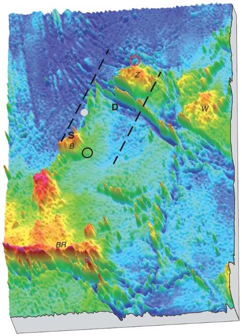
2014). For the Indian Ocean floor off the coast of western Australia, progress is being made. In late May, a map using satellite data to fill in the blanks between the sparse bathymetric
surveys of this region was released (Smith, W. H. F. & Marks, K. M. _Eos_ 95, 173–174; 2014). And as the search area expanded to a zone of around 60,000 km2, the Australian government
initiated an exercise to map the sea floor at a far higher resolution than can be obtained from satellites. Credit: © WALTER H. F. SMITH AND KAREN M. MARKS The Australian government has
indicated the data will be made publicly available to aid future scientific studies. Yet, even the relatively coarse satellite seafloor map released in May shows dramatic relief. The peaks
and plateaux charted in the map hint at pieces of continental crust left behind by the break-up of Australia and the Indian subcontinent. With a high-resolution map to come, we will
undoubtedly learn more about the evolution of the Indian Ocean floor, and its impacts on ocean processes and climate. The flight recorders of MH370 are not the only hidden remains of human
tragedy spurring exploration of the sea floor. Lying at a depth of 3,800 m beneath the Atlantic Ocean, the wreck of the RMS _Titanic_ has captivated the imagination of generations of budding
oceanographers. Exploration of the wreckage by remotely controlled vehicles and the DSV _Alvin_ submersible vehicle led to the identification of a novel bacterium (_Int. J. Syst. Evol.
Microbiol._ 60, 2768–2774; 2010) as well as a thriving ecosystem built on the ship's remains. In preparation for the making of his popular movie _Titanic_ in 1997, the director James
Cameron took part in dives to the wreckage. His growing fascination with the mysteries of the sea floor inspired his involvement with the building of the Deepsea Challenger
(http://deepseachallenge.com/). He eventually piloted the submersible to the deepest known point on Earth. During test dives to over 8,000 m in the New Britain trench, Cameron encountered
the deepest pillow lavas found to date; these features formed as lava was extruded under the high pressures of the ocean. In the Sirena Deep, he and expedition scientists found microbial
mats growing around an area thought to host serpentinization. Analyses of these mats could provide insights into both the chemical processing and the life that evolved to take advantage of
it. The Deepsea Challenger was later donated to the Woods Hole Oceanographic Institution. In the western Pacific, the rugged terrain of Nikumaroro Atoll may hide the remains of Amelia
Earhart's Electra 10E aircraft, suggests the International Group for Historical Aircraft Recovery (www.tighar.org). Earhart and her navigator disappeared along with their plane in 1937,
while trying to land on Howland Island. They were nearly three-quarters of the way into an attempt to fly around the world. The atoll is considered one of the most pristine coral reefs in
existence, based on SCUBA surveys. Seafloor mapping of the western edge of the atoll by TIGHAR shows the steep, rugged topography of the deeper coral reef. A funding appeal for an undersea
search of the atoll's western flank, scheduled to take place in the autumn of 2014, is currently underway (http://go.nature.com/nZJ8am), with a plan for two submersibles to search for
evidence of wreckage and to carry out a survey of the deep reef. It is hoped that the assessment will provide a baseline for reef diversity and health. Just as rewards such as mineral
deposits and hotspots of biodiversity lurk beneath the ocean's surface, so do hazards. Yet the ocean's floor is less well-charted than the surface of Mars or the Moon. Clearly, a
blanket of a few thousand metres of sea water is a serious obstacle to exploration. But if we can reach these depths when disaster strikes, technology is clearly not the barrier to mapping
the ocean floor. We just need to set our minds (and funds) to the task. RIGHTS AND PERMISSIONS Reprints and permissions ABOUT THIS ARTICLE CITE THIS ARTICLE Recovery and discovery. _Nature
Geosci_ 7, 477 (2014). https://doi.org/10.1038/ngeo2202 Download citation * Published: 27 June 2014 * Issue Date: July 2014 * DOI: https://doi.org/10.1038/ngeo2202 SHARE THIS ARTICLE Anyone
you share the following link with will be able to read this content: Get shareable link Sorry, a shareable link is not currently available for this article. Copy to clipboard Provided by the
Springer Nature SharedIt content-sharing initiative


