- Select a language for the TTS:
- UK English Female
- UK English Male
- US English Female
- US English Male
- Australian Female
- Australian Male
- Language selected: (auto detect) - EN
Play all audios:
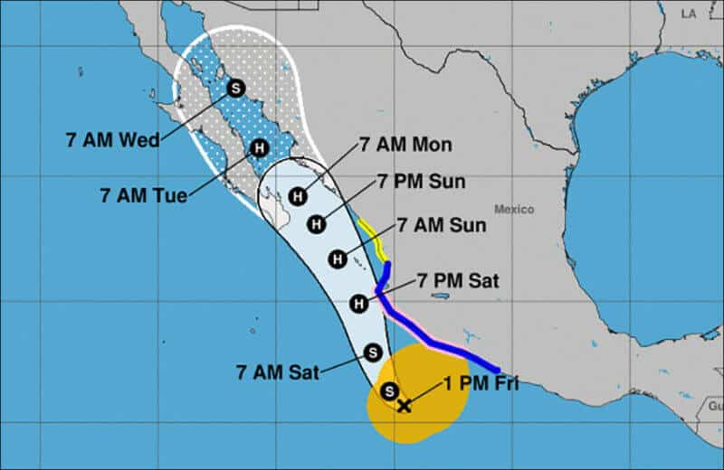
A hurricane watch is in effect for the area between Lázaro Cárdenas, Michoacán, and Cabo Corrientes, Jalisco, as Tropical Storm Nora continues to strengthen on its northwest trajectory,
according to the U.S. National Hurricane Center (NHC). As of 1:00 p.m. CDT on Friday, the storm was 385 kilometers south of Manzanillo and 980 kilometers southeast of Cabo San Lucas. It was
moving northwest at 19 kilometers per hour and is expected to approach the southwestern coast of Mexico today. It is forecast to pass close to the coast of Colima, Jalisco and Nayarit
Saturday, when it is projected to become a hurricane, and then move into the Gulf of California on Sunday and Monday. Maximum sustained winds were close to 85 kilometers per hour with higher
gusts. The National Water Commission (Conagua) warned that Nora could hit Baja California Sur as a Category 1 hurricane on Monday. In addition to the hurricane watch, a tropical storm
warning has been declared for the coastal area from Tecpán de Galeana, Guerrero, to San Blas, Nayarit, and a tropical storm watch is in effect from San Blas to Mazatlán. Heavy rains are
forecast in coastal areas of Oaxaca, Guerrero, Michoacán, Colima and Jalisco. Baja California Sur will see heavy rainfall late Sunday and Monday, the NHC said. _Mexico News Daily_