- Select a language for the TTS:
- UK English Female
- UK English Male
- US English Female
- US English Male
- Australian Female
- Australian Male
- Language selected: (auto detect) - EN
Play all audios:
ABSTRACT It is widely accepted that tectonics generally enhances river incision. However, why rivers have not incised further into orogenic plateaus to destroy terrains over long-time scales
remains ambiguous. Here we hypothesize that the diverse nature of regional tectonics could have impeded river erosion, taking Yarlung River in Tibetan Plateau as a case. We constrain the
incision history and effect of a tectonic rift on fluvial incision by low-temperature thermochronology. Results show focused cooling near the rift, but markedly reduced cooling in the
upstream and downstream regions since ~7 Ma. This coincides with an episode of rapid exhumation of Eastern Himalaya Syntaxis downstream. We propose that these two co-phased tectonic systems
resulting from accelerated extension of southern Tibetan Plateau prevented upstream migration of river knickpoints. Our study highlights that the activity of fault systems may hinder
regional erosion, thereby facilitating the preservation of topography and high plateaus in active orogenic belts. SIMILAR CONTENT BEING VIEWED BY OTHERS RECENT UPLIFT OF CHOMOLUNGMA ENHANCED
BY RIVER DRAINAGE PIRACY Article Open access 30 September 2024 MOBILITY OF SOUTH AMERICA’S TRANSCONTINENTAL DRAINAGE DIVIDE AND SHRINKAGE OF THE PARANÁ RIVER BASIN LINKED TO LITHOLOGIC AND
GEODYNAMIC CONTROLS Article Open access 24 January 2025 EXISTENCE OF A CONTINENTAL-SCALE RIVER SYSTEM IN EASTERN TIBET DURING THE LATE CRETACEOUS–EARLY PALAEOGENE Article Open access 13
December 2021 INTRODUCTION The landscape of an orogenic belt is constantly shaped by competition between tectonic uplift and bedrock river incision1. It is generally accepted that tectonic
uplift increases stream gradient, which conveys more water and sediment via orographic precipitation that facilitates faster incision2,3,4,5, driving the headward propagation of river
knickpoint6,7,8. However, why rivers have not incised further or more deeply into active orogenic plateaus to destroy uplifted low-relief terrain over geologic time remains uncertain. The
traditional explanation is that pronounced aridity in the interior plateau defeats river incision, and concomitant formation of internally drained basins9,10. Sustained internal drainage and
sedimentary infilling of basins11,12 reduce elevation contrasts, raising local base levels13. In addition, the bidirectional coupling between bedrock river incision and landslides and the
resulted drop in landslides frequency through time could lead to a corresponding decrease in the rate of fluvial incision14. Further, highly local rock uplift15,16 or derformation17, glacier
and/or landslide damming18,19,20, or dynamic feedbacks between tectonics uplift and erosion (i.e. ‘tectonic aneurysm’ model)21,22 on the plateau margins have been also viewed as
constraining features for the dissection of the plateau morphology by rivers. Thus, the controls on the erosional decay of orogenic plateaus remain controversial. This debate exists
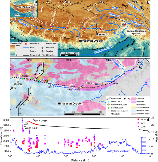
especially in the southern Tibetan Plateau, where is characterized by a relatively low-relief and high-elevation landscape (Fig. 1a, b). The Yarlung River, the largest river in the southern
Tibetan Plateau, flows eastward along the Indus-Yarlung Suture zone and then turns southward around the Eastern Himalayan Syntaxis (EHS), creating one of the deepest gorges (Fig. 1b) on
Earth16,21,22,23. Evidence from paleo-altimetry data24 and the sediments in the Himalaya foreland25 and Bengal basins26 show that similar to present-day external drainage systems and high
elevation in the southern Tibetan plateau persisted since at least 15 Ma. Meanwhile, the Tibetan plateau since the middle Miocene also underwent active east-west extension23, resulting in a
series of N-S trending rifts developed across the plateau, especially in southern Tibetan Plateau. However, it is uncertain how high elevations in the southern plateau have been sustained in
the face of river erosion and fault activity. Thermochronological ages show a younging trend from the central part of the Tibetan Plateau to the margins (i.e., northeastern and southeastern
margins), suggesting that the plateau may have progressively grown and propagated northeastwards and southeastwards27,28. This expanding uplift has been thought to accelerate river incision
from the southeastern margin to the interior plateau29,30,31,32, driving the propagation of river knickpoints into the plateau33. However, some large knickpoints along river valleys
coincide in space with local tectonic deformation. For example, knickpoints along the Yarlung River locally coincide with the late Cenozoic N-S trending tectonic rifts (Fig. 1b) that
accommodate E-W extension in southern Tibetan Plateau34. This suggests that formation of these knickpoints may have been controlled by active fault-flank uplift. Whether the diverse activity
of regional tectonics could have also inhibited knickpoint migration and thus reduced river erosion to maintain topography in southern Tibetan Plateau remains unclear. To further address
this issue, the incision history of the eastern Yarlung River valley in the southern Tibetan Plateau was constrained by low-temperature thermochronology. We collected 23 granite samples
along the Gyaca gorge (knickpoint) and the broad valley of the Yarlung River (Supplementary Note 1). A total of 22 apatite fission track (AFT), 6 apatite and 8 zircon (U-Th)/He (AHe and ZHe)
ages were obtained (Supplementary Tables 1–3), and previously published thermochronological ages33,35,36 in the eastern Yarlung River valley were also compiled (Fig. 1c, Supplementary Table
4 and Supplementary Fig. 1a). Three-dimensional (3D) thermokinematic modeling was then undertaken to explore the effect of the N-S trending rift on the formation and evolution of the
knickpoint and the incision of the Yarlung River. Combined with previous studies, we proposed that fault systems control knickpoints migration and impede river incision in the southern
Tibetan Plateau since the late Miocene. RESULTS THERMOCHRONOLOGICAL DATA New and published thermochronological ages (Supplementary Table 4) along the eastern Yarlung River (from west to east
spanning ~330 km) are presented in Fig. 1d (see Supplementary Fig. 1a for further details). Zircon (U-Th)/He (ZHe), apatite fission track (AFT), and apatite (U-Th)/He (AHe) ages range from
23.1 ± 1.4 to 7 ± 1.1 Ma, 17.5 ± 2.6 to 4.2 ± 0.4 Ma, and 9.25 ± 1.49 to 1.75 ± 0.22 Ma, respectively (Supplementary Table 4). The ZHe and AFT ages, except for the relatively young ages in
the Gyaca gorge, generally show older ages in the upstream of this gorge compared to those downstream (Fig. 1d). The AHe ages show remarkable youngest ages in the Gyaca gorge and older ages
downstream and upstream of this gorge (Fig. 1d). THERMAL HISTORY Cooling histories of the new and previous samples in the study area (divided into 6 Zones, see Fig. 2) were reconstructed
using inverse thermal history modelling by the QTQt software37 (Figs. 2a-2f). The spatial and temporal variations of the rock cooling rate since ~12 Ma were calculated from the modeling
results (Fig. 2g). The results indicate rapid cooling of the basement rocks in the eastern Yarlung valley between ~12 Ma and ~7 Ma, but the cooling rate has increased obviously in the Gyaca
gorge and decreased dramatically in its upstream and downstream since ~7 Ma (Fig. 2g). 3D THERMO-KINEMATIC MODELING To further explore possible mechanisms governing the regional erosion
history, 3D thermo-kinematic modeling strategy using Pecube was applied (detailed setting of the models described in Supplementary Table 5). We constructed two scenarios, i.e. one without
(Scenario A), and then with the influence of the Woca fault that bounds the rift structure (Scenario B) (Supplementary Fig. 2). Based on our thermal history modeling results above, the first
model (Scenario A) was set-up with a two-stage (12-7 Ma and 7-0 Ma) evolution history without Woca fault activity. More than 20,000 iterations were run to find the best fitting model that
constrains the incision rate of the Yarlung River. The best-fitting results exhibit a first stage of rapid incision rates of 1.98 km Ma−1, followed by a second stage with a decreased rate of
0.45 km Ma−1 (Supplementary Table 6 and Supplementary Fig. 3). The model predicted thermochronological ages, which are generally consistent with those actually observed for samples located
> 25 km away from the Gyaca gorge. However, for those samples located nearby the Gyaca gorge (in the footwall of the Woca fault), the predicted AFT and AHe ages are much older than those
measured (Fig. 3a, e). These large differences suggest that Scenario A, which did not integrate normal fault movements, was unable to fit the spatial distribution of observed AHe and AFT
ages (Fig. 3a, e). For Scenario B, we added a normal fault to simulate a more complex uplift velocity field. Based on our thermal history modeling results, the time of initial normal fault
activity was set at 7 Ma (Fig. 2g), and the fault trace at the surface follows that of the Woca fault (see Fig. 1c). Due to the lack of geophysical data constraining the deeper sections of
the fault, we ran three distinct inversions in which we fixed the deepest segment to be horizontal at depths of 20, 30, and 50 km, respectively. The results show that the three models for
Scenario B successfully reproduced the AHe and AFT ages in the Gyaca gorge (Fig. 3b–d, f–h), and that the spatial distribution of predicted ages is generally consistent with measured ages
(Figs. 3b–d, f–h). This confirms that incision of the eastern Yarlung River was indeed strongly influenced by a normal fault since ~7 Ma. Comparing the misfit values of the inversion for the
three models in scenario B (Fig. 3f–h, Supplementary Table 6), we found that values for the model coupled with a 30 (3.92) or 50 km-depth fault (4.07) seem a little lower than that for a 20
km-depth fault (4.17). This would indicate that the depth of the Woca fault could reach up to ~30 km or more. Furthermore, these models predict a steep (68°∼75°) fault in the shallow crust,
near the surface (Fig. 3c, d), and a fault-slip velocity rate of 1.19 ± 0.03 km Ma−1 since 7 Ma (Supplementary Table 6 and Supplementary Figs. 4–6). This finding is in very good agreement
with the observed high-angle fault geometry of 60° ~ 75°38 and the Quarternary slip rate of 1.2 ± 0.6 km Ma−139. The model also shows that the incision rate along the eastern Yarlung River
was up to 1.73 ± 0.07 km Ma−1 between 12 Ma and 7 Ma, followed by a rather slow incision rate of 0.18 ± 0.03 km Ma−1 upstream and downstream of the Gyaca gorge since 7 Ma (Supplementary
Table 6 and Supplementary Figs. 4–6). This is also broadly consistent with the thermochronology results. DISCUSSION FAULT ACTIVITY CONTROLS THE FORMATION OF KNICKPOINT In a previous study33,
Schmidt et al. proposed that the Gyaca knickpoint resulted from upstream migration of erosional waves starting from the Yarlung Tsangpo Grand Canyon (Fig. 1b) in response to uplift of the
southeastern Tibetan Plateau prior to ∼10 Ma33. However, no geomorphic evidence (e.g., terraces) for downstream knickpoint retreat has been reported, although the decrease of base level at
the Yarlung Tsangpo Grand Canyon might result in fluvial incision33. Our modeling results suggest that both headward incision of the Yarlung River since ~12 Ma due to uplift of the
southeastern Tibetan Plateau33 or intensified monsoon precipitation40,41 are not compatible with the remarkable young AHe and AFT ages in the Gyaca gorge (Fig. 3e). In addition, rock
outcrops in the Gyaca gorge and its downstream valley are mainly granitoids (Fig. 1c), thus lithological variation cannot be attributed as a major controlling factor for the formation of the
Gyaca gorge. In contrast, as indicated by the well constrained Pecube model, a high-angle normal fault is required (Scenario B), to fit with an increased rock cooling rate at the Gyaca
gorge since ~7 Ma (Fig. 3g). Therefore, we argue that movement of the Woca fault has controlled the formation of the Gyaca knickpoint since ~7 Ma, and that a similar mechanism might also
explain the formation of other large knickpoints in the middle and upper reaches of the Yarlung River (Fig. 1b). Based on QTQt and Pecube modeling results, a relatively high incision rate (
~ 1.73 ± 0.07 km Ma−1) of the eastern Yarlung River initiated at ∼12 Ma, with a slightly decreasing trend in thermochronological ages from west to east along the Yarlung River. Published
thermochronometric data from the externally drained portion of the eastern15,42,43 and central44,45 Lhasa terrane, as well as from large rivers in the southeastern Tibetan Plateau41,46,
demonstrate that rapid exhumation rates ( > 1 km Ma−1) were pervasive across the southern and southeastern plateau between ∼17 and 10 Ma. These spatially large-scale synchronous rapid
incision events most likely reflect enhanced Asian summer monsoon precipitation in the mid-Miocene40,41 that promoted the headward erosion of the Yarlung River channels (Fig. 4a). However,
the incision rate upstream and downstream of the Gyaca gorge has decreased dramatically with the rapid activity of the Woca fault since 7 Ma (Fig. 2g and Supplementary Table 6). ONSET OF EHS
EXHUMATION AND ITS LINK TO RIFTING Thermochronometric data from rifts in the Tibetan Plateau47,48 suggest that southern Tibetan Plateau has experienced rapid late Miocene to Pliocene rift
acceleration34 (see Supplementary Fig. 7). This rapid rift activity with accelerated extension of southern Tibetan Plateau controls knickpoints, such as the Gyaca knickpoint, in the plateau
interior. Further, the high rate of rifts extension in southern Tibetan Plateau also facilitate thinning of the upper crust while its lower crust is thickened by ongoing compression34,49,50.
This could contribute to accelerating eastward crustal flow51 at the Eastern Himalayan Syntaxis (EHS) driving localized deformation and uplift52,53,54, leading to active coupling between
crustal rock advection and river erosion55 since ~7 Ma (Fig. 4b). Detrital thermochronological data from foreland basin sediments downstream of the EHS also suggest coupling between tectonic
uplift and erosion starting at 8 Ma55, 7-5 Ma56 and/or 6-4 Ma57. Currently, the mechanism of rapid exhumation in the EHS remains controversial. A current paradigm is the Tectonic Aneurysm
model, in which spatially focused surface erosion driven by the Yarlung River locally might accelerate rock uplift and exhumation of hot and weak crust at the syntaxes21,22,58. Evidence from
sediments in the Himalaya foreland25, Bengal basins26 and our thermochronometric data (Fig. 2) show that the Yarlung River was definitely set in its course before ~12 Ma. However, this does
not specifically address the role of the Yarlung River in driving initial rapid exhumation of the EHS, which is thought to have begun 8-6 Ma55,56,57. Although Wang et al. argued for a rapid
uplift of the EHS at ∼2.5 Ma based on sediment fill immediately upstream of the Yarlung Zangbo gorge16,59,60, we consider this as only one of several stages of EHS uplift, rather than the
initial uplift episode. The work by King et al. shows that the optically stimulated luminescence thermochronology to the northeast of the Namche Barwa supports the idea of northward
migration of the high exhumation locus (as proposed by Seward and Burg61) instead of control by localized very fast fluvial incision62. Here, we find evidence for a synchronous exhumation
pulse in the rifts (Supplementary Fig. 7) and EHS55 since the late Miocene. This rapid exhumation implies that the tectonic system resulting from the accelerated late Miocene extension of
southern Tibetan Plateau drove regional fault activity to control rapid exhumation and the formation of stable knickpoints in the rifts and EHS. CONTRIBUTION OF STABLE KNICKPOINTS TO THE
STABILIZATION OF SOUTHERN TIBETAN PLATEAU With the stabilization of knickpoints, the landscape equilibrates towards topographic steady-state equilibrium whereby for a given climatic
condition, the slope of rivers adjust toward a geometry that allows an incision rate equal to rock uplift rate63. Therefore, the surface uplift rate might be zero, which would sustain a
high-elevation base level for the Yarlung River in the rifts and EHS. Meanwhile, coeval tectonic evolution with the accelerated late Miocene extension of southern Tibetan Plateau contribute
to the stabilization of southern Tibetan Plateau. If only local fault activity of the rift controlled the Gyaca knickpoint (Fig. 1b, c), and the localized deformation and uplift of EHS
downstream were not particularly fast, so that EHS knickpoint was not fixed (Fig. 1b), it would migrate headwards, gradually towards the Gyaca gorge. This would cause the base level to fall
in the region and the river would incise more deeply into the plateau interior. With the stabilization of the knickpoints, river gradients above the knickpoints are commonly so low that
fluvial incision may generally have difficulty in keeping up with increase in tectonic uplift rates. As a result, channel slope and stream power would decrease transiently above these
Yarlung River knickpoints (Fig. 4b). Simultaneously, the reduced river gradient and sediment flux could promote upstream aggradation, burial of bedrock valley floors19,64,65, and valley
widening (Fig. 1d, b), which could cause widespread backwater aggradation, forming broad valley trains occupied today by braided river systems (Fig. 1d and Supplementary Fig. 1b–f). Field
survey also found large paleo-lakes66 upstream and valley-fill sediments16 downstream of Gyaca gorge (Supplementary Fig. 8). This braided river only incised when the stripping of deposited
alluvial material exposed bedrock to processes of abrasion, weathering and plucking67. Therefore, the erosion rate of the river above the knickpoints will be reduced obviously due to the
reduction of stream power since the late Miocene. This is supported by the predicted low erosion rates (0.18 ± 0.03 km Ma−1) (Supplementary Table 6 and Supplementary Figs. 4–6), which is in
agreement with the rates (0.04–0.20 km Ma−1) determined from cosmogenic nuclide (10Be) data in the middle reaches of the Yarlung River68. Hence, coeval tectonic systems (rifting upstream and
uplift and exhumation of the EHS downstream) with the accelerated extension of southern Tibetan Plateau resulted not only in upstream reduction in river gradient and stream power, but also
stabilized downstream base levels, i.e. from a stable knickpoint at the EHS. This would subsequently drive the onset of stable knickpoints formation in the Gyaca and EHS, thereby impeding a
wave of upstream erosion and facilitating the stabilization of southern Tibetan Plateau topography since the late Miocene. PROCESSES CONTROLLING THE STABILITY/INSTABILITY OF KNICKPOINTS IN
ACTIVE OROGENS When uplift rates are spatially variable for a given climatic condition, two fundamentally distinctive types of knickpoints (i.e. transient and stationary knickpoints) might
develop under different conditions3,4,69. Transient knickpoints, which may be produced by a change in the background regional uplift rate or a discrete base-level lowering event69. Whereas
stationary knickpoints may reflect abrupt spatial changes in uplift/incision rate69, and/or a hard basement3. Based on our results (Fig. 4) and published literature69, we suggest that the
transient migration and stability of river knickpoints might coexist during the evolution of orogenic belts. For example, many other active orogenic belts also first grow to a certain
height, and then experience laterally outward propagation70. This expanding uplift generally increases the steepness of rivers, and promotes upstream erosion30,31,32. But this expansion is
not a simple one-dimensional process, it might also be accompanied by diverse strong regional tectonic deformation of the upper crust17,71,72 (e.g., rifting, subduction, and strike-slip
faulting) and lower crustal flow51. Lower crustal flow in turn will promote and further drive regional tectonic deformation of the upper crust, leading to the stability of knickpoints. An
excellent example of channel adjustment to tectonic forcing is the Eastern-Western Himalaya Syntaxis52,53. However, clearly not all knickpoints associated with active faulting are stalled,
such as the locations of the Hatay Graben in Turkey73, a normal fault system in the eastern California3 and the headwaters of the Yellow River in the Tibetan Plateau74, which might be mainly
related to the dip and slip rate of faults73,74. The Woca normal fault in this study is dipping in the upstream direction (Fig. 1c), which might reduce the amount of base-level fall
experienced by that part of the Tibetan Plateau which is drained by the Yarlung River. Thus, we propose that the activity of the local fault systems can limit the migration of these river
knickpoints under specific conditions, such as those on the eastern Yarlung River, which are still located in the area of regional tectonic deformation (Fig. 5). This process should
subsequently reduce fluvial incision in the upstream and prevent base-level fall downstream of the knickpoints. This might stabilize the topography of the Plateau and protect high-elevation,
low-relief surfaces over geologic time in active orogenic belts. Our findings suggest that tectonic activity does not always necessarily enhance fluvial incision, and that the diverse
activity can also decrease these rates by the adjustment of fault systems in active orogenic belts. This finding also provides a new mechanism for explaining the universal stability of
topography and high plateaus in some other orogenic belts. METHODS THERMOCHRONOLOGICAL DATA AND THERMAL HISTORY Apatite and zircon separates were concentrated using standard heavy liquid and
magnetic separation techniques. Analyses were performed at the School of Geography, Earth and Atmospheric Sciences, University of Melbourne (see Supplementary Note 2, 3 for further
details). The thermal histories based on these thermochronological data were determined using the QTQt software37 (details in Supplementary Note 4), and spatial and temporal cooling pattern
and rates along the Yarlung River were calculated based on the model results. 3D THERMO-KINEMATIC MODELING To identify detailed effects of rift activity on Yarlung River incision, we used
the thermokinematic finite-element Pecube75 code, which has been developed to interpret thermochronological data by solving a 3D crustal heat-transport equation. We constructed two scenarios
in Pecube, i.e. without (Scenario A) and with the influences of the Woca fault (Scenario B) (detailed model parameters are described in Supplementary Note 5). In Scenario A, the Yarlung
River was incised from a flat plateau surface to form the topography, ignoring the influence of the Woca normal fault in the plateau interior. This scenario mainly reflects the upstream
migration of erosional waves of the Yarlung River (Supplementary Fig. 2). In Scenario B, we considered not only the incision of the Yarlung River, but also incorporated the effect of the
Woca normal fault (see Supplementary Fig. 2). DATA AVAILABILITY All thermochronological data used in this study are available in https://figshare.com/s/4aa78f1a9ebd4c7105a2. Results of
thermal history models from QTQt and 3D thermo-kinematic inversion in this study have been deposited in the Figshare Data Repository, respectively.
(https://figshare.com/articles/figure/QTQt/22110746); (https://figshare.com/s/dd1203e7834449827c74). Topographic and faults data in Figs. 1 and 5 are obtained from the open-source databases
(https://www.ngdc.noaa.gov/mgg/topo/ and https://github.com/HimaTibetMap/HimaTibetMap). CODE AVAILABILITY The code Pecube, used in this work, is open source and can be downloaded at
https://github.com/jeanbraun/Pecube. REFERENCES * England, P. & Molnar, P. Surface uplift, uplift of rocks, and exhumation of rocks. _Geology_ 19, 1051–1053 (1991). Google Scholar *
Clark, M. et al. Surface uplift, tectonics, and erosion of Eastern Tibet from large-scale drainage patterns. _Tectonics_ 23, TC1006 (2004). Article Google Scholar * Kirby, E. &
Whipple, K. Expression of active tectonics in erosional landscapes. _J. Struct. Geol._ 44, 54–75 (2012). Article Google Scholar * Whipple, K. Bedrock rivers and the geomorphology of active
orogens. _Annu. Rev. Earth Planet. Sci._ 32, 151 (2004). Article CAS Google Scholar * Lease, R. & Ehlers, T. Incision into the eastern Andean Plateau during Pliocene cooling.
_Science (New York, NY)_ 341, 774–776 (2013). Article CAS Google Scholar * Schildgen, T. F., Balco, G. & Shuster, D. L. Canyon incision and knickpoint propagation recorded by apatite
He4/He3 thermochronometry. _Earth Planet. Sci. Lett._ 293, 377–387 (2010). Article CAS Google Scholar * Yang, R. et al. Spatial and temporal pattern of erosion in the three rivers region,
southeastern Tibet. _Earth Planet. Sci. Lett._ 433, 10–20 (2016). Article CAS Google Scholar * Willett, S., McCoy, S., Perron, J., Goren, L. & Chen, C. Y. Dynamic reorganization of
river Basins. _Science (New York, NY)_ 343, 1117 (2014). Article CAS Google Scholar * Sobel, E., Hilley, G. & Strecker, M. Formation of internally drained contractional basins by
aridity-limited bedrock incision. _J. Geophys. Res.: Atmos._ 108, 1–6 (2003). Article Google Scholar * Garcia-Castellanos, D. The role of climate during high plateau formation. Insights
from numerical experiments. _Earth Planet. Sci. Lett._ 257, 3–4 (2007). Google Scholar * Heidarzadeh, G., Ballato, P., Hassanzadeh, J., Ghassemi, M. & Strecker, M. Lake overspill and
onset of fluvial incision in the Iranian Plateau: Insights from the Mianeh Basin. _Earth Planet. Sci. Lett._ 469, 135–147 (2017). Article CAS Google Scholar * House, P., Pearthree, P.
& Perkins, M. Stratigraphic evidence for the role of lake spillover in the inception of the lower Colorado River in southern Nevada and western Arizona. _Spec. Pap. Geol. Soc. Am._ 439,
335–353 (2008). Google Scholar * Pingel, H., Alonso, R., Altenberger, U., Cottle, J. & Strecker, M. Miocene to Quaternary basin evolution at the southeastern Andean Plateau (Puna)
margin (~24°S lat, Northwestern Argentina). _Basin Res._ 31, 808–826 (2019). Article Google Scholar * Egholm, D. L., Knudsen, M. F. & Sandiford, M. Lifespan of mountain ranges scaled
by feedbacks between landsliding and erosion by rivers. _Nature_ 498, 475–478 (2013). Article CAS Google Scholar * Tremblay, M. M. et al. Erosion in southern Tibet shut down at ~ 10 Ma
due to enhanced rock uplift within the Himalaya. _Proc. Natl. Acad. Sci. USA_ 112, 12030–12035 (2015). Article CAS Google Scholar * Wang, P. et al. Tectonic control of Yarlung Tsangpo
Gorge revealed by a buried canyon in Southern Tibet. _Science_ 346, 978–981 (2014). Article CAS Google Scholar * Seagren, E. & Schoenbohm, L. Drainage Reorganization Across the Puna
Plateau Margin (NW Argentina): Implications for the Preservation of Orogenic Plateaus. _J. Geophys. Res._ 126, 1–28 (2021). Google Scholar * Korup, O. & Montgomery, D. Tibetan plateau
river incision inhibited by glacial stabilization of the Tsangpo gorge. _Nature_ 455, 786–789 (2008). Article CAS Google Scholar * Korup, O., Montgomery, D. & Hewitt, K. Glacier and
landslide feedbacks to topographic relief in the Himalayan syntaxes. _Proc. Natl. Acad. Sci. USA_ 107, 5317–5322 (2010). Article CAS Google Scholar * Owen, L. Geomorphology: How Tibet
might keep its edge. _Nature_ 455, 748–749 (2008). Article CAS Google Scholar * Zeitler, P. et al. Erosion, Himalayan geodynamics, and the geomorphology of metamorphism. _GSA Today_ 11,
4–9 (2001). Article Google Scholar * Koons, P. O., Zeitler, P., & Hallet, B. Tectonic Aneurysms and Mountain Building, in Treatise on Geomorphology, John F. Shroder, Ed. (Academic
Press, San Diego), pp. 318–349. 2013. * Yin, A. & Harrison, T. M. Geologic evolution of the Himalayan-Tibetan orogen. _Annu. Rev. Earth Planet. Sci._ 28, 211–280 (2000). Article CAS
Google Scholar * Spicer, R. et al. Constant elevation of southern Tibet over the past 15 million years. _Nature_ 421, 622–624 (2003). Article CAS Google Scholar * Lang, K. &
Huntington, K. Antecedence of the Yarlung–Siang–Brahmaputra River, eastern Himalaya. _Earth Planet. Sci. Lett._ 397, 145–158 (2014). Article CAS Google Scholar * Bracciali, L., Najman,
Y., Parrish, R., Akhter, S. & Millar, I. The Brahmaputra tale of tectonics and erosion: Early Miocene river capture in the Eastern Himalaya. _Earth Planet. Sci. Lett._ 415, 25–37 (2015).
Article CAS Google Scholar * Li, Y. L. et al. Propagation of the deformation and growth of the Tibetan-Himalayan orogen: A review. _Earth Sci. Rev._ 143, 36–61 (2015). Article Google
Scholar * Li, H. A. et al. The formation and expansion of the eastern Proto-Tibetan Plateau: Insights from low-temperature thermochronology. _J. Asian Earth Sci._ 183, 103975 (2019).
Article Google Scholar * Clark, M. et al. Late Cenozoic uplift Southeastern Tibet. _Geology_ 33, 525–528 (2005). Article Google Scholar * Harkins, N., Kirby, E., Heimsath, A., Robinson,
R. & Reiser, U. Transient Fluvial Incision in the Headwaters of the Yellow River, Northeastern Tibet, China. _J. Geophys. Res._ 112, 3–4 (2007). Article Google Scholar * Ouimet, W. et
al. Regional incision of the eastern margin of the Tibetan Plateau. _Lithosphere_ 2, 50–63 (2010). Article Google Scholar * Yuan, X. et al. Propagating uplift controls on high-elevation,
low-relief landscape formation in the southeast Tibetan Plateau. _Geology_ 50, 60–65 (2021). Article Google Scholar * Schmidt, J. et al. Knickpoint evolution on the Yarlung river: Evidence
for late Cenozoic uplift of the southeastern Tibetan plateau margin. _Earth Planet. Sci. Lett._ 430, 448–457 (2015). Article CAS Google Scholar * Styron, R., Taylor, M. & Sundell, K.
Accelerated extension of Tibet linked to the northward underthrusting of Indian crust. _Nat. Geosci._ 8, 131–134 (2015). Article CAS Google Scholar * Dai, J. G. et al. Two stages of
accelerated exhumation in the middle reach of the Yarlung River, Southern Tibet since the mid‐Miocene. _Tectonics_ 40, 1–17 (2021). Article Google Scholar * Li, G. et al. Cenozoic low
temperature cooling history of the Northern Tethyan Himalaya in Zedang, SE Tibet and its implications. _Tectonophysics_ 643, 80–93 (2015). Article Google Scholar * Gallagher, K.
Transdimensional inverse thermal history modeling for quantitative thermochronology. _J. Geophys. Res.: Solid Earth_ 117, 1–16 (2012). Article Google Scholar * Wu, Z., Zhang, Y., Hu, D.
& Zhao, X. Late Cenozoic normal faulting of the Qungdogyang graben in the central segment of the Cona-Oiga rift, Southeastern Tibet. _Journal of Geomechanics_ 13, 297–306 (2007). Google
Scholar * Wu, Z., Zhang, Y., Hu, D. G., Zhao, X. & Ye, P. S. The Quaternary normal faulting of the Cona-Oiga rift. _Seismology and Geology_ 30, 144–160 (2008). Google Scholar * Clift,
P. D. et al. Correlation of Himalayan exhumation rates and Asian monsoon intensity. _Nat. Geosci._ 1, 875–880 (2008). Article CAS Google Scholar * Nie, J. S. et al. Rapid incision of the
Mekong River in the middle Miocene linked to monsoonal precipitation. _Nat. Geosci._ 11, 944–948 (2018). Article CAS Google Scholar * Copeland, P. et al. Thermal evolution of the Gangdese
batholith, southern Tibet: A history of episodic unroofing. _Tectonics_ 14, 223–236 (1995). Article Google Scholar * Li, G. W. et al. Synorogenic morphotectonic evolution of the Gangdese
batholith, South Tibet: Insights from low-temperature thermochronology. _Geochem., Geophys., Geosyst._ 17, 101–112 (2016). Article Google Scholar * Carrapa, B. et al. Miocene burial and
exhumation of the India-Asia collision zone in southern Tibet: Response to slab dynamics and erosion. _Geology_ 42, 443–446 (2014). Article Google Scholar * Su, W. et al. Late Oligocene -
Miocene morpho-tectonic evolution of the central Gangdese batholith constrained by low-temperature thermochronology. _Tectonophysics_ 840, 229559 (2022). Article Google Scholar * Cai, D.,
Wang, X., Li, G., Zhu, W. & Lu, H. Late Cenozoic denudation and topographic evolution history of the Lhasa River drainage in southern Tibetan Plateau: insights from inverse thermal
history modeling. _Front. Earth Sci._ 9, 636459 (2022). Article Google Scholar * Bian, S. et al. Late Pliocene onset of the Cona rift, eastern Himalaya, confirms eastward propagation of
extension in Himalayan-Tibetan orogen. _Earth Planet. Sci. Lett._ 544, 116383 (2020). Article CAS Google Scholar * Lee, J. et al. Middle to late Miocene extremely rapid exhumation and
thermal reequilibration in the Kung Co rift, southern Tibet. _Tectonics_ 30, 1–26 (2011). Article Google Scholar * McDermott, J., Whipple, K., Hodges, K. & van Soest, M. Evidence for
Plio-Pleistocene north-south extension at the southern margin of the Tibetan Plateau, Nyalam region. _Tectonics_ 32, 317–333 (2013). Article Google Scholar * Sundell, K. et al. Evidence
for constriction and Pliocene acceleration of east-west extension in the North Lunggar rift region of west central Tibet. _Tectonics_ 32, 1454–1479 (2013). Article Google Scholar * Clark,
M. & Royden, L. Topographic ooze: Building the eastern margin of Tibet by lower crustal flow. _Geology_ 28, 703–706 (2000). Article Google Scholar * Whipp, D., Beaumont, C. &
Braun, J. Feeding the “aneurysm”: Orogen-parallel mass transport into Nanga Parbat and the western Himalayan syntaxis. _J. Geophys. Res: Solid Earth_ 119, 5077–5096 (2014). Article Google
Scholar * Ding, L., Zhong, D., Yin, A., Kapp, P. & Harrison, T. M. Cenozoic structural and metamorphic evolution of the eastern Himalayan syntaxis (Namche Barwa). _Earth Planet. Sci.
Lett._ 192, 423–438 (2001). Article CAS Google Scholar * Guevara, V. et al. A modern pulse of ultrafast exhumation and diachronous crustal melting in the Nanga Parbat Massif. _Science
Advances_ 8, eabm2689 (2022). Article CAS Google Scholar * Govin, G. et al. Early onset and late acceleration of rapid exhumation in the Namche Barwa syntaxis, eastern Himalaya. _Geology_
48, 1139–1143 (2020). Article CAS Google Scholar * Lang, K., Huntington, K., Burmester, R. & Housen, B. Rapid exhumation of the eastern Himalayan syntaxis since the late Miocene.
_Geol. Soc. Am. Bull._ 128, 1403–1422 (2016). Article CAS Google Scholar * Najman, Y. et al. Spatial and temporal trends in exhumation of the Eastern Himalaya and syntaxis as determined
from a multitechnique detrital thermochronological study of the Bengal Fan. _Geol. Soc. Am. Bull._ 131, 1607–1622 (2019). Article Google Scholar * Hodges, K. & Whipple, K. Dynamic
processes at the ends of collisional mountain chains. _Science advances_ 8, eade6607 (2022). Article CAS Google Scholar * Zeitler, P., Koons, P., Hallet, B. & Meltzer, A.
Geomorphology. Comment on “Tectonic control of Yarlung Tsangpo Gorge revealed by a buried canyon in Southern Tibet”. _Science (New York, NY)_ 349, 799 (2015). Article CAS Google Scholar *
Wang, P. et al. Response to Comment on “Tectonic control of Yarlung Tsangpo Gorge revealed by a buried canyon in Southern Tibet”. _Science_ 349, 799 (2015). Article CAS Google Scholar *
Seward, D. & Burg, J. P. Growth of the Namche Barwa Syntaxis and associated evolution of the Tsangpo Gorge: Constraints from structural and thermochronological data. _Tectonophysics_
451, 282–289 (2008). Article Google Scholar * King, G., Herman, F. & Guralnik, B. Northward migration of the eastern Himalayan syntaxis revealed by OSL thermochronometry. _Science_
353, 800–804 (2016). Article CAS Google Scholar * Tejedor, A., Singh, A., Zaliapin, I., Densmore, A. & Foufoula-Georgiou, E. Scale-dependent erosional patterns in steady-state and
transient-state landscapes. _Science Advances_ 3, e1701683 (2017). Article Google Scholar * Humphrey, N. & Konrad, S. River incision or diversion in response to bedrock uplift.
_Geology_ 28, 43–46 (2000). Article Google Scholar * Hilley, G. & Strecker, M. Processes of oscillatory basin filling and excavation in a tectonically active orogen: Quebrada Del Toro
Basin, NW Argentina. _Geol. Soc. Am. Bull._ 117, 887–901 (2005). Article Google Scholar * Zhu, S., Wu, Z. H., Zhao, X. T. & Xiao, K. Y. Glacial dammed lakes in the Tsangpo River during
late Pleistocene, southeastern Tibet. _Quat. Int._ 298, 114–122 (2013). Article Google Scholar * Finnegan, N., Schumer, R. & Finnegan, S. A signature of transience in bedrock river
incision rates over timescales of 104-107 years. _Nature_ 505, 391–394 (2014). Article CAS Google Scholar * Lupker, M. et al. 10Be systematics in the Tsangpo-Brahmaputra catchment: the
cosmogenic nuclide legacy of the eastern Himalayan syntaxis. _Earth Surf. Dynam._ 5, 429–449 (2017). Article Google Scholar * Royden, L. & Perron, J. Solutions of the stream power
equation and application to the evolution of river longitudinal profiles. _J. Geophys. Res: Earth Surf._ 118, 497–518 (2013). * Wolf, S., Huismans, R., Muñoz, J., Curry, M. & van der
Beek, P. Growth of collisional orogens from small and cold to large and hot-inferences from geodynamic models. _J. Geophys. Res.: Solid Earth_ 126, e2020JB021168 (2021). * Molnar, P. et al.
Continuous deformation versus faulting through the continental lithosphere of New Zealand. _Science (New York, NY)_ 286, 516–519 (1999). Article CAS Google Scholar * Molnar, P. &
Tapponnier, P. Cenozoic tectonics of Asia: Effects of a continental collision. _Science_ 189, 419–426 (1975). Article CAS Google Scholar * Whittaker, A. & Boulton, S. Tectonic and
climatic controls on knickpoint retreat rates and landscape response times. _J. Geophys. Res.: Solid Earth_ 117, 2024 (2012). Article Google Scholar * Liu, Y. et al. Late Quaternary
terrace formation from knickpoint propagation in the headwaters of the Yellow River, NE Tibetan Plateau. _Earth Surf. Process. Landf._ 46, 2788–2806 (2022). Article Google Scholar * Braun,
J. et al. Quantifying rates of landscape evolution and tectonic processes by thermochronology and numerical modeling of crustal heat transport using PECUBE. _Tectonophysics_ 524, 1–28
(2012). Article Google Scholar * Pan, G., Ding, J., Yao, D. & Wang, L. Geological map of the Qinghai-Xizang (Tibet) Plateau and adjacent areas, with guidebook. (2004). Download
references ACKNOWLEDGEMENTS This research is supported by National Natural Science Foundation of China (42021001, 41971005, 42272111) and Second Tibetan Plateau Scientific Expedition Program
(2019QZKK0205, 2019QZKK0204). The University of Melbourne thermochronology laboratory receives support under the AuScope program (auscope.org.au) of the Australian Government’s National
Collaborative Research Infrastructure Strategy (NCRIS). For this study, sampling permissions were obtained. We thank the reviewers for their constructive suggestions for improving the
manuscript and the editor, Joao Duarte, for professional editorial handling. AUTHOR INFORMATION AUTHORS AND AFFILIATIONS * Frontiers Science Center for Critical Earth Material Cycling,
School of Geography and Ocean Science, Nanjing University, Nanjing, 210023, China Dongxu Cai, Xianyan Wang & Huayu Lu * Key Laboratory of Tibetan Plateau Land Surface Processes and
Ecological Conservation (Ministry of Education), Xining, 810016, China Xianyan Wang * State Key Laboratory for Mineral Deposits Research, School of Earth Sciences and Engineering, Nanjing
University, Nanjing, 210023, China Guangwei Li & Wenbin Zhu * School of Earth and Ocean Sciences, University of Victoria, Victoria, Canada Ruohong Jiao * School of Geography, Earth and
Atmospheric Sciences, University of Melbourne, Melbourne, 3010, Australia Barry Kohn * Laboratory for Mineralogy and Petrology, Department of Geology, Ghent University, Krijgslaan 281,
Ghent, 9000, Belgium Johan De Grave Authors * Dongxu Cai View author publications You can also search for this author inPubMed Google Scholar * Xianyan Wang View author publications You can
also search for this author inPubMed Google Scholar * Guangwei Li View author publications You can also search for this author inPubMed Google Scholar * Ruohong Jiao View author publications
You can also search for this author inPubMed Google Scholar * Barry Kohn View author publications You can also search for this author inPubMed Google Scholar * Wenbin Zhu View author
publications You can also search for this author inPubMed Google Scholar * Johan De Grave View author publications You can also search for this author inPubMed Google Scholar * Huayu Lu View
author publications You can also search for this author inPubMed Google Scholar CONTRIBUTIONS X.W. and G.L. developed the conceptual idea, designed and organized the study, and wrote the
manuscript with D.C.; G.L. conducted fieldwork and processed data. X.W., G.L., and D.C. analyzed the data, tested the numerical simulations, and created all figures. X.W., G.L., D.C., R.J.,
B.K., W.Z., J.D.G, and H.L. discussed and revised early versions of the ideas. All authors contributed to the discussion and writing of the manuscript. CORRESPONDING AUTHORS Correspondence
to Xianyan Wang or Guangwei Li. ETHICS DECLARATIONS COMPETING INTERESTS The authors declare no competing interests. PEER REVIEW PEER REVIEW INFORMATION _Communications Earth &
Environment_ thanks Erin Seagren, Luca Malatesta and the other, anonymous, reviewer(s) for their contribution to the peer review of this work. Primary Handling Editors: João Duarte and Joe
Aslin. A peer review file is available ADDITIONAL INFORMATION PUBLISHER’S NOTE Springer Nature remains neutral with regard to jurisdictional claims in published maps and institutional
affiliations. SUPPLEMENTARY INFORMATION SUPPLEMENTARY INFORMATION PEER REVIEW FILE RIGHTS AND PERMISSIONS OPEN ACCESS This article is licensed under a Creative Commons Attribution 4.0
International License, which permits use, sharing, adaptation, distribution and reproduction in any medium or format, as long as you give appropriate credit to the original author(s) and the
source, provide a link to the Creative Commons licence, and indicate if changes were made. The images or other third party material in this article are included in the article’s Creative
Commons licence, unless indicated otherwise in a credit line to the material. If material is not included in the article’s Creative Commons licence and your intended use is not permitted by
statutory regulation or exceeds the permitted use, you will need to obtain permission directly from the copyright holder. To view a copy of this licence, visit
http://creativecommons.org/licenses/by/4.0/. Reprints and permissions ABOUT THIS ARTICLE CITE THIS ARTICLE Cai, D., Wang, X., Li, G. _et al._ Fault systems impede incision of the Yarlung
river into the Tibetan plateau. _Commun Earth Environ_ 4, 200 (2023). https://doi.org/10.1038/s43247-023-00861-y Download citation * Received: 03 November 2022 * Accepted: 22 May 2023 *
Published: 05 June 2023 * DOI: https://doi.org/10.1038/s43247-023-00861-y SHARE THIS ARTICLE Anyone you share the following link with will be able to read this content: Get shareable link
Sorry, a shareable link is not currently available for this article. Copy to clipboard Provided by the Springer Nature SharedIt content-sharing initiative