- Select a language for the TTS:
- UK English Female
- UK English Male
- US English Female
- US English Male
- Australian Female
- Australian Male
- Language selected: (auto detect) - EN
Play all audios:
Download PDF Article Open access Published: 01 March 2025 Thresholds in East Asian marginal seas circulation due to deglacial sea level rise Xun Gong1,2,3,4,5, Yang Yu6, Xuefa Shi2,7,
Xiaopei Lin ORCID: orcid.org/0000-0001-6413-44798,9, Guangliang Liu1,5, Zhi Dong2,7, Xuesong Wang3, Jiong Zheng3, Lester Lembke-Jene ORCID: orcid.org/0000-0002-6873-85334 & …Gerrit Lohmann
ORCID: orcid.org/0000-0003-2089-733X4,10 Show authors npj Climate and Atmospheric Science volume 8, Article number: 83 (2025) Cite this article
1311 Accesses
9 Altmetric
Metrics details
Subjects PalaeoceanographyPhysical oceanography AbstractEast Asian marginal seas (EAMS) circulation is closely configurated by sea level rise during the last deglaciation. Here, we perform simulations to reconstruct the EAMS circulation on the
basis of sea levels from −90 to 0 m of the present, using a high-resolution regional ocean circulation model under present-day fixed surface and lateral boundary conditions. Our results show
that the EAMS circulation underwent twice abrupt changes: a rapid initiation of its modern structure when sea level rise exceeded −40 m, followed by a temporary overshoot of the Japan-Sea
throughflows at −5 m. These nonlinear processes are caused by the opening of the Soya Strait and thus formation of the modern EAMS-circulation structure, and a transient absence of the
circulation resembling a Kuroshio Large Meander following around-island integral constraint, respectively. Conceptually, our findings introduce the around-island integral constraint on
abrupt shift in the global marginal-sea circulation during the last deglaciation.
Similar content being viewed by others A process-based assessment of the sea-level rise in thenorthwestern Pacific marginal seas Article Open access 26 August 2023 Delayed Antarctic sea-ice decline in high-resolution climate change simulations Article Open access 02 February 2022
Sea-ice retreat suggests re-organization of water mass transformation in the Nordic and Barents Seas Article Open access 10 January 2022 Introduction
Extraordinary rise of sea level is a most challenging climatic effect, as a consequence of the on-going global warming1,2,3. According to paleoceanographic evidences, sea level was even
higher than the modern condition by a few meters during the last interglacial (~ 130–115 ka BP), as a heritage of naturally deglacial sea level rise4,5. On the glacial-interglacial time
scales, the global ocean has tempered the effect of sea level oscillations by over 100 m4, in particular for the marginal seas via the processes of land-sea evolution. This is a typical
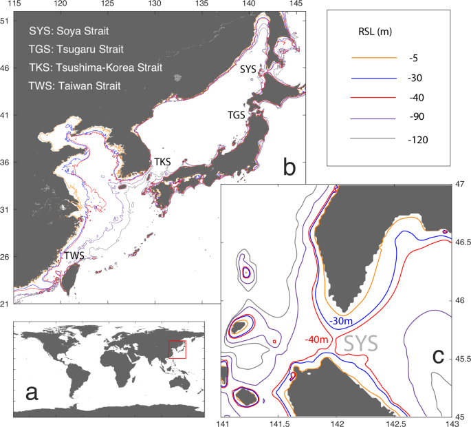
circumstance for the development of circulation in the East Asian marginal seas (EAMS, one of globally largest marginal-sea region) since the last deglaciation (Fig. 1 and Supplementary fig.
1). Although studies have linked the deglacial evolution in the EAMS circulation to the coeval climatic processes of e.g., Asian Monsoons6,7,8 and the Kuroshio Current system9,10,11, the
impact of changing bathymetry and the corresponding land-sea masks on the circulation remains unresolved. In this study, we hypothesize the existence of abrupt-change points in the
relationship between sea levels and the EAMS circulation, leading to nonlinear evolution in the EAMS circulation from the last deglaciation to the present, based on modelling simulations and
intercomparison with existing paleoceanographic evidences. Note that here we only test how the changes in sea level and the associated opening of certain key straits would affect the EASM,
thus we applied fixed present-day surface and lateral boundary conditions.
Fig. 1: Maps of the modern EAMS.a, b The global and regional views of the coastal lines and bathymetries in the EAMS, respectively. c The bathymetries in the Soya Strait region.
Full size imageResults andDiscussionModelled EAMS circulations based on different sea levels
Our modelling results show abrupt change in the EAMS circulation two times: when sea level rises beyond −40 and −5 m (Fig. 2a–d). Once the sea level becomes higher than −40 m, the Soya
Strait opens as an oceanic gateway, and triggers the formation of the so-called ‘Taiwan-Tsushima-Tsugaru & Soya’ (3T-S) circulation system in the modern ocean12,13 (Fig. 1c and Supplementary
figs. 2, 3). Specifically, on the basis of the open Soya Strait and the established 3T-S circulation system, the Kuroshio Current water also enters the EAMS via the Taiwan Strait besides
via the deep-ocean channel east of Taiwan Island. Then, the Taiwan-Strait throughflow continuously extends northward in the EAMS and reaches the TKS, activating a TKS throughflow into the
Sea of Japan. In the meantime, the water export from the Sea of Japan to the North Pacific Ocean via the Tsugaru Strait is also initialized. Therefore, our modelling results suggest that the
sea level rise across −40 m exists as an abrupt-change point in the relationship between sea level rise and the EAMS circulation evolution since the last deglacition by opening the Soya
Strait in a classic ‘ocean-gateway effect’14.
Fig. 2: Modelled results and proxy evidences for ocean circulation and climate change in the EAMS region.In sequence, (a–d) show the modelled intensities of the throughflows via the Taiwan Strait, TKS, Tsugaru Strait and Soya Strait (coloured curves and the grey shadows for their annual mean
state and the corresponding seasonality), as well as the corresponding strait transect area that is scaled to the modern value (black curve), based on different sea levels between −90 and 0
m. e Relative Sea Levels (RSL) of the present22. f Relative abundance of radiolarian indicator for TKS throughflow (this study). g Past temperatures reconstruction17 as an indicator for the
presence of KLM-like circulation, with lower values for the absence of KLM-like circulation. h A composite δ18O record33 for Asian Summer Monsoon (in orange) and a grain size index (GSI)
record34 for Asian Winter Monsoon (in green). i The relative abundances of radiolarian indicator for TKS throughflow against the corresponding sea level rise from −90 to 0 m of during 14 to
0 ka, with ACP meaning ‘Abrupt-Change Point’.
Full size imageAlong further sea level rise from −40 to 0 m, the EAMS circulation becomes stronger generally in an almost continuous manner (Fig. 2a–d). Here, this constitutes an invigoration process in
the EAMS circulation, linked to the widening and deepening of the Taiwan Strait along the sea level rise. It thus results in the development of the Taiwan-Strait throughflow and also its
downstream including the throughflows via the TKS, Tsugaru Strait and Soya Strait, in the form of an intensifying ‘ocean-gateway effect’ at the Taiwan Strait (Fig. 2a).
Notably, the overflows between the Sea of Japan and the North Pacific Ocean, including the throughflows via the TKS, Tsugaru Strait and Soya Strait, commonly exhibit a prominent, surprising
overshoot towards the end of our simulated deglacial sea level rise, at around −5 m sea level (Figs. 2 and 3). According to our modelling results, a replacement of the Kuroshio
Large-Meander15,16 like (KLM-like) circulation to a relatively straighter current along the southeastern coast of Japan (Fig. 3). Such shift from KLM-like flow to the along-shore current
virtually occured as an acceleration in the along-shore current at the southern coast of Japan. Following the around-island integral constraint within the ‘Island rule’ theory17,18 with
respect to the Islands of Japan, the TKS throughflow at the coast of the other side, i.e., the northern side, thus intensified, as the response (Fig. 3 and Supplementary fig. 5). Here, our
modelling results are also in line with paleoceanographic evidence for the onset of an overshoot in the TKS throughflow at about −5 m sea level19 (Fig. 2g). Overall, at around −5 m sea
level, on top of the continuously growing ‘ocean-gateway effect’ with deglacial sea level rise from −40 to 0 m, the transient appearance of the around-island integral constraint triggers the
temporary overshoot in the TKS throughflow into the Sea of Japan. Likewise, because of the necessity to maintain mass-balance, the outflows via the Tsugaru Strait and Soya Strait from the
Sea of Japan to the North Pacific also present an overshoot (Fig. 2b–d). This process thereby constitutes a maximum in circulation intensity through the EAMS within the Holocene.
Fig. 3:Modelled surface ocean circulation.
(a, b) are the results in the experiment for 0 and −5 m sea levels, respectively. As shown, the KLM-like circulation becomes absent in (b).
Full size imageImportantly, in the modelling experiment of −5 m sea level, the along-shore current in the Pacific south to the Japan Islands is characterised by a quasi-stationary field of eddies with dual
cores (Fig. 3). This is distinct from the prevailing condition of a triple-core, quasi-stationary eddy field, coherent with the KLM-like circulation in the simulations with sea levels
between -90 and 0 m. Based on similar variability in the modern ocean circulation, albeit on shorter time scales, previous physical oceanographic studies16,20 have assigned such changes in
the western North Pacific quasi-stationary eddy configuration as a cause for the shift from the KLM to the along-shore current setting. Here, our modelling results, in line with
paleoceanographic reconstructions19, provide evidence for the hypothesis that a −5 m sea level with a corresponding land-sea mask enables the condition for the existence of quasi-stationary
eddies with dual cores, in tandem with the presence of a linear, along-shore Kuroshio Current system at the southern coast of Japan. Then, the actually acclerated along-shore current at the
southern coast of Japan leads to the occurrence of overshoot intensity in the TKS throughflow, following the around-island integral constraint.
Intercomparison with Paleoceanographicevidences
On the basis of radiolarian species assembleges from a core near the Tsushima-Korea Strait (TKS) in the southern Sea of Japan, a recent study21 illustrates that the TKS throughflow started
to increase from near-absence after 10 ka BP, before it decreases again from 7 to 0 ka BP (Fig. 2f and Supplementary fig. 7). Once transferred to sea level development between 14 and 0 ka
BP22, this indicates an initiation of the TKS throughflow since sea levels higher than −40 m, and a continuous strengthening along sea level rise from −40 to −5 m, followed by a weakening
from −5 m sea level to the present (Fig. 2i). This timeline of development hence supports our modelling results and inferences about the nonlinear response of the TKS throughflow to sea
level rise (Fig. 2b).
Moreover, our modelling results are broadly consistent with other paleoceanographic evidence. In the southern EAMS, multi-proxy reconstructions have used to suggest a rapid development of
maximum circulation intensification north of the Taiwan Island after the early Holocene23. According to our results, this pattern can be attributed to rapid establishment of the Taiwan
Strait throughflow, as a part of the modern-shape 3T-S circulation system (Fig. 2). In addition, a compilation of phytoplankton biomarker contents indicates stronger impact of the Kuroshio
Current water on the central EAMS in the Middle Holocene24,25, while evidence based on diatom assemblage counts also suggest the arrival of more Kuroshio Current water in the TKS area after
the early Holocene26. Together, these paleocenographic evidences corroborate our modelling results about the initiation process of the 3T-S circulation system that transports more Kuroshio
Current water via the Taiwan Strait into the EAMS, as a result of sea level rise from −40 to −5 m. Moreover, the alkenone evidence for the weakening in the Tsugaru-Strait throughflow from 7
to 0 ka BP27 is also in line with our modelling results about the deceleration from an overshoot in the Tsugaru-Strait throughflow along sea level rise from −5 to 0 m (Fig. 2).
Our results provide an explaination to the mystery that the initial intrusion of the TKS throughflow into the Sea of Japan was continuously established since the early Holocene, despite the
TKS being open already under glacial sea level low-stand conditions28,29,30,31,32 (Fig. 2b). Here, we propose the opening of the Soya Strait to act as the necessary and critical control to
ultimately develop the TKS throughflow into the Sea of Japan, as a process in the establishment course of the 3T-S circulation system once sea level rise exceeds −40 m during the last
deglaciation. We thus provide an alternative hypothesis to the existing narrative that regional effects of irregular gateway shape (Fig. 2b) at the TKS affect the change in the TKS
throughflow29,30. In essence, our mechanism provides an unifying explanation for the coexistence of the lake-like conditions28,31 in the Sea of Japan with an open TKS under maximal glacials.
Moreover, according to paleclimate evidences, the aburpt weakening of the TKS throughflow when sea level rise exceeded −5 m at 7 ka BP is also synchronous with a weakening in Asian summer33
and strengthing in winter monsoon34 (Fig. 2h). Within the atmosphere-ocean coupled system, the summer and winter change in the Asian monsoons commonly act to decelerate the TKS throughflow,
by inducing anomulous southward wind-driven effect over the EAMS. Similarly, although on centennial scale, a weakening in the TKS throughflow at 7 and 4 ka BP also coincides with the
resembled change in the Asian monsoon system (Fig. 2h). Here, our modeling results thus argue that the sea level rise exceeding −5 m acts as a control, extra to the contribution by Asian
monsoons, in triggering the weakening the TKS throughflow at 7 ka BP.
Our modelling results have important implications for paleoceanographic studies, as proxies recording seasonal features may be biased in reconstructing the EAMS circulation since the last
deglaciation. According to our modelling experiments, seasonality in the throughflows via the Taiwan Strait, TKS, Tsugaru Strait and Soya Strait is commonly developed synchronous with the
establishment of their climatology mean states. Generally, it also presents continuous intensification coherent with the growth in the climatology mean strength along with sea level rise
(Fig. 2a–d and Supplementary fig. 6). Here, we attribute the stronger seasonality in the EAMS circulation to the growing Taiwan-Strait throughflow that carries more Kuroshio Current waters
of high seasonal variability35,36 into the EAMS. As a consequence, the larger seasonal offsets relative to the annual mean state may result in higher uncertainties to interpolate marine
proxy results in corporating climate seasonality signals. We note that our modelling simulations with different sea levels have been carried out with identical atmospheric and ocean boundary
forcings, thus in term of diagnose about stand-alone effect of sea levels on the EAMS circulation. As a result, the glacial-interglacial change of Asian monsoons37,38 and tropical Pacific
ocean circulation39 through time may induce further complexity to the seasonality in the EAMS circulation.
Our findings suggest that the existence of two types thresholds via ‘ocean-gateway effect’ and ‘around-island integral constraint’ in triggering rapid shift of the EAMS circulation due to
sea level rise since the last deglacition. In sequence, they may explain the nonlinear change in the EAMS circulation at −40 and −5 m sea level, respectively (Fig. 4). Developing from
previous estimations28,40,41 about a linkage between the EAMS circulation and sea level rise during the last deglaciation, our results suggested −40 and −5 m as the sea-level thresholds in
stepwisely shaping the modern EAMS circulation42. In particular, we develop the concept that the around-island integral constraint functions as a physically-based bridge that introduces a
nonlinear shift in open-ocean circulation to induce abrupt variations of throughflow in the marginal seas. This is alternative to classic assignments about the ‘ocean-gateway effect’14 and
the shift in atmospheric circulation due to the corresponding ice sheet variation along with sea level oscillation, in the relationship between sea levels and the global ocean circulation on
glacial-interglacial time scales.
Fig. 4: Schematics of the EAMS circulation based on different sea levels.(a−d) Show the conditions for the RSL lower than −40 m, RSL between −40 and −5 m, RSL at −5 m and RSL of 0 m, respectively. The dark and light greys indicate the modern land and its
difference compared to −40 m sea level, in sequence. A thicker line is used to indicate a stronger ocean flow.
Full size imageAccording to our findings, there are likely exitence of more abrupt change points in the relationship between sea level and EAMS circulation due to ocean dynamics, besides well recognized
ocean-gateway effect, when analyzing consequence of the ongoing sea level rise1,2. Moreover, this suggest potential occurrence of natural hazard induced by abrupt change of the circulation
in global marginal seas along the ongoing and future sea level rise. To fully understand the sensitivity of sea levels and the global marginal seas circulation, it would be desirable to use
a high-resolution Earth System Model in combination with the global warming climate forcings.
MethodsWe simulated the EAMS circulation based on sea levels from −90 to 0 m of the present, using a high-resolution Regional Ocean Modeling System (ROMS) model43,44. The model has a horizontal
resolution of 1/18° x 1/18° and 50 uneven vertical layers, and ultilizes parameterization schemes as in Yu et al.45,46, the Mellor–Yamada level-2.5 scheme47 for vertical mixing and
Smagorinsky scheme48 for horizontal diffusion. The version of ROMS has been applied to simulate the modern North Pacific Ocean and EAMS, and the modelled circulation is comparable to
instrumental oceanographic data45,46. In total, 11 experiments were conducted for the western North Pacific Ocean and the EAMS (Fig. 2a–d and Supplementary figs. 2, 3), with background sea
levels incrementally increasing by 10 m from −90 m to 0 m, as well as a subsequent experiment for −5 m sea level to better resolve more recent Holocene changes. In addition, the
climatologically averaged monthly Coordinated Ocean-ice Reference Experiments II (COREII) data49 were used as atmospheric forcing, while the climatologically averaged Simple Ocean Data
Assimilation (SODA) data50 served as both initial and boundary ocean conditions across all eleven experiments. Here, among experiments with varied sea levels, our application of the
identical atmospheric and ocean lateral boundaries is to highlight the diagnose about stand-alone impact of deglacial sea levels on the EAMS regional ocean circulation. By applying realistic
surface and lateral boundary conditions, the conclusion reached here may change due to the interactions between the air and sea, and the changes in ocean properties associated with the
addition of ice sheet melt water into the ocean. Therefore, to draw more affirmative conclusions, additional experiments using consistent surface and lateral boundary conditions are needed.
Each run was integrated by 10 model years to allow for the surface oceans to adjust to different sea levels. In the last five model years the simulated EAMS circulations were checked for the
development of their quasi-equilibrium states regarding the structure and intensities, respectively (see Supplementary fig. 4).
Data availabilityAll relevant data in this paper will be uploaded to the PANGAEA Data Publisher.
Code availabilityMPI-ESM climate model codes are available by a registration at https://www.myroms.org, and the scripts used to generate the figues are available from the corresponding author on request.
References Horton, B. P. et al. Estimating global mean sea-level rise and its uncertainties by 2100 and 2300 from an expert survey. NPJ Clim. Atmos. Sci. 3, 18 (2020).
Article Google Scholar
Garner, A. J. et al. Evolution of 21st century sea level rise projections. Earth’s. Future 6, 1603–1615 (2018).
Article Google Scholar
Church, J. A. et al. Sea Level Change. In: Climate Change 2013: The Physical Science Basis. Contribution of Working Group I to the Fifth Assessment Report of the Intergovernmental Panel on
Climate Change. Cambridge University Press, Cambridge, United Kingdom and New York, NY, USA, 1137–1216 (2013).
Dutton, A. & Lambeck, K. Ice volume and sea level during the last interglacial. Science 337, 216–219 (2012).
Article CAS Google Scholar
Dyer, B. et al. Sea-level trends across The Bahamas constrain peak last interglacial ice melt. Proc. Natl Acad. Sci. 118, e2026839118 (2021).
Article CAS Google Scholar
Oppo, D. W. & Sun, Y. Amplitude and timing of sea-surface temperature change in the northern South China Sea: Dynamic link to the East Asian monsoon. Geology 33, 785–788 (2005).
Article CAS Google Scholar
Li, T. et al. Formation and evolution of the modern warm current system in the East China Sea and the Yellow Sea since the last deglaciation. Chin. J. Oceanol. Limnol. 27, 237 (2009).
Article Google Scholar
Liu, J. et al. Sea level changes of the Yellow Sea and formation of the Yellow Sea Warm Current since the last deglaciation. Mar. Geol. Quat. Geol. 19, 13–24 (1999).
Google Scholar
Ichikawa, H. & Beardsley, R. C. Temporal and spatial variability of volume transport of the Kuroshio in the East China Sea. Deep Sea Res. Part I: Oceanographic Res. Pap. 40, 583–605 (1993).
Article Google Scholar
Vogt‐Vincent, N. S. & Mitarai, S. A persistent Kuroshio in the glacial East China Sea and implications for coral paleobiogeography. Paleoceanogr. Paleoclimatol. 35, e2020PA003902 (2020).
Article Google Scholar
Shen, X. et al. Reconstruction of Kuroshio intrusion into the South China sea over the last 40 kyr. Quat. Sci. Rev. 290, 107622 (2022).
Article Google Scholar
Fang, G., Zhao, B. & Zhu, Y. Water volume transport through the Taiwan Strait and the continental skelf of the East China Sea measured with current meters. Elsevier Oceanogr. Ser. 54,
345–358 (1991).
Article Google Scholar
Isobe, A. The Taiwan-Tsushima Warm Current System: Its path and the transformation of the water mass in the East China Sea. J. Oceanogr. 55, 185–195 (1999).
Article Google Scholar
Nathan, S. A. & Leckie, R. M. Early history of the Western Pacific Warm Pool during the middle to late Miocene (~ 13.2–5.8 Ma): Role of sea-level change and implications for equatorial
circulation. Palaeogeogr., Palaeoclimatol., Palaeoecol. 274, 140–159 (2009).
Article Google Scholar
Kawabe, M. Variations of current path, velocity, and volume transport of the Kuroshio in relation with the large meander. J. Phys. Oceanogr. 25, 3103–3117 (1995).
Article Google Scholar
Qiu, B. & Chen, S. Revisit of the occurrence of the Kuroshio large meander South of Japan. J. Phys. Oceanogr. 51, 3679–3694 (2021).
Article Google Scholar
Sawada, K. & Handa, N. Variability of the path of the Kuroshio ocean current over the past 25,000 years. Nature 392, 592–595 (1998).
Article CAS Google Scholar
Godfrey, J. S. A Sverdrup model of the depth-integrated flow for the world ocean allowing for island circulations. Geophys. Astrophysical Fluid Dyn. 45, 89–112 (1989).
Article Google Scholar
Yang, J. An oceanic current against the wind: How does Taiwan Island steer warm water into the East China Sea? J. Phys. Oceanogr. 37, 2563–2569 (2007).
Article Google Scholar
Qiu, B., Chen, S., Schneider, N., Oka, E. & Sugimoto, S. On the reset of the wind-forced decadal Kuroshio Extension variability in late 2017. J. Clim. 33, 10813–10828 (2020).
Article Google Scholar
Dong, Z. et al. Global sea level controlled the deep low-salinity pool evolution in the Japan Sea since the last glacial period. Quat. Sci. Rev. 327, 108528 (2024).
Article Google Scholar
Lambeck, K., Rouby, H., Purcell, A., Sun, Y. & Sambridge, M. Sea level and global ice volumes from the Last Glacial Maximum to the Holocene. Proc. Natl Acad. Sci. 111, 15296–15303 (2014).
Article CAS Google Scholar
Zhao, B. et al. Sedimentary evolution of the Yangtze River mouth (East China Sea) over the past 19,000 years, with emphasis on the Holocene variations in coastal currents. Palaeogeogr.,
Palaeoclimatol., Palaeoecol. 490, 431–449 (2018).
Article Google Scholar
Wang, Z. et al. Air-sea interactive forcing on phytoplankton productivity and community structure changes in the East China Sea during the Holocene. Glob. Planet. Change 179, 80–91 (2019).
Article Google Scholar
Nan, Q. et al. Holocene paleoenvironment changes in the northern Yellow Sea: evidence from alkenone-derived sea surface temperature. Palaeogeogr., Palaeoclimatol., Palaeoecol. 483, 83–93
(2017).
Article Google Scholar
Shirota, K. et al. Changes in surface water masses in the northern East China Sea since the Last Glacial Maximum based on diatom assemblages. Prog. Earth Planet. Sci. 8, 1–17 (2021).
Article Google Scholar
Kawahata, H., Ishizaki, Y., Kuroyanagi, A., Suzuki, A. & Ohkushi, K. I. Quantitative reconstruction of temperature at a Jōmon site in the Incipient Jōmon Period in northern Japan and its
implications for the production of early pottery and stone arrowheads. Quat. Sci. Rev. 157, 66–79 (2017).
Article Google Scholar
Oba, T. Oceanic paleoenvironmental studies in Japan. Quat. Res. (Daiyonki-Kenkyu) 30, 197–202 (1991).
Article Google Scholar
Domitsu, H. & Oda, M. Holocene influx of the Tsushima Current into the Japan Sea signalled by spatial and temporal changes in Neogloboquadrina incompta distribution. Holocene 18, 345–352
(2008).
Article Google Scholar
Bae, S. W. et al. Sea surface temperature and salinity changes near the Soya Strait during the last 19 ka. Quat. Int. 344, 200–210 (2014).
Article Google Scholar
Itaki, T., Ikehara, K., Motoyama, I. & Hasegawa, S. Abrupt ventilation changes in the Japan Sea over the last 30 ky: evidence from deep-dwelling radiolarians. Palaeogeogr., Palaeoclimatol.,
Palaeoecol. 208, 263–278 (2004).
Article Google Scholar
Dong, Z. et al. Paleoceanographic insights on meridional ventilation variations in the Japan Sea since the Last Glacial Maximum: A radiolarian assemblage perspective. Glob. Planet. Change
200, 103456 (2021).
Article Google Scholar
Cheng, H. et al. The Asian monsoon over the past 640,000 years and ice age terminations. Nature 534, 640–646 (2016).
Article CAS Google Scholar
Zheng, X. et al. ITCZ and ENSO pacing on East Asian winter monsoon variation during the Holocene: Sedimentological evidence from the Okinawa Trough. J. Geophys. Res.: Oceans 119, 4410–4429
(2014).
Article Google Scholar
Chuang, W. S. & Liang, W. D. Seasonal variability of intrusion of the Kuroshio water across the continental shelf northeast of Taiwan. J. Oceanogr. 50, 531–542 (1994).
Article Google Scholar
Qiu, B. & Lukas, R. Seasonal and interannual variability of the North Equatorial Current, the Mindanao Current, and the Kuroshio along the Pacific western boundary. J. Geophys. Res.: Oceans
101, 12315–12330 (1996).
Article Google Scholar
Ha, K. J., Heo, K. Y., Lee, S. S., Yun, K. S. & Jhun, J. G. Variability in the East Asian monsoon: a review. Meteorol. Appl. 19, 200–215 (2012).
Article Google Scholar
Wen, X., Liu, Z., Wang, S., Cheng, J. & Zhu, J. Correlation and anti-correlation of the East Asian summer and winter monsoons during the last 21,000 years. Nat. Commun. 7, 1–7 (2016).
Article Google Scholar
Gibbons, F. T. et al. Deglacial δ18O and hydrologic variability in the tropical Pacific and Indian Oceans. Earth Planet. Sci. Lett. 387, 240–251 (2014).
Article CAS Google Scholar
Tada, R., Irino, T. & Koizumi, I. Land‐ocean linkages over orbital and millennial timescales recorded in late Quaternary sediments of the Japan Sea. Paleoceanography 14, 236–247 (1999).
Article Google Scholar
Oba, T. & Irino, T. Sea level at the last glacial maximum, constrained by oxygen isotopic curves of planktonic foraminifera in the Japan Sea. J. Quat. Sci. 27, 941–947 (2012).
Article Google Scholar
Gallagher, S. J. et al. The Pliocene to recent history of the Kuroshio and Tsushima Currents: a multi-proxy approach. Prog. Earth Planet. Sci., 2, 17 (2015).
Article Google Scholar
Shchepetkin, A. F. & McWilliams, J. C. The regional oceanic modeling system (ROMS): a split-explicit, free-surface, topography-following-coordinate oceanic model. Ocean Model. 9, 347–404
(2005).
Article Google Scholar
Shchepetkin, A. F. & McWilliams, J. C. Correction and commentary for “Ocean forecasting in terrain-following coordinates: Formulation and skill assessment of the regional ocean modeling
system” by. J. Comput. Phys. 228, 8985–9000 (2009).
Article Google Scholar
Yu, Y., Gao, H., Shi, J., Guo, X. & Liu, G. Diurnal forcing induces variations in seasonal temperature and its rectification mechanism in the eastern shelf seas of China. J. Geophys. Res.:
Oceans 122, 9870–9888 (2017).
Article Google Scholar
Yu, Y. et al. Importance of diurnal forcing on the summer salinity variability in the East China sea. J. Phys. Oceanogr. 50, 633–653 (2020).
Article Google Scholar
Mellor, G. L. & Yamada, T. Development of a turbulence closure model for geophysical fluid problems. Rev. Geophys. 20, 851–875 (1982).
Article Google Scholar
Smagorinsky, J. General circulation experiments with the primitive equations: I. The basic experiment. Monthly weather Rev. 91, 99–164 (1963).
Article Google Scholar
Griffies, S. M. et al. Coordinated ocean-ice reference experiments (COREs). Ocean Model. 26, 1–46 (2009).
Article Google Scholar
Carton, J. A., Chepurin, G. A. & Chen, L. SODA3: A new ocean climate reanalysis. J. Clim. 31, 6967–6983 (2018).
Article Google Scholar
Download references
AcknowledgementsWe are grateful to the colleagues in the Shandong Provincial Key Laboratory of Computer Networks and Key Laboratory of Marine Geology and Metallogeny, First Institute of Oceanography, China.
This study was funded by the National Natural Science Foundation of China (No. 42376032), the Ministry of Science and Technology of the People’s Republic of China (No. 2019YFE0125000),
Jinan Science and Technology Bureau (No. 202228034), Taishan Scholar Program of Shandong (No. tspd20181216) and Key R&D Program of Shandong Province, China (No. 2022CXGC020106).
Author informationAuthors and Affiliations Key Laboratory of Computing Power Network and Information Security, Ministry of Education, Shandong Computer Science Center, Qilu University of
Technology (Shandong Academy of Sciences), Jinan, China
Xun Gong & Guangliang Liu
Laboratory for Marine Geology, Qingdao Marine Science and Technology Center, Qingdao, China
Xun Gong, Xuefa Shi & Zhi Dong
Institute for Advanced Marine Research, China University of Geosciences, Guangzhou, China
Xun Gong, Xuesong Wang & Jiong Zheng
Alfred-Wegener-Institut Helmholtz-Zentrum für Polar- und Meeresforschung, Bremerhaven, Germany
Xun Gong, Lester Lembke-Jene & Gerrit Lohmann
Shandong Provincial Key Laboratory of Computing Power Internet and Service Computing, Shandong Fundamental Research Center for Computer Science, Jinan, China
Xun Gong & Guangliang Liu
CAS Key Laboratory of Ocean Circulation and Waves, Institute of Oceanology, and Center for Ocean Mega-Science, Chinese Academy of Sciences, Qingdao, China
Yang Yu
Key Laboratory of Marine Sedimentology and Environmental Geology, First Institute of Oceanography, Ministry of Natural Resources, Qingdao, China
Xuefa Shi & Zhi Dong
Frontier Science Center for Deep Ocean Multispheres and Earth System (FDOMES) and Physical Oceanography Laboratory, Ocean University of China, Qingdao, China
Xiaopei Lin
Laoshan Laboratory, Qingdao, China
Xiaopei Lin
University of Bremen, Bremen, Germany
Gerrit Lohmann
AuthorsXun GongView author publications You can also search for this author inPubMed Google Scholar
Yang YuView author publications You can also search for this author inPubMed Google Scholar
Xuefa ShiView author publications You can also search for this author inPubMed Google Scholar
Xiaopei LinView author publications You can also search for this author inPubMed Google Scholar
Guangliang LiuView author publications You can also search for this author inPubMed Google Scholar
Zhi DongView author publications You can also search for this author inPubMed Google Scholar
Xuesong WangView author publications You can also search for this author inPubMed Google Scholar
Jiong ZhengView author publications You can also search for this author inPubMed Google Scholar
Lester Lembke-JeneView author publications You can also search for this author inPubMed Google Scholar
Gerrit LohmannView author publications You can also search for this author inPubMed Google Scholar
ContributionsX.G. designed this study, analysed the data, and initialize the manuscript. X.S. and X.L. significantly improves the data interpolation. Y.Y. and G.L. jointly conducted the modelling
experiments. X.G., Y.Y., X.S., G.L., X.L., Z.D., X.W., J.Z., L.L.J. and G.L. helped with the improvement and revision of the manuscript.
Corresponding authors Correspondence to Xuefa Shi or Xiaopei Lin.
Ethics declarations Competing interestsThe authors declare no competing interests.
Additional informationPublisher’s note Springer Nature remains neutral with regard to jurisdictional claims in published maps and institutional affiliations.
SupplementaryinformationSupplementary_NPJCLIMATSCI-02397R1Rights and permissions
Open Access This article is licensed under a Creative Commons Attribution-NonCommercial-NoDerivatives 4.0 International License, which permits any non-commercial use, sharing, distribution
and reproduction in any medium or format, as long as you give appropriate credit to the original author(s) and the source, provide a link to the Creative Commons licence, and indicate if you
modified the licensed material. You do not have permission under this licence to share adapted material derived from this article or parts of it. The images or other third party material in
this article are included in the article’s Creative Commons licence, unless indicated otherwise in a credit line to the material. If material is not included in the article’s Creative
Commons licence and your intended use is not permitted by statutory regulation or exceeds the permitted use, you will need to obtain permission directly from the copyright holder. To view a
copy of this licence, visit http://creativecommons.org/licenses/by-nc-nd/4.0/.
Reprints and permissions
About this articleCite this article Gong, X., Yu, Y., Shi, X. et al. Thresholds in East Asian marginal seas circulation due to deglacial sea level rise. npj Clim Atmos Sci 8, 83 (2025).
https://doi.org/10.1038/s41612-025-00927-y
Download citation
Received: 13 May 2024
Accepted: 21 January 2025
Published: 01 March 2025
DOI: https://doi.org/10.1038/s41612-025-00927-y
Share this article Anyone you share the following link with will be able to read this content:
Get shareable link Sorry, a shareable link is not currently available for this article.
Copy to clipboard Provided by the Springer Nature SharedIt content-sharing initiative