- Select a language for the TTS:
- UK English Female
- UK English Male
- US English Female
- US English Male
- Australian Female
- Australian Male
- Language selected: (auto detect) - EN
Play all audios:
ABSTRACT Inscribed on the UNESCO World Heritage list, the sub-Antarctic Crozet archipelago is located in a region facing significant environmental changes impacting a poorly known marine
biodiversity. Underwater imagery constitutes a valuable non-invasive approach for gathering ecological data and improving our knowledge of ecosystems’ vulnerability. We here compiled two
datasets, encompassing 17 video-imagery surveys of Crozet nearshore environments conducted in 2021 and 2022 at two sites of _Ile de la Possession_: _Baie du Marin_ and _Crique du Sphinx_.
Faunal abundance and algal cover data related to each survey are also provided. A total of 755 images were analysed, comprising 52 faunal and 14 algal taxa identified in 2021, as well as 45
faunal and 14 algal taxa identified in 2022. Video-transects were performed in shallow waters by scuba divers using a GoPro®HERO7 multiple camera set-up, and in deeper waters using a
remotely operated vehicle. These data provide a first baseline for biodiversity and ecosystem studies, and for monitoring the long-term dynamics of Crozet benthic habitats facing natural and
anthropogenic disturbances. SIMILAR CONTENT BEING VIEWED BY OTHERS LONG-TERM HIGH RESOLUTION IMAGE DATASET OF ANTARCTIC COASTAL BENTHIC FAUNA Article Open access 03 December 2022 SEATIZEN
ATLAS: A COLLABORATIVE DATASET OF UNDERWATER AND AERIAL MARINE IMAGERY Article Open access 14 January 2025 FINNISH INVENTORY DATA OF UNDERWATER MARINE BIODIVERSITY Article Open access 27
November 2024 BACKGROUND & SUMMARY Atmospheric temperature records have clearly indicated a long-term warming trend in the Southern Ocean over the twentieth and beginning of the
twenty-first centuries1,2,3,4,5,6, including the French sub-Antarctic islands such as the Crozet archipelago. At Crozet, air temperature increase has been estimated to be +1.2 °C/100 years5.
This global warming is coupled with underlying phenomena, such as significant seawater temperature increase7,8, ocean acidification9, extreme climatic events and pronounced
seasonality10,11. These environmental changes are expected to induce substantial alterations of the structure and functioning of sub-Antarctic marine ecosystems12, as already observed at
Prince Edward Islands13. A good knowledge of these marine environments is a prerequisite to understand the impacts of global change and to establish sustainable management policies. Coastal
habitats are highly productive areas inhabited by dense marine vegetation and a diverse array of benthic organisms14. They exhibit important variations of structural complexity, substrate
composition, and environmental conditions, leading to a large diversity of ecological niches that influence the distribution, composition, and structure of benthic communities15,16,17.
Faunal12,18,19,20,21,22 and algal12,23 diversities are unique in sub-Antarctic nearshore marine ecosystems. However, the slow growth rate of benthic organisms makes them particularly at risk
with regards to environmental disturbances24,25,26. As also reported along the Antarctic Peninsula27, Lelièvre _et al_.12 highlighted that faunal communities of _Ile de la Possession_
(Crozet archipelago) displayed functional characteristics indicating a potential vulnerability to diversity loss due to current and future environmental changes. These findings emphasize the
importance to conduct diversity studies to track the long-term evolution of these communities and evaluate their resilience to environmental changes. Conducting benthic studies in these
isolated territories is challenging considering extreme environmental conditions (e.g., sea and meteorological conditions), logistics issues and financial limitations. Whereas a thorough
knowledge of the biodiversity and ecological functioning of these polar ecosystems is necessary for their protection and conservation, the complex interplay between these multiple
limitations hampers the acquisition of ecological data. Imaging technologies stand as powerful and suitable approaches to enhance our understanding of marine habitats12,18,28,29,30. Ethical
considerations underscore the value of underwater video-monitoring methods as they provide a non-invasive means to gather highly informative data29. By covering large surfaces and providing
repeatable measurements29,30, video-imagery can give an extended overview of habitats and benthic communities, and constitutes an important tool for environment monitoring and evaluation of
the potential impacts of climate change and anthropogenic activities on sub-Antarctic ecosystems12. Although the maritime domain surrounding Crozet Islands is managed as a nature reserve and
was classified on the UNESCO World Heritage list in 2019, datasets on benthic ecosystems are still limited12. In the present data paper, we describe video-imagery datasets acquired at
Crozet in 2021 and 2022 as an outcome of project No. 2021-0882 “Nearshore Cable Inspection and Environmental Survey at IMS Hydroacoustic Station HA04 Crozet, France” conducted by the French
Southern and Antarctic Territories (TAAF) in the frame of the Comprehensive Nuclear-Test-Ban Treaty Organization (CTBTO)31 partnership, and to the French Polar Institute project #1044
Proteker. Imagery datasets were collected by using an image acquisition set-up in shallow waters (from 0 to 20 m depth) and a remotely operated vehicle (ROV) in deeper waters (from 20 to 60
m depth). The MEDUSA (Marine benthic Ecological Data from Underwater imagery Surveys of sub-Antarctic Crozet environments) dataset includes (i) 17 video-transects recorded at two sites along
the eastern coast of _Ile de la Possession_, _Baie du Marin_ and _Crique du Sphinx_; as well as (ii) biological data on benthic communities (faunal abundance and algal surface cover)
obtained from the analysis of the video-transect imagery. To our knowledge, these still images and video-datasets are the very first records of benthic ecosystems conducted at the Crozet
archipelago, offering to users a wide range of imaging processing and analysis possibilities. The MEDUSA dataset brings novel and valuable information to our understanding of the structure
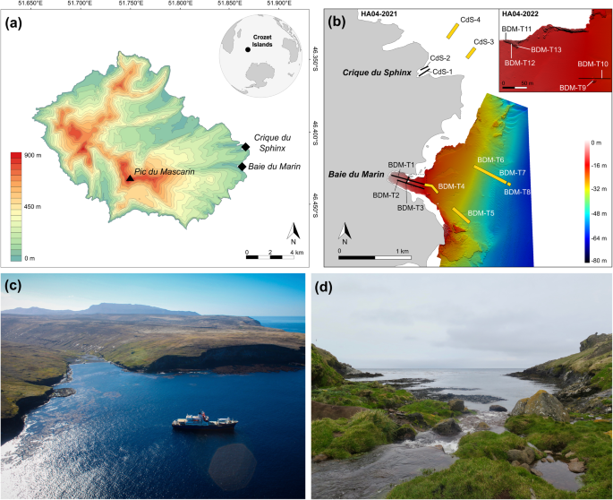
and functioning of Crozet benthic nearshore marine ecosystems, and opens new research avenues for sub-Antarctic ecological studies in general. METHODS STUDY AREAS Discovered in 1772 during
the expedition of the French explorer Marc Joseph Marion-Dufresne, the Crozet archipelago (45°48′S – 46°26′S; 50°14′E – 52°15′E) – located at 2,400 km north of the Antarctic Continent and
2,400 km southeast of South Africa – is composed of five small volcanic islands. These islands include, from west to east: _Île aux Cochons_, _Îlots des Apôtres_, _Île des Pingouins_, and
the two largest islands of the archipelago, _Île de la Possession and Île de l’Est_32. _Ile de la Possession_ (46°25′S; 51°45′E; Fig. 1a) – approximately 18 km wide by 15 km long, with a
total surface area of ~156 km2 – is the emerged part of a stratovolcano reaching an elevation of 934 m above sea level (a.s.l.) (_Pic du Mascarin_). Data presented here were acquired at two
sites located on the eastern coast of _Ile de la Possession_, at _Baie du Marin_ and _Crique du Sphinx_ (Fig. 1b). _Baie du Marin_ (BDM; 46°25′54″S; 51°52′11″E; Fig. 1c) is a narrow inlet of
c. 500 m length and 200 m width in its shallowest part (<20 m depth), and opens to the ocean in a larger embayment of about 2 km wide at 40 m depth. The coast is characterised by a rocky
shore with a sandy beach located at the back of the bay. The site is distinguished by an important colony of over 10,000 king penguins _Aptenodytes patagonicus_ (Miller, 1778) and elephant
seals _Mirounga leonina_ (Linnaeus, 1758), and harbours a rich benthic faunal and algal diversity12. _Crique du Sphinx_ (CdS; 46°25′08″S; 51°52′44″E; Fig. 1d) is located at 2 km to the north
of _Baie du Marin_ and opens northeastward as a small cove, spanning approximately 250 m long by 150 m width. Similarly at _Baie du Marin_, the coast is bordered by a rocky shore, with
however a small beach of pebbles and gravels. PROJECT BACKGROUND The site of _Baie du Marin_ is host to a hydroacoustic monitoring station (HA04) set up in December 2016 by the Preparatory
Commission for the Comprehensive Nuclear-Test-Ban Treaty Organization (CTBTO)31. Prior to the HA04 setting up, the Polar Environment Committee, which is consulted for every matter of
potential environmental relevance in the French Southern and Antarctic Territories (TAAF), recommended that an environmental survey was conducted and a baseline established for monitoring
the impact of the station setting up on marine habitats. TAAF awarded the Commission the “_concession for the utilization of the public maritime domain outside ports for the re−establishment
of hydroacoustic station HA04 in the Crozet archipelago in the French Austral and Antarctic Territories_” and required that the Commission be committed to support accompanying conservation
measures. TAAF and CTBTO made an agreement for “Nearshore Cable Inspection and Environmental Survey at IMS Hydroacoustic Station HA04 Crozet, France” (Contract No. 2021-0882) in September
2021. The first campaign took place in November 2021 for inspection of the HA04 station cable and environmental surveys of benthic nearshore habitats; and a second campaign was carried out
in November 2022. VIDEO-IMAGERY SET-UPS Benthic video surveys conducted in shallow waters (from 0 to 20 m depth) were performed using a multiple camera set-up (Fig. 2a,b) made of two
GoPro®HERO7 cameras with 80% field overlap, coupled with a Paralenz® Vaquita 2nd generation camera, all cameras being embedded in an epoxy resin plate. Both GoPro®HERO7 cameras were
waterproof with Front liquid-crystal display (LCD), 4 K video and 12-megapixel photos resolution (3840 × 2160 p), live streaming stabilization and a 128 GB card. The two GoPro®HERO7 cameras
were coupled with a waterproof underwater camera Paralenz® Vaquita 2nd generation (video output: 4K-30 fps; power sources: rechargeable Li-Po – 1600 mAh) equipped with depth and temperature
sensors. The lighting system consist of two high performance BigBlue® AL1300XWP lights (beam angle: 120°, 1300 lm; cold white colour (6500 K); power sources: rechargeable Li-Ion 18650
battery) placed next to each GoPro®HERO7 camera. The set-up was also equipped with three laser beams, two Innovam-Lasers® RLP-LG05-B150 red colour pointers (output power: <5 mW;
wavelength: λ = 635 nm; power sources: 2 × AA alkaline) and one BigBlue® green laser pointer (output power: <1 mW; wavelength: λ = 520 nm; power sources: 2 × AAA alkaline). Red lasers
were 10 cm apart in 2021, 15 cm in 2022 in order to estimate the filmed surface area. Video surveys were performed by scuba divers who maintained a regular swimming velocity, with the camera
oriented parallel to the sea bottom at an average distance of 50 cm. In deeper waters (from 20 to 60 m depth), video surveys were conducted using the Remotely Operated Vehicle (ROV) _SAAB
Seaeye Cougar-XT Compact_ (Fig. 2c,d). The ROV was equipped with a colour high-resolution OTAQ Eagle IPZ300™ camera (maximum resolution 1920 × 1080 (1080 P, 25 fps); 18x optical zoom) set
perpendicular to the seabed, and an oblique high-resolution black and white SAAB CAM06P rotating front camera. An Eeware® dimensional laser pointer set-up positioned perpendicular to the
seabed and forming an equilateral triangle with summits 7 cm apart was employed to estimate the filmed surface area. UNDERWATER IMAGERY COLLECTION Image acquisition was performed during _R/V
Marion Dufresne_ rotations OP03-2021 and OP03-2022. Operations were led by TAAF in response to contract No. 2021-0882 agreed with CTBTO for “Nearshore Cable Inspection and Environmental
Survey at IMS Hydroacoustic Station HA04 Crozet, France”, from 4th November to 9th November 2021, and from 23rd November to 24th November 2022, respectively. Throughout the HA04-Crozet-2021
campaign, twelve surveys were performed: eight at _Baie du Marin_ and four at _Crique du Sphinx_. At _Baie du Marin_, a first transect (BDM-T1) was performed along the submarine cables. A
second one (BDM-T2) was done 10 m apart to the south, and a third one (BDM-T3) was done across the bay starting from the center of the bay, at 10 m depth in direction of the northern coast.
In deeper waters, two ROV surveys were conducted along the submarine cables (BDM-T4 and BDM-T5, respectively), and two surveys in the northern part of the bay (BDM-T6 and BDM-T7). Finally,
an additional ROV survey was conducted at 60 m depth (BDM-T8). At _Crique du Sphinx_, two transects (CdS-T1 and CdS-T2) were performed by scuba divers along the cove; and two ROV surveys
were performed in the south (CdS-T3) and north (CdS-T4) of the cove. During the HA04-Crozet-2022 campaign, five video surveys were performed and focused on hard substrates (rocky bottoms and
submarine cables) in _Baie du Marin_ shallow waters. The first transect (BDM-T9) aimed to survey benthic communities located on the rock close to the submarine cables, at 19 m depth. The
second transect (BDM-T10) focused on the suspended section of submarine cables (as conducted also in the BDM-T1) to assess the potential influence of cables as substrate for benthic
communities. The following three transects (BDM-T11, BDM-T12 and BDM-T13) were carried out along the rocky shore in the north of the bay, approximately 200 m apart from submarine cables.
Benthic communities’ data on hard substrates in 2022 was completed by the image analysis of two transect sections conducted in 2021, encompassing BDM-T1x which represents the
suspended-cables section of the transect BDM-T1, and BDM-T3x which includes the rocky substrate from the BDM-T3 transect. Detailed information can be found in Lelièvre _et al_.12. Imagery
surveys were conducted in accordance with regulation rules of the French Southern and Antarctic Territories (TAAF) under permits A-2021-98 and A-2022-90 for field access, for
HA04-Crozet-2021 and HA04-Crozet-2022 oceanographic campaigns, respectively. DATA RECORDS To facilitate data download, each survey of the both oceanographic campaigns conducted at Crozet
(HA04-Crozet-2021 and HA04-Crozet-2022) has been individually deposited and is accessible on the dat@UBFC repository (https://doi.org/10.25666/DATAUBFC-2024-03-15)33. Detailed information
regarding each transect are provided in the metadata table deposited on the dat@UBFC repository. Survey folders include two main subfolders corresponding to (i) videos imagery metadata
(MOVI: Manually and remotely Operated VIdeo surveys); and (ii) images and benthic communities data (CROCO: CROzet COmmunities data and images). MOVI: MANUALLY AND REMOTELY OPERATED VIDEO
SURVEYS For imagery transects conducted during the HA04-Crozet-2021 campaign, scuba surveys (BDM-T1 to BDM-T3; CdS-T1 and CdS-T2) folders includes two additional folders, GoPro®HERO7
(further divided into GoPro®HERO7 LEFT camera and GoPro®HERO7 RIGHT camera) and Paralenz® Vaquita; and surveys carried out using the ROV (BDM-T4 to BDM-T8; CdS-T3 and CdS-T4) includes two
folders with video transects of the OTAQ Eagle IPZ300™ camera and of the B&W SAAB CAM06P camera (Fig. 3a). However, surveys collected during the HA04-Crozet-2022 campaign (BDM-T9 to
BDM-T13) contains two subfolders: GoPro®HERO7 (further divided into GoPro®HERO7 LEFT camera and GoPro®HERO7 RIGHT camera) and Paralenz® Vaquita (Fig. 3a). Video surveys in the archives have
the following format: <site-survey ID>_<camera ID-sequence ID>_<year>.<format> All video surveys have a filename starting with the string: <site-survey ID>,
where site name is either BDM (standing for _Baie du Marin_) or CdS (standing for _Crique du Sphinx_), and survey ID starts with letter T for “Transect” followed by a figure comprised
between 1 and 13 for _Baie du Marin_, and between 1 and 4 for _Crique du Sphinx_. The string <camera ID-sequence number> is composed of the camera ID that identifies the camera type
used for image acquisition, including GPL (GoPro®HERO7 LEFT camera), GPR (GoPro®HERO7 RIGHT camera), P (Paralenz® Vaquita camera) and B&W (black and white SAAB CAM06P camera); and the
sequence ID which is a figure varying from 1 to 12 depending on the transect. The string <year> corresponds to the year of the oceanographic campaign, either 2021 or 2022. Finally, the
string <format> is for the format of video sequences, which are all in MPEG-4 (mp4). For example, video imagery BDM-T7_B&W-2_2021 corresponds to transect 7 performed at _Baie du
Marin_, sequence 2 of video surveys recorded with the ROV black and white SAAB CAM06P camera during the HA04-Crozet-2021 oceanographic cruise. CROCO: CROZET COMMUNITIES DATA AND IMAGES With
the exception of BDM-T1x and BDM-T3x transect sections, still images were equally extracted from videos, at a pace of one image every 5 m along the transect, for each survey of the
HA04-Crozet-2021 campaign34. However, transects conducted during HA04-Crozet-2022 campaign as well as BDM-T1x and BDM-T3x transect sections were totally cut into still images12. Images were
manually extracted from video-transects using the _VLC media player version 3.0.16_ (VideoLAN Organization, Paris, France) software, taking care to avoid overlap and out-of-focus images.
Overall, a total of 755 images (670 images for HA04-Crozet-2021; and 85 images for HA04-Crozet-2022) were manually annotated using the online open-source software BIIGLE 2.0 (_Benthic Image
Indexing and Graphical Labelling Environment_)35. Identification of faunal and algal taxa was performed at the lowest taxonomic level possible in collaboration with taxonomists. This process
involved (i) reviewing the images analysed in BIIGLE 2.0 using the _LARGO_ tool, which enables a comparison of annotations for a specific taxa, and (ii) submitting collected samples and
macro-photography pictures captured during transect imaging acquisition to taxonomists. For each image and each taxon, faunal organisms were counted, and algae surface covers were measured
by delineating each one on calibrated images. These biological data were obtained using only one of the two GoPro®HERO7 cameras for benthic surveys conducted in shallow waters, and from the
colour high-resolution OTAQ Eagle IPZ300™ camera in deeper waters. Within each transect folder, CROCO (Fig. 3b) contains: (i) Benthic Communities Raw Data with two files: faunal abundance
data and algal surface cover for each image of the corresponding transect; and (ii) Transect Images used for quantifying faunal abundance and algal surface cover (Fig. 4). File names in the
Benthic Communities Raw Data archive have the following format: <site-survey ID>_<organism-measurement>_<year>.<format> Filenames start with the string
<site-survey ID> where site is either BDM (_Baie du Marin_) or CdS (_Crique du Sphinx_), and survey ID starts with letter T for “Transect” followed by a figure varying between 1 and 13
for _Baie du Marin_, and between 1 and 4 for _Crique du Sphinx_. The string <organism-measurement> designates the type of organism present in images and associated data (Algal-Cover
or Faunal-Abundance data). The string <year> corresponds to the year of the oceanographic campaign, either 2021 or 2022. Finally, the string <format> indicates the file format,
either an Excel (.xls) or Comma-Separated Text file (.csv). For example, benthic data CdS-T1_Faunal-Abundance_2021 corresponds to transect 1 performed at _Crique du Sphinx_, faunal abundance
counted on analysed images of the transect, during the HA04-Crozet-2021 oceanographic cruise. Data files have the following, standardized format: image identification, temperature data,
depth, image area (computed based on the known distance between laser pointers), habitat type (categorized as sand, sand-cable, sand-pebbles, sand-pebbles-cable, pebbles, suspended-cables,
and rock), and a varying number of columns corresponding to either abundance (fauna) or cover (algae) data for each taxa identified along the video-transect. Latitude and longitude of ROV
images (BDM-T4 to BDM-T8 as well as CdS-T3 and CdS-T4) are also provided for the HA04 Crozet 2021 survey. Temperature data are missing for ROV transects, but point-based measurements
performed in the field indicate a narrow range of 4.8 to 5 °C. With the exception of BDM-T8 and CdS-T3 surveys, algal cover data was not observed along ROV transects. TECHNICAL VALIDATION
Overall, a total of 755 images were manually analysed, comprising 52 faunal (representing 20,709 annotations) and 14 algal taxa identified in 2021 as well as 45 faunal (representing 28,015
annotations) and 14 algal taxa identified in 2022. Quality of datasets was checked through a detailed analysis of the structural and functional diversity of benthic communities associated
with hard substrates using both a part of the HA04-Crozet-2021 dataset and the complete HA04-Crozet-2022 video dataset12. Taxonomic identification, species abundance data at the transect
scale as well as species functional traits were made available in Lelièvre _et al_.12. In addition, a characterisation of coastal habitats and benthic communities was conducted from
video-imagery surveys of the HA04-Crozet-2021 dataset34. Finally, video surveys from HA04-Crozet-2021 were proved reliable to characterize local fine-scale hydrodynamic processes occurring
along the eastern coast of _Ile de la Possession_ based on bedforms analysis36. USAGE NOTES RECOMMENDATIONS FOR VIDEO-IMAGERY MANUAL PROCESSING We suggest using the online open-source
platform BIIGLE 2.0 (_Benthic Image Indexing and Graphical Labelling Environment_)35 to analyse still images and video-datasets. BIIGLE 2.0 was developed for annotating the benthic fauna
from marine image collections using customized tools that make manual annotation efficient and effective35. BIIGLE 2.0 offers the following advantages: (i) a user-friendly interface to
annotate images or videos with specific labels (e.g., algae cover, species abundance); (ii) an automatic storage of images, labels and annotations on a central server allowing collaborative
studies between researchers and taxonomists. According to the invited member status (either guest, editor or admin; access authorization being provided by the administrator user), users may
have the permission to add or edit annotations entered in the project; (iii) a standardised data export containing expert labels into a single Excel sheet; and finally, (iv) a high quality
technical support that contributes to a positive user experience. In addition, a few recommendations may be useful to ensure data quality and validity control when manually processing
benthic imagery data: * 1) To optimize video-imagery annotations and analysis, we advocate an initial “_observer calibration_” training period for users to get familiar with their case
study. User knowledge may improve during the annotating process contributing to an increased reliability of observers’ analyses37. White _et al_.38 suggests that 10% of data should be
devoted to the training process, for which we recommend using a random set of video-imagery. * 2) To minimize or avoid interrelated observations and maintain a constant level of observer
attention over time, we recommend processing images in a random order. Observer fatigue leads to a decrease in cognitive performance during imagery analysis after 60 minutes39. To preserve
data accuracy, we recommend a 5-minute break every hour. * 3) We advise observers to alternately analyse still images and the corresponding video sequences to optimize annotation quality
(e.g., species identification, species abundance). In the case of faunal communities studies, several factors including high densities, overlapping between individuals and camouflage by
algae may complicate data processing from still images. We thus recommend the use of video sequences, alternately read in backward and forward modes to enhance annotation precision.
INFORMATION ON ROV IMAGERY AND BENTHIC COMMUNITIES’ DATA We recommend users to pay close attention to directional values displayed on the compass of images from the black and white SAAB
CAM06P front camera equipped on the ROV (HA04-Crozet-2021). When comparing compass values with the known cable position, it appeared that the compass is out by about 50 degrees. We also
inform users about recording issues from 06:04:09 to 06:09:59 on the B&W SAAB CAM06P front camera for transect BDM-T5, and from 12:37:55 to 12:49:33 for the B&W SAAB CAM06P front
camera for transect BDM-T6. Similarly, we would like to notify users about missing data (NA) in three faunal abundance files within the HA04-Crozet-2021 dataset, BDM-T4
(BDM-T4_Image-39_2021, BDM-T4_Image-43_2021 and BDM-T4_Image-46_2021), BDM-T7 (BDM-T7_Image-25_2021 and BDM-T7_Image-26_2021), as well as CdS-T4 (from CdS-T4_Image-51_2021 to
CdS-T4_Image-54_2021). DATA SHARING AND FUTURE BENTHIC RESEARCHES The commitment of the French Southern and Antarctic Territories (TAAF) and Biogéosciences Research Unit (CNRS, _Université
de Bourgogne_) to share MEDUSA is intended to foster collaborative initiatives in the community of marine ecologists to improve understanding of the functioning of sub-Antarctic ecosystems
and address environmental challenges these unique vulnerable environments are confronted with. The provided data are also intended to help decision-makers to shape effective conservation
policies for the preservation and sustainable management of these unique environments. CODE AVAILABILITY Faunal abundance and algal surface cover datasets were obtained by using the online
software BIIGLE 2.0 (_Benthic Image Indexing and Graphical Labelling Environment_)35. REFERENCES * Turner, J. _et al_. Antarctic climate change and the environment: an update. _Polar Rec.
(Gr. Brit)._ 50, 237–259 (2014). Article Google Scholar * Wang, G. _et al_. Future Southern Ocean warming linked to projected ENSO variability. _Nat. Clim. Chang._ 12, 649–654 (2022).
Article ADS CAS Google Scholar * Sallée, J. B. Southern Ocean warming. _Oceanography_ 31, 52–62 (2018). Article Google Scholar * Azarian, C., Bopp, L., Pietri, A., Sallée, J. B. &
d’Ovidio, F. Current and projected patterns of warming and marine heatwaves in the Southern Indian Ocean. _Prog. Oceanogr._ 215, 103036 (2023). Article Google Scholar * Nel, W., Hedding,
D. W. & Rudolph, E. M. The sub-Antarctic islands are increasingly warming in the 21st century. _Antarct. Sci._ 35, 124–126 (2023). Article ADS Google Scholar * Gille, S. T. Warming of
the Southern Ocean since the 1950s. _Science._ 295, 1275–1277 (2002). Article ADS CAS PubMed Google Scholar * Mélice, J. L., Lutjeharms, J. R. E., Rouault, M. & Ansorge, I. J.
Sea-surface temperatures at the sub-Antarctic islands Marion and Gough during the past 50 years. _S. Afr. J. Sci._ 99, 363–366 (2003). Google Scholar * Auger, M., Morrow, R., Kestenare, E.,
Sallée, J. B. & Cowley, R. Southern Ocean _in-situ_ temperature trends over 25 years emerge from interannual variability. _Nat. Commun._ 12, 1–9 (2021). Google Scholar * McNeil, B. I.
& Matear, R. J. Southern Ocean acidification: a tipping point at 450-ppm atmospheric CO2. _Proc. Natl. Acad. Sci. USA_ 105, 18860–18864 (2008). Article ADS CAS PubMed PubMed Central
Google Scholar * Turner, J. _et al_. Non-annular atmospheric circulation change induced by stratospheric ozone depletion and its role in the recent increase of Antarctic sea ice extent.
_Geophys. Res. Lett._ 36, 1–5 (2009). Article Google Scholar * Blanchard-Wrigglesworth, E., Roach, L. A., Donohoe, A. & Ding, Q. Impact of winds and Southern Ocean SSTs on Antarctic
aea ice trends and variability. _J. Clim._ 34, 949–965 (2021). Article ADS Google Scholar * Lelièvre, Y. _et al_. Taxonomic and functional diversity of subtidal benthic communities
associated with hard substrates at Crozet archipelago (sub-Antarctic, Southern Ocean). _Front. Mar. Sci._ 10, 1291038 (2023). Article Google Scholar * von der Meden, C. E. O. _et al_.
Long-term change in epibenthic assemblages at the Prince Edward Islands: a comparison between 1988 and 2013. _Polar Biol._ 40, 2171–2185 (2017). Article Google Scholar * Seitz, R. D.,
Wennhage, H., Bergström, U., Lipcius, R. N. & Ysebaert, T. Ecological value of coastal habitats for commercially and ecologically important species. _ICES J. Mar. Sci._ 71, 648–665
(2014). Article Google Scholar * Henseler, C. _et al_. Coastal habitats and their importance for the diversity of benthic communities: a species- and trait-based approach. _Estuar. Coast.
Shelf Sci_. 226 (2019). * Törnroos, A., Nordström, M. C. & Bonsdorff, E. Coastal habitats as surrogates for taxonomic, functional and trophic structures of benthic faunal communities.
_PLoS One_ 8, 1–14 (2013). Article Google Scholar * Hewitt, J. E., Thrush, S. F. & Dayton, P. D. Habitat variation, species diversity and ecological functioning in a marine system. _J.
Exp. Mar. Bio. Ecol._ 366, 116–122 (2008). Article Google Scholar * Friedlander, A. M. _et al_. Patterns and drivers of benthic macroinvertebrate assemblages in the kelp forests of
southern Patagonia. _PLoS One_ 18, 1–17 (2023). Article Google Scholar * Clark, G. F. _et al_. Nearshore marine communities at three New Zealand sub-Antarctic islands. _Polar Biol._ 42,
2193–2203 (2019). Article Google Scholar * Freeman, D., Cooper, S., Funnell, G. & Neale, D. Nearshore benthic community structure at the Bounty and Antipodes Islands, Subantarctic New
Zealand. _Polar Biol._ 34, 1485–1499 (2011). Article Google Scholar * Barnes, D. K. A. _et al_. Shallow benthic fauna communities of South Georgia Island. _Polar Biol._ 29, 223–228 (2006).
Article Google Scholar * Branch, G. M., Attwood, C. G., Gianakouras, D. & Branch, M. L. Patterns in the benthic communities on the shelf of the sub-Antarctic Prince Edward Islands.
_Polar Biol._ 13, 23–34 (1993). Article Google Scholar * Féral, J.-P. _et al_. The marine vegetation of the Kerguelen Islands: history of scientific campaigns, inventory of the flora and
first analysis of its biogeographical affinities. _Cryptogam. Algol_. 173–216 (2021). * Teixidó, N., Garrabou, J. & Harmelin, J. G. Low dynamics, high longevity and persistence of
sessile structural species dwelling on mediterranean coralligenous outcrops. _PLoS One_ 6, e23744 (2011). Article ADS PubMed PubMed Central Google Scholar * Smale, D. A. & Barnes,
D. K. A. Likely responses of the Antarctic benthos to climate-related changes in physical disturbance during the 21st century, based primarily on evidence from the West Antarctic Peninsula
region. _Ecography (Cop.)._ 31, 289–305 (2008). Article ADS Google Scholar * Teixidó, N., Garrabou, J., Gutt, J. & Arntz, W. E. Recovery in Antarctic benthos after iceberg
disturbance: trends in benthic composition, abundance and growth forms. _Mar. Ecol. Prog. Ser._ 278, 1–16 (2004). Article ADS Google Scholar * Robinson, B. J. O., Barnes, D. K. A.,
Grange, L. J. & Morley, S. A. The extremes of disturbance reduce functional redundancy: functional trait assessment of the shallow Antarctic benthos. _Front. Mar. Sci._ 8, 1–12 (2022).
Article Google Scholar * Bravo, G. _et al_. Roving diver survey as a rapid and cost-effective methodology to register species richness in sub-Antarctic kelp forests. _Diversity_ 15, 354
(2023). Article Google Scholar * Solan, M. _et al_. Towards a greater understanding of pattern, scale and process in marine benthic systems: a picture is worth a thousand worms. _J. Exp.
Mar. Bio. Ecol._ 285–286, 313–338 (2003). Article Google Scholar * Jamieson, A. J., Boorman, B. & Jones, D. O. B. Deep-sea benthic sampling. in _Methods for the study of marine
benthos_ 285–347 (2013). * Bauer, S. & O’Reilly, C. The Comprehensive Nuclear-Test-Ban Treaty Organization (CTBTO): current and future role in the verification regime of the
nuclear-test-Ban Treaty. in _Nuclear Non-Proliferation in International Law: Volume II - Verification and Compliance_ 131–150 (2016). * Chevallier, L., Nougier, J. & Cantagrel, J. M.
Volcanology of Possession island, Crozet archipelago (TAAF). in _Antarctic Earth Science, 4th International Symposium_ 652–658 (1983). * Lelièvre, Y. _et al_. MEDUSA: Marine benthic
Ecological Data from Underwater imagery Surveys of sub-Antarctic Crozet environments. _dataUBFC_ https://doi.org/10.25666/DATAUBFC-2024-03-15 (2024). * Lelièvre, Y., Le Gall, L., Dubois, P.
& Saucède, T. Characterisation of coastal habitats and marine benthic communities of the sub-Antarctic Crozet archipelago using underwater imagery. _submitted_ (2024). * Langenkämper,
D., Zurowietz, M., Schoening, T. & Nattkemper, T. W. BIIGLE 2.0 - Browsing and annotating large marine image collections. _Front. Mar. Sci._ 4, 1–10 (2017). Article Google Scholar *
Lelièvre, Y. _et al_. Can we infer coastal hydrodynamics from bedform patterns and sediment properties? A case study from the sub-Antarctic Crozet archipelago. _submitted_ (2024). * Howell,
K. L., Bullimore, R. D. & Foster, N. L. _Quality assurance in the identification of deep-sea taxa from video and image analysis: response to Henry and Roberts_. 71, 899–906 (2014). *
White, J. _et al_. Seafloor video mapping: collection, analysis and interpretation of seafloor video footage for the purpose of habitat classification and mapping. MESH Video Working Group
Report (2007). * Schoening, T., Osterloff, J. & Nattkemper, T. W. RecoMIA—Recommendations for Marine Image Annotation: lessons learned and future directions. _Front. Mar. Sci_. 3 (2016).
Download references ACKNOWLEDGEMENTS This research activity is a contribution to project No. 2021-0882 “Nearshore Cable Inspection and Environmental Survey at IMS Hydroacoustic Station HA04
Crozet, France” conducted by the TAAF in response to the CTBTO solicitation, and to the French Polar Institute Paul-Émile-Victor (IPEV) project #1044 Proteker. The authors would like to
acknowledge the captains and crews of the _R/V Marion Dufresne II_ and the ROV operating team for their assistance in the field. We are also particularly grateful to the staffs and scuba
divers of the French Polar Institute and TAAF: L. Le Gall, Y. Sabathé, S. Sémelin, and M.-F. Bernard. Authors are particularly grateful to all taxonomists who have contributed to species
identification: R. Downey (Porifera), M. Mackenzie (Holothuroidea), C.J. Sands and T. O’Hara (Ophiuroidea), M. Capa, N. Lavesque and S. Hourdez (Polychaeta), M. Tatián (Ascidiacea), C.
Moreau and Q. Jossart (Asteroidea), S. Rosenfeld (Gastropoda), H. Wägele (Nudibranchia), and L. Le Gall (Algae). We especially thank D. Champagnac (_Biogéosciences_, _Université de
Bourgogne_) for the design conception of the image acquisition device and his technical assistance. The authors also thank M. Zampolli and G. Haralabus from the CTBTO for their helpful
comments and productive discussions throughout the project. We thank J. Pergaud (_Biogéosciences_, _Université de Bourgogne_) and the dat@UBFC team for their assistance in the data
deposition. Yann Lelièvre was supported by TAAF-UB convention #2258. Philippe Dubois is a Research Director of the National Fund for Scientific Research (Belgium). AUTHOR INFORMATION AUTHORS
AND AFFILIATIONS * Biogéosciences, UMR 6282 CNRS, Université de Bourgogne, 6 Boulevard Gabriel, 21000, Dijon, France Yann Lelièvre, Sébastien Motreuil, Léa Specq & Thomas Saucède *
IMBE-Institut Méditerranéen de Biologie et d’Ecologie marine et continentale, UMR 7263 Aix Marseille Université/CNRS/IRD/UAPV, Station Marine d’Endoume, Chemin de la Batterie des Lions,
13007, Marseille, France Christian Marschal * Laboratoire de Biologie marine, Université Libre de Bruxelles, Avenue F.D. Roosevelt 50, CP160/15, 1050, Bruxelles, Belgium Philippe Dubois *
Direction de l’Environnement, Terres australes et antarctiques françaises, Rue Gabriel Dejean, 97410, Saint-Pierre, La Réunion, France Lisa Wauters & Mathilde Guéné Authors * Yann
Lelièvre View author publications You can also search for this author inPubMed Google Scholar * Sébastien Motreuil View author publications You can also search for this author inPubMed
Google Scholar * Léa Specq View author publications You can also search for this author inPubMed Google Scholar * Christian Marschal View author publications You can also search for this
author inPubMed Google Scholar * Philippe Dubois View author publications You can also search for this author inPubMed Google Scholar * Lisa Wauters View author publications You can also
search for this author inPubMed Google Scholar * Mathilde Guéné View author publications You can also search for this author inPubMed Google Scholar * Thomas Saucède View author publications
You can also search for this author inPubMed Google Scholar CONTRIBUTIONS Y.L. was the primary coordinator and author of the manuscript, and collated the datasets. Y.L. and T.S. conceived
the research project and the video-imagery sampling design. T.S. and S.M. contributed to the funding acquisition, field campaigns and supervised the research project. S.M., C.M., P.D., L.W.,
M.G. and T.S. took part in the video acquisition either by SCUBA diving or with the R.O.V. Y.L. and L.S. have acquired benthic communities’ data from video-imagery. All authors contributed
to the writing process and revised the manuscript. CORRESPONDING AUTHOR Correspondence to Yann Lelièvre. ETHICS DECLARATIONS COMPETING INTERESTS The authors declare no competing interests.
ADDITIONAL INFORMATION PUBLISHER’S NOTE Springer Nature remains neutral with regard to jurisdictional claims in published maps and institutional affiliations. RIGHTS AND PERMISSIONS OPEN
ACCESS This article is licensed under a Creative Commons Attribution 4.0 International License, which permits use, sharing, adaptation, distribution and reproduction in any medium or format,
as long as you give appropriate credit to the original author(s) and the source, provide a link to the Creative Commons licence, and indicate if changes were made. The images or other third
party material in this article are included in the article’s Creative Commons licence, unless indicated otherwise in a credit line to the material. If material is not included in the
article’s Creative Commons licence and your intended use is not permitted by statutory regulation or exceeds the permitted use, you will need to obtain permission directly from the copyright
holder. To view a copy of this licence, visit http://creativecommons.org/licenses/by/4.0/. Reprints and permissions ABOUT THIS ARTICLE CITE THIS ARTICLE Lelièvre, Y., Motreuil, S., Specq,
L. _et al._ MEDUSA: Marine benthic Ecological Data from Underwater imagery Surveys of sub-Antarctic Crozet environments. _Sci Data_ 11, 613 (2024). https://doi.org/10.1038/s41597-024-03460-4
Download citation * Received: 15 April 2024 * Accepted: 31 May 2024 * Published: 12 June 2024 * DOI: https://doi.org/10.1038/s41597-024-03460-4 SHARE THIS ARTICLE Anyone you share the
following link with will be able to read this content: Get shareable link Sorry, a shareable link is not currently available for this article. Copy to clipboard Provided by the Springer
Nature SharedIt content-sharing initiative