- Select a language for the TTS:
- UK English Female
- UK English Male
- US English Female
- US English Male
- Australian Female
- Australian Male
- Language selected: (auto detect) - EN
Play all audios:
ABSTRACT Fluvial erosion is usually assumed to be absent on Venus, precluded by a high surface temperature of ~450 °C and supported by extensive uneroded volcanic flows. However, recent
global circulation models suggest the possibility of Earth-like climatic conditions on Venus for much of its earlier history, prior to catastrophic runaway greenhouse warming. We observe
that the stratigraphically oldest, geologically most complex units, tesserae, exhibit valley patterns morphologically similar to the patterns resulting from fluvial erosion on Earth. Given
poor topographic resolution, we use an indirect technique to recognize valleys, based on the pattern of lava flooding of tesserae margins by adjacent plains volcanism. These observed valley
patterns are attributed to primary geology, tectonic deformation, followed by fluvial erosion (and lesser wind erosion). This proposed fluvial erosion in tesserae provides support for
climate models for a cool, wet climate on early Venus and could be an attractive research theme for future Venus missions. SIMILAR CONTENT BEING VIEWED BY OTHERS EARTH-LIKE LITHOSPHERIC
THICKNESS AND HEAT FLOW ON VENUS CONSISTENT WITH ACTIVE RIFTING Article 14 November 2022 THE SUBMERGED FOOTPRINT OF PERITO MORENO GLACIER Article Open access 02 October 2020 VALLEY FORMATION
ON EARLY MARS BY SUBGLACIAL AND FLUVIAL EROSION Article 03 August 2020 INTRODUCTION Venus is commonly referred to as Earth’s sister planet because of the proximity of the two in the Solar
System and their similarities in size, mass, density, composition, and surface gravity. In contrast to Earth, however, Venus today exhibits a lack of plate tectonics and boasts high surface
temperatures (~450 °C) and a dense CO2-dominated atmosphere1. The most detailed radar image data for Venus were provided by NASA’s 1990–1994 Magellan mission, which collected multiple
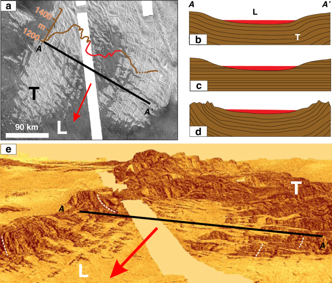
datasets including high-resolution (~100 m/pixel) images of 98% of the planet’s surface using Synthetic Aperture Radar (SAR) and altimetry data2. Tesserae (Fig. 1a, e) are tectonically
complex units that occupy ~8% of the surface of Venus, commonly occurring as high-standing crustal plateaus that are embayed by lava flows from the adjacent volcanic plains. Tesserae are
inferred from superposition relationships to be the oldest regions on the planet3,4,5,6. The nature of the pre-deformation terrain, including mode of emplacement, and whether tesserae
compositions are mafic or felsic, as well as the causes and timing of deformation, remain unclear3,4,5,6. The current high temperatures (450 °C) and pressures (9 MPa) on Venus are generally
interpreted to mean that the surface of Venus does not display evidence for extensive erosion7, which is convincingly true for stratigraphically younger lobate flows that exhibit simple
superposition of flow units and have radar backscatter properties consistent with primary flow morphology and rheology8,9. Additional surface features such as contractional structures called
wrinkle ridges10,11, graben–fissure systems12,13, and lava channels (including canali and sinuous rilles)14,15,16,17,18,19,20 all have significant topographic signatures that can be
partially obscured or removed by subsequent erosion. A fluvial rather than volcanic origin for canali has been considered16,17, but is generally rejected on the basis of the absence of
flowing water due to the high atmospheric temperatures16,20. Impact craters in volcanic plains areas are mostly pristine except where affected by younger volcanism21,22. These observations
imply a lack of fluvial erosion on Venus, consistent with the planet’s current high surface temperature. Recent modelling, however, suggests a re-consideration of whether flowing water has
modified the stratigraphically oldest units, tesserae. A global circulation model for Venus suggests that Earth-like conditions could have existed for most of Venusian history, and that a
runaway greenhouse effect changed Venus’ climate catastrophically and led to loss of water23,24,25,26. The cause of this greenhouse effect is typically linked to CO2 degassing during major
volcanic eruptions, the timing and duration of which are the subject of debate, ranging from a catastrophic, global volcanic resurfacing event to steady-state resurfacing, yielding mean
surface age estimates of ~750 to 150 Ma21,27,28. As tesserae predate the widespread mafic plains volcanism linked to this proposed resurfacing, they may have formed prior to runaway
greenhouse warming. If these enigmatic surface units do date from before Venus’ climate catastrophe, then a detailed assessment of their morphology might allow evaluation of whether they
formed under climatic conditions where liquid water was present on Venus and fluvial erosion could occur. A clear signal of water erosion would be the recognition of fluvial valley systems.
The first hurdle to recognizing tesserae erosion is the uncertainties in Magellan altimetry topographic data, which have vertical and horizontal resolutions of approximately 50–100 m and
10–20 km, respectively29,30,31. Higher-resolution stereo topographic maps produced from combining Cycles 1, 2, and Cycle 3 Magellan SAR data4,31,32 offer an improved horizontal resolution of
1–2 km, but such data are only available for only 20% of the planet31. Here we have taken a different and unambiguous proxy approach to identify paleo-valleys within tesserae. We consider
only those portions of tesserae, typically their margins, which are partially flooded by younger lava flows fed from the surrounding plains (Fig. 1a). The lava flooding represents an
original semi-horizontal surface that readily discriminates areas of higher elevation from paleo-valleys. Even in cases where subsequent local later uplift occurred (affecting both tessera
and embayed younger lava flows), the paleo-valley patterns would still be reliably revealed by the flows embaying the tesserae. On Earth, flooded fjords, nunataks, and yardangs are
conceptually similar to lava flooding where liquid water is the reference semi-horizontal surface for flooded fiords (Fig. 2b), ice for nunataks (Fig. 2c), and sand for yardangs (Fig. 2d).
Comparison of paleo-valley patterns with terrestrial stream valley types suggests that fluvial erosion may have affected the old tesserae terrain in support of models for more Earth-like
conditions in Venus’s earlier history. This hypothesis can be fully tested with higher-resolution data from future Venus missions. RESULTS COMBINED TECTONICS AND FLUVIAL EROSION The eight
tesserae regions of this study (Fig. 3)33 are located in Venusian quadrangles V-33, V-34, V-12, and V-4. Quadrangles V-33, V-34, and V-12 are currently unmapped and the northernmost portion
of Fig. 3g, h are in mapped quadrangle V-434. Given their tectonic complexity, the geological mapping of tesserae (including in Quadrangle V-4) has naturally focussed on structural mapping
(such as folds and faults) with limited lithological mapping (apart from distinguishing areas of intra-tesserae plains units); published maps have mostly been shaped by the standard implicit
assumption in the literature (e.g., refs. 4,5,6,27) that tesserae did not experience erosion. This viewpoint requires all changes in surface topography to solely reflect tectonic processes,
such as folding and faulting (Fig. 1b). From a purely tectonic perspective, the tessera paleo-valley pattern in Fig. 1 should be interpreted as a broad synclinal flexural fold with a
wavelength of 120 km flooded by lava and flanked by anticlines in the tesserae on east and west sides (Fig. 1b). An alternative but again purely tectonic interpretation would be a
fault-bound rift with a width of 30–50 km. However, the volcanic-flooding pattern (Fig. 1e) does not delineate a simple down-dropped crustal block (a rift), and there is no obvious
continuation of rift structures outside the area of volcanic flooding to the NNE (north-northeast); such features should be obvious in the absence of erosion. Two other possible geological
interpretations are pure erosion of layered stratigraphy (Fig. 1c) and a combination of synclinal folding followed by erosion (Fig. 1d). The basin-parallel lineament sets in the tessera
hills on the east and west flanks of the valley appear to belong to faintly visible surfaces that are inward dipping toward the synclinal axis (Fig. 1e; see white dashed lines) and appear to
be inconsistent with either pure tectonic deformation (Fig. 1b) or pure erosion (Fig. 1c) models. The simpler interpretation (acknowledging the limits of image and topographic resolution)
is development of synclinal fold plunging to the south (direction of arrow) followed by extensive fluvial erosion (Fig. 1a) to produce a widened valley and topographically subdued small
tesserae inliers within that valley. It is noteworthy that given the 20× vertical exaggeration in Fig. 1e, which the steeply dipping surfaces implied by the lineaments, would correspond to
significantly shallower true dips; for instance, an apparent 80° dip in Fig. 1e would correspond to a true dip of 15°. Building on these observations, additional areas of tesserae are
considered for evidence of fluvial erosion (Figs. 3 and 4). SAR images of selected areas (Fig. 3) allow paleo-valley patterns to be mapped and compared with types of stream drainage patterns
on Earth35,36 (left sketch). Elevated oblique three-dimensional views (Figs. 1e and 4) of each of these regions in Fig. 3 were generated from SAR images draped on the Magellan altimetry
topography; these provide visual support for the interpretation that younger lava flows mark paleo-valleys in tesserae margins. Additional oblique views were generated (Supplementary Fig. 1)
by draping the SAR images on the stereo-topography data31. Lava flooding will preferentially fill major valleys near the tessera margins and will less reliably flood the valley networks
further inland and upslope within the tesserae. While recognizing this limitation of the proxy approach, it is notable that the mapped tessera valley patterns in Figs. 3 and 4 are
morphologically similar to five of the six recognized terrestrial stream drainage patterns35,36, which include trellis, radial, parallel, rectangular, and more speculatively dendritic
(leaving only the annular pattern unrecognized). The morphological and scale similarities between these candidate tessera paleo-valley patterns and stream drainage patterns on Earth are
consistent with a scenario under which fluvial erosion contributed to shaping tessera topography—which likely had already been affected to some degree by earlier folding and faulting
tectonics. A further example of interpreted fluvial erosion is offered in Fig. 5, where a kipuka that we interpret as a tear-drop-shaped island is present in a lava-flooded valley within a
tessera. The tear-drop geometry suggests fluid flow from west to east. Terrestrial stream drainage patterns are controlled by rock properties and slopes35,36,37 and thus the type of stream
drainage pattern that best matches the flooded geometries within a particular tessera could be indicative of control by local geology. As a generalization, radial, parallel, and dendritic
patterns are formed on slopes underlain by homogenous material, although parallel patterns can also reflect steep layered sequences with resistant and weak beds alternating. Trellis and
rectangular patterns can be caused by dipping sedimentary strata of unequal resistance to erosion, by dipping volcanic flows with differential erosion between the upper and lower portions of
flow, and/or by orthogonal pre-existing fracture patterns. Radial patterns develop on topographic domes or basins composed of homogenous material. For each example in Fig. 3, we consider
both a tectonic and fluvial erosion interpretation, and favour a combination of initial tectonics followed by erosion. As mentioned above, the pattern in Fig. 3a (cf. Fig. 1) is consistent
with a NNE–SSW (north-northeast - south-southwest)-trending plunging syncline (shown by the direction of arrow) that has been widened by erosion. The edge of a layered (possibly
volcano-sedimentary?) sequence is exposed on the eastern and western flanks of the basin (apparently steep but given the vertical exaggeration the true dip may only be 10 s of degrees). The
radiating pattern in Fig. 3b (see Fig. 4a) has previously been inferred to represent a valley network caused by lava flows (Fig. 4 in ref. 18) and this interpretation could be consistent
with subsequent lava flows filling older valleys that had been generated by fluvial erosion. However, in detail this pattern is complicated and is consistent with radial drainage in some
places, but not in others. One explanation is that the there was significant tectonic modification after the creation of the radial drainage system but before lava emplacement. The pattern
in Fig. 3c (see also Fig. 4b, c) could be interpreted as a series of parallel ENE (east-northeast)-trending graben or as an anticlinal–synclinal sequence with a fold spacing of 4–10 km
followed by erosion. The flooded tessera pattern in Fig. 3d has some resemblance to orthogonal jointing in uplifted plateaus of uniform rock, or to chocolate tablet boudinage structures38
subsequently exhumed by erosion. We interpret the flooded pattern in Fig. 3e (as well as Fig. 4e, f) as having been controlled by two tectonic trends: a NNW–SSE-trending rift and a set of
perpendicular, ENE–WSW (east-northeast - west-southwest)-trending geological lineaments, with all features widened by subsequent erosion. Figure 3f (see also Fig. 4g) can be interpreted as
layered stratigraphy dipping to the ENE and exposed by erosion (cf. ref. 39). Figure 3g (see also Fig. 4h) can be interpreted as planar surfaces associated with two sets of orthogonal
lineament sets of uncertain origin (northwest- and northeast-trending) that have, again, been widened by erosion. Figure 3h (see also Fig. 4i) shows complicated primary geology with multiple
trends of curving and straight lineaments of uncertain origin and uncertain dip widened by erosion and later filled by lava. The variable topography suggests subsequent uplift, but in this
case the lava flows would preserve the paleo-valley pattern that was present when those lava flows were emplaced. It is important to note that the width of lava flooding in the proposed
tesserae valleys (up to >50 km) should not be interpreted as equalling the width of the postulated river systems. Depending on their accumulated thickness, the infilling lava flows could
fill the valleys to a level that obscures the details of the past fluvial system beneath and prevents quantitative morphological analysis of the valley patterns, which could include,
meandering rivers, mega-floods, and even glaciation. Terrestrial river systems (and similar water and methane valley systems on Mars and Titan, respectively) can be described quantitatively
in terms of width, length, changes in orientation, sinuosity, spacing, and degree of interconnectivity37,40,41,42. Although beyond the scope of this initial study, such a sophisticated
morphometric analysis using higher-resolution topographic data from future Venus missions will allow robust testing of our hypothesis that the features we report are analogues to fluvial
systems on Earth, Mars, and Titan. WIND AND GLACIAL EROSION There are two classes of aeolian features that occur in volcanic areas of Venus: depositional and erosional. Depositional features
include radar dark parabolic halos, wind streaks, and dunes and ergs (dune fields at least 125 km2 in area43). Parabolic patterns of wind-transported and -deposited ejecta material occur
downwind from impact craters44. At least two ergs have been recognized in the Magellan SAR images: the Aglaonice (unofficial name; 25°S, 340°E; covers ~1290 km2) and the Meshkenet
(unofficial name; 67°N, 90°E; covers ~17,120 km2) dune fields45. Of the types of aeolian erosional features observed on Earth (e.g., yardangs, zeugen, rock pedestals, and deflation basins),
only yardangs have so far been observed on Venus. One example of a yarding field is concentrated in an area 300 km southeast of Mead crater and averages 25 km long and 0.5 km wide45.
Yardangs and zeugens can be distinguished from wind streaks by having well-defined boundaries and not being situated downwind from topographic highs. Although yardangs have been reported in
the post-tessera volcanic regions, the important question in the context of the present study is whether such wind erosion could explain the topographic variations in tesserae. In terms of
appearance, both yardangs and zeugens tend to be parallel and elongated (Fig. 2d); such wind-eroded landforms could account for only those paleo-valleys (and the ridges between them) that
are linear (Fig. 3c, f and Fig. 4b, c, g). The other types of valley patterns in Figs. 3 and 4 do not exhibit parallel valleys and ridges, and thus are unlikely to have been shaped by wind.
For completeness, we also consider the erosive potential of glaciation, a widespread phenomenon on Earth, not only in the Pleistocene but also at various times in the Phanerozoic, and during
earlier Snowball Earth glaciations in the Neoproterozoic and Paleoproterozoic46,47. Glacial features have not been observed on Venus and obviously cannot occur under current surface
temperatures. However, as noted previously23, climatic conditions prior to the runaway greenhouse event may have been favourable for liquid water. Within the uncertainties of these climate
models, it is possible that snow and ice might once have been present at high latitudes and elevations within the units that later became tesserae (e.g., in Simulation 28 in ref. 24). On
Earth, a wide range of glacial landforms exist, including cirques, aretes, horntarn, paternoster lakes, hanging valleys, U-shaped valleys, ribbon lakes, and fjords48,49. Most of these
morphological features, however, would only be recognized in the higher elevation areas, on the sides of paleo-valleys, for which we have poor altimetric resolution in the Magellan images.
In addition, in a dramatically warming environment (during the early stages of Venus’ runaway greenhouse-warming event), any evidence of glacial formation might have been totally overprinted
by water erosion. DISCUSSION The suggestion of fluvial erosion in tesserae provides a new interpretative framework for this important but enigmatic terrain type on Venus; four implications
of this interpretation are discussed (linking stream drainage pattern with underlying geology, interpretation of lineament patterns in tesserae, interpreting some intra-tessera plains units
as erosional remnants of flows, and resolving the age conundrum of tesserae). As noted above, terrestrial stream drainage patterns are controlled by rock properties and slopes, and thus the
type of stream drainage recognized through interpreted paleo-valleys in tesserae could be indicative of local geological structures. In this study, we proffer geological interpretations
gleaned from paleo-valley patterns in eight tesserae regions. More widespread application of this technique could contribute to regional reconnaissance-level geological interpretation for
partially lava-flooded tesserae across Venus. Tesserae are characterized by complex sets of lineaments, which can be irregular and/or curvilinear, and which have been interpreted as the
surface expression of multiple generations of faults, grabens, and fold crests3,4,5,6. A fluvial erosion model expands the range of possible interpretations of tesserae lineaments to also
include volcano-sedimentary stratigraphic packages (cf. Fig. 3g), flood basalts or layered intrusions that have been differentially eroded39. Within tesserae, there are smooth, intra-tessera
plain units interpreted to be isolated volcanic flows6 or potential sedimentary accumulations39. These intra-tessera units of volcanic origin can be spatially distinct from the global-scale
volcanic flooding that embay the tesserae. Although some intra-tessera plains lack recognized volcanic sources and are not of sedimentary origin, they could be erosional remnants of more
widespread volcanic events (flood basalts) occurring in tesserae time, prior to the main period of volcanic resurfacing. Based on impact crater size–frequency distributions, tesserae have an
age only slightly older than the widespread smooth plains volcanism27, even though the former are much more geologically complex. However, tesserae could be even older if fluvial erosion
and other processes were continuously removing traces of impact craters, consistent with observations of deformed or partially flooded craters in tesserae features50,51. Once runaway
greenhouse warming commenced, fluvial erosion would have stopped and cratering would begin to be better preserved, giving tesserae apparent ages comparable to those of the widespread
volcanic units. Thus, the recognition of erosion of tessera could indicate that these enigmatic surface units have significantly more protracted geological histories than previously
recognized, even back several billion years. METHODS TECHNIQUE USING PARTIAL FLOODING TO RECOGNIZE PALEO-VALLEYS Figure 2 shows the utility of a younger fluid medium that floods pre-existing
topography to visually reveal the location of paleo-valleys. Flooding of tesserae by younger lavas is a critical tool in this study, for identifying paleo-valleys for comparison with
terrestrial stream patterns. OBLIQUE IMAGES Elevated oblique views of the Venusian surface were generated using the ArcScene feature of ArcGIS by overlaying full-resolution SAR images on the
Magellan altimetry data (Fig. 4), which has a 10–20 km horizontal resolution and 50–100 m vertical resolution, and on the stereo-topography data of Herrick et al.31, which has an improved
horizontal resolution of 1–2 km (Supplementary Fig. 1). Each of the resulting ArcScene images in Fig. 4 and Supplementary Fig. 1 were oriented to produce the most informative views of the
topographic relationship between tesserae and embayment by younger lava flooding. DATA AVAILABILITY Source Magellan SAR images and topographic data are available from the USGS
(https://astrocloud.wr.usgs.gov) and the stereo-topography from Herrick et al.31. REFERENCES * Taylor, F. W., Sverdhem, H. & Head, J. W. Venus: the atmosphere, climate, surface, interior
and near-space environment of an Earth-like planet. _Space Sci. Rev_. 214, 35 (2018). * Saunders, R. S. et al. Magellan mission summary. _J. Geophys. Res._ 97, 13067–13090 (1992). Article
ADS Google Scholar * Ivanov, M. A. & Head, J. W. Tessera terrain on Venus: a survey of the global distribution, characteristics, and relation to surrounding units from Magellan data.
_J. Geophys. Res._ 101, 14861–14908 (1996). Article ADS Google Scholar * Hansen, V. L. & Willis, J. J. Ribbon terrain formation, southwestern Fortuna Tessera, Venus: implications for
lithosphere evolution. _Icarus_ V. 132, 321–343 (1998). Article ADS Google Scholar * Ghail, R. C. Structure and evolution of southeast Thetis Regio. _J. Geophys. Res._ 107, 5060 (2002).
Article Google Scholar * Gilmore, M. S. & Head, J. W. Morphology and deformational history of Tellus Regio, Venus: evidence for assembly and collision. _Planet. Space Sci._ 154, 5–20
(2018). Article ADS Google Scholar * Campbell, B. A. et al. In _Venus II, Geology, Geophysics, Atmosphere, and Solar Wind Environment_ (eds Bougher, S. W., Hunten, D. M., & Phillips,
R. J.). p. 503–526 (Univ. Arizona Press, Tucson, 1997). * Byrnes, J. M. & Crown, D. A. Morphology, stratigraphy, and surface roughness properties of Venusian lava flow fields. _J.
Geophys. Res._ 107, 5079 (2002). 22 pp. Article Google Scholar * Zimbelman, J. R. Flow field stratigraphy surrounding Sekmet Mons Volcano, Kawelu Planitia, Venus. _J. Geophys. Res._ 108,
5043 (2003). 12 pp. Article Google Scholar * Bilotti, F. & Suppe, J. The global distribution of wrinkle ridges on Venus. _Icarus_ V. 139, 137–157 (1999). Article ADS Google Scholar
* Solomon, S. C., Bullock, M. A. & Grinspoon, D. H. Climate change as a regulator of tectonics on Venus. _Science_ 286, 87–90 (1999). Article CAS PubMed Google Scholar * Grosfils, E.
B. & Head, J. W. The global distribution of giant radiating dike swarms on Venus: implications for the global stress state. _Geophys. Res. Lett._ 21, 701–704 (1994). Article ADS
Google Scholar * Ernst, R. E., Desnoyers, D. W., Head, J. W. & Grosfils, E. B. Graben–fissure systems in Guinevere Planitia and Beta Regio (264–312°E, 24–60°N), Venus, and implications
for regional stratigraphy and mantle plumes/diapirs. _Icarus_ 164, 282–316 (2003). Article ADS Google Scholar * Oshigami et al. Depth profiles of Venusian sinuous rilles and valley
networks. _Icarus_ 199, 250–263 (2009). Article ADS Google Scholar * Bray, V. J., Bussey, D. B. J., Ghail, R. C., Jones, A. P. & Pickering, K. T. Meander geometry of Venusian canali:
constraints on flow regime and formation time. _J. Geophys. Res._ 112, E04S05 (2007). ADS Google Scholar * Baker, V. R. et al. Channels and valleys on Venus: preliminary analysis of
Magellan data. _J. Geophys. Res. Planets_ 97, 13,421–13,444 (1992). Article ADS Google Scholar * Jones, A. P. & Pickering, K. T. Evidence for aqueous fluid–sediment transport and
erosional processes on Venus. _J. Geol. Soc., Lond._ V. 160, 319–327 (2003). Article Google Scholar * Komatsu, G., Gulick, V. C. & Baker, V. R. Valley networks on Venus.
_Geomorphology_ 37 Ž2001, 225–240 (2001). Article Google Scholar * Kargel, J. S., Kirk, R. L., Fegley, B. & Treiman, A. H. Carbonate-sulfate volcanism on Venus? _Icarus_ V. 112,
219–252 (1994). Article ADS Google Scholar * Komatsu, G. & Baker, V. R. Plains tectonism on Venus: inferences from canali longitudinal profiles. _Icarus_ 110, 275–286 (1994). Article
ADS Google Scholar * Herrick, R. R. & Rumpf, M. E. Postimpact modification by volcanic or tectonic processes as the rule, not the exception, for Venusian craters. _J. Geophys. Res._
116, E02004 (2011). ADS Google Scholar * Whitten, J. L. & Campbell, B. A. Recent volcanic resurfacing of Venusian craters. _Geology_ 44, 519–522 (2016). Article ADS Google Scholar *
Way, M. J. et al. Was Venus the first habitable world of our solar system? _Geophys. Res. Lett._ 43, 8376–8383 (2016). Article ADS CAS PubMed PubMed Central Google Scholar * Way, M.
J. & Del Genio, A. D. 2020 Venusian habitable climate scenarios: modeling Venus through time and applications to slowly rotating Venus-like exoplanets. _Adv. Earth Space Sci_. 125,
e2019JE006276 (2020). * Ingersoll, A. P. The runaway greenhouse: a history of water on Venus. _J. Atmos. Sci._ 26(6), 1191–1198 (1969). Article ADS CAS Google Scholar * Kane, S. R. et
al. Venus as a laboratory for exoplanetary science. _J. Geophys. Res. Planets_ 124, https://doi.org/10.1029/2019JE005939 (2019). * Basilevsky, A. T. & Head, J. W. Venus: timing and rates
of geologic activity. _Geology_ 30, 1015–1018 (2002). Article ADS Google Scholar * McKinnon, W. B., Zahnle, K. J., Ivanov, B. A. & Melosh, H. J. In _Venus II: Geology, Geophysics,
Atmosphere, and Solar Wind Environment_ (eds Bougher, S. W., Hunten, D. M. & Phillips, R. J.) p. 969–1014 (Univ. Arizona Press, Tucson, AZ, 1997). * Pettengill, G. H., Ford, P. G.,
Johnson, W. T. K., Raney, R. K. & Soderblom, L. A. Magellan: radar performance and data products. _Science_ 252, 260–265 (1991). Article ADS CAS PubMed Google Scholar * Ford, P. G.
& Pettengill, G. H. Venus topography and kilometer-scale slopes. _J. Geophys. Res._ 97, 13103–13103 (1992). Article ADS Google Scholar * Herrick, R. R., Stahlke, D. L. & Sharpton,
V. L. Fine-scale Venusian topography from Magellan stereo data. _Eos_ 93, 20 (2012). Article Google Scholar * Plaut, J. J. Stereo imaging. _JPL Publ._ 93, 33–41 (1993). Google Scholar *
Khawja, S. Tesserae on Venus: evidence of fluvial erosion and characterization of lineaments. MSc. Thesis (Dept. of Earth Sciences, Carleton University, Ottawa, Canada, 2020). * Ivanov, M.
& Head, J. W. _Geologic Map of the Atalanta Planitia Quadrangle (V-4), Venus. U.S. Geological Survey Geologic Investigations Series I-2792_ (U.S. Geological Survey, 2004). * Howard, A.
D. Drainage analysis in geologic interpretation: a summation. _AAPG Bull._ 51, 2246–2259 (1967). Google Scholar * Bridge, J. & Demicco, R. _Earth Surface Processes, Landforms and
Sediment Deposits_ (Cambridge Univ. Press, 2008). * Burr, D. M., Drummond, S. A., Cartwright, R., Black, B. A. & Perron, J. T. Morphology of fluvial networks on Titan: evidence for
structural control. _Icarus_ 226, 742–759 (2013). Article ADS Google Scholar * Ghosh, S. K. Theory of chocolate tablet boudinage. _J. Struct. Geol._ 10, 541–553 (1998). Article ADS
Google Scholar * Byrne, P. K. et al. Venus tesserae feature layered, folded, and eroded rocks. _Geology_ https://doi.org/10.1130/G47940.1 (2020). * Horton, R. E. Erosional development of
streams and their drainage basins: Hydrophysical approach to quantitative morphology. _Geol. Soc. Am. Bull._ 56, 275–370 (1945). Article ADS Google Scholar * Black, B. A., Perron, J. T.,
Burr, D. M. & Drummond, S. A. (2012), Estimating erosional exhumation on Titan from drainage network morphology. _J. Geophys. Res._ 117, E08006 (2012). ADS Google Scholar * Stucky de
Quay, G., Kite, E. S. & Mayer, D. P. Prolonged fluvial activity from channel-fan systems on Mars. _J. Geophys. Res.: Planets_ 124, 3119–3139 (2019). Article ADS Google Scholar *
Parrish, J. T. _Interpreting Pre-Quaternary Climate from the Geologic Record_. 166 (Columbia Univ. Press, 2001). * Ivanov, B. A. et al. Impact cratering on Venus: physical and mechanical
models. _J. Geophys. Res. Planets_ 97, 16167–16181 (1992). Article ADS Google Scholar * Greeley, R. et al. Aeolian features on Venus: preliminary Magellan results. _J. Geophys. Res.
Planets_ 97, 13319–13345 (1992). Article ADS Google Scholar * Youbi, N. et al. In _Environmental Change and Large Igneous Provinces: The Deadly Kiss of LIPs_ (eds Ernst, R. E., Dickson,
A. & Bekker, A.) AGU Geophysical Monograph, 255 (Wiley, 2020). * Gumsley, A. P. et al. Timing and tempo of the Great Oxidation Event. _PNAS_ 114, 1811–1816 (2017). Article ADS CAS
PubMed Google Scholar * Tarbuck, E. J. & Lutgens, F. K. _Earth: An Introduction to Physical Geology. Upper Saddle River_ (Pearson Prentice Hall, NJ, 2008). * Bennett, M. M. &
Glasser, N. F. (eds) _Glacial Geology: Ice Sheets and Landforms_ (Wiley, 2011). * Perkins, R. P. & Gilmore, M. S. Where are the missing tessera craters on Venus? In: _50th Lunar and
Planetary Science Conference 2018_, abstr. no. 1513 (2018). * Herrick, R. R. Using stereo-derived topography for Venus to search for new craters in tessera and to re-evaluate tectonic
destruction of crater. In: _49th Lunar and Planetary Science Conference_, abstr. 1740 (2018). * Wang, Z.-T., Wang, H.-T., Niu, Q.-H., Dong, Z.-B. & Wang, T. Abrasion of yardangs. _Phys.
Rev._ E 84, 031304 (2011). ADS Google Scholar Download references ACKNOWLEDGEMENTS This research was funded by a Discovery Grant to R.E.E. from the Natural Sciences and Engineering
Research Council of Canada. R.E.E. was also partially supported by Russian government Mega-Grant 14.Y26.31.0012. Insightful discussions with Mikhail Ivanov, James Head, Yvette Kuiper, Ross
Mitchell, and Simon Hanmer are appreciated. AUTHOR INFORMATION AUTHORS AND AFFILIATIONS * Department of Earth Sciences, Carleton University, 1125 Colonel By Drive, Ottawa, Ontario, K1S 5B6,
Canada S. Khawja, R. E. Ernst, C. Samson & L. M. MacLellan * Faculty of Geology and Geography, Tomsk State University, 36 Lenin Avenue, Tomsk, 634050, Russia R. E. Ernst * Department of
Marine, Earth, and Atmospheric Sciences, North Carolina State University, Raleigh, NC, 27695, USA P. K. Byrne * Department of Earth Sciences, Royal Holloway, University of London, Egham,
TW20 0EX, UK R. C. Ghail Authors * S. Khawja View author publications You can also search for this author inPubMed Google Scholar * R. E. Ernst View author publications You can also search
for this author inPubMed Google Scholar * C. Samson View author publications You can also search for this author inPubMed Google Scholar * P. K. Byrne View author publications You can also
search for this author inPubMed Google Scholar * R. C. Ghail View author publications You can also search for this author inPubMed Google Scholar * L. M. MacLellan View author publications
You can also search for this author inPubMed Google Scholar CONTRIBUTIONS S.K. produced the mapping and interpretation as part of her graduate student research. L.M. generated the ArcScene
images. R.E.E. led and coordinated manuscript preparation. All authors (S.K., R.E.E., C.S., P.K.B, R.C.G., and L.M.) contributed to the interpretation. CORRESPONDING AUTHOR Correspondence to
R. E. Ernst. ETHICS DECLARATIONS COMPETING INTERESTS The authors declare no competing interests. ADDITIONAL INFORMATION PEER REVIEW INFORMATION _Nature Communications_ thanks Tracy Gregg,
Lucia Marinangeli, and Michael Way for their contribution to the peer review of this work. Peer reviewer reports are available PUBLISHER’S NOTE Springer Nature remains neutral with regard to
jurisdictional claims in published maps and institutional affiliations. SUPPLEMENTARY INFORMATION SUPPLEMENTARY INFORMATION RIGHTS AND PERMISSIONS OPEN ACCESS This article is licensed under
a Creative Commons Attribution 4.0 International License, which permits use, sharing, adaptation, distribution and reproduction in any medium or format, as long as you give appropriate
credit to the original author(s) and the source, provide a link to the Creative Commons license, and indicate if changes were made. The images or other third party material in this article
are included in the article’s Creative Commons license, unless indicated otherwise in a credit line to the material. If material is not included in the article’s Creative Commons license and
your intended use is not permitted by statutory regulation or exceeds the permitted use, you will need to obtain permission directly from the copyright holder. To view a copy of this
license, visit http://creativecommons.org/licenses/by/4.0/. Reprints and permissions ABOUT THIS ARTICLE CITE THIS ARTICLE Khawja, S., Ernst, R.E., Samson, C. _et al._ Tesserae on Venus may
preserve evidence of fluvial erosion. _Nat Commun_ 11, 5789 (2020). https://doi.org/10.1038/s41467-020-19336-1 Download citation * Received: 04 January 2020 * Accepted: 06 October 2020 *
Published: 13 November 2020 * DOI: https://doi.org/10.1038/s41467-020-19336-1 SHARE THIS ARTICLE Anyone you share the following link with will be able to read this content: Get shareable
link Sorry, a shareable link is not currently available for this article. Copy to clipboard Provided by the Springer Nature SharedIt content-sharing initiative