- Select a language for the TTS:
- UK English Female
- UK English Male
- US English Female
- US English Male
- Australian Female
- Australian Male
- Language selected: (auto detect) - EN
Play all audios:
ABSTRACT Although low vegetation productivity has been observed in karst regions, whether and how bedrock geochemistry contributes to the low karstic vegetation productivity remain unclear.
In this study, we address this knowledge gap by exploring the importance of bedrock geochemistry on vegetation productivity based on a critical zone investigation across a typical karst
region in Southwest China. We show silicon and calcium concentrations in bedrock are strongly correlated with the regolith water loss rate (RWLR), while RWLR can predict vegetation
productivity more effectively than previous models. Furthermore, the analysis based on 12 selected karst regions worldwide further suggest that lithological regulation has the potential to
obscure and distort the influence of climate change. Our study implies that bedrock geochemistry could exert effects on vegetation growth in karst regions and highlights that the critical
role of bedrock geochemistry for the karst region should not be ignored in the earth system model. SIMILAR CONTENT BEING VIEWED BY OTHERS WOODY PLANT ENCROACHMENT MODIFIES CARBONATE BEDROCK:
FIELD EVIDENCE FOR ENHANCED WEATHERING AND PERMEABILITY Article Open access 18 September 2023 HIGH PRECIPITATION RATES INCREASE POTASSIUM DENSITY IN PLANT COMMUNITIES IN THE TIBETAN PLATEAU
Article Open access 11 October 2023 THE BLUE CARBON OF SOUTHERN SOUTHWEST ATLANTIC SALT MARSHES AND THEIR BIOTIC AND ABIOTIC DRIVERS Article Open access 22 December 2023 INTRODUCTION
Understanding the drivers of the spatial variations in vegetation productivity is critical for interpreting and predicting the stability and resilience of terrestrial ecosystems1,2,3.
Vegetation productivity is controlled by interactive processes within the atmosphere, pedosphere, and lithosphere that are driven by energy obtained from the sun, CO2 captured from the
atmosphere, and water and nutrients absorbed from the regolith4,5. However, until recently, most of the studies related to vegetation productivity have been largely confined to climate and
topsoil features6, whereas the importance of deeper belowground components remains poorly understood. As the lower boundary of Earth’s critical zone, bedrock has great potential to influence
overlying plants by regulating the chemical and physical properties of regolith7. Bedrock is the source of most mineral nutrients (e.g., Fe, P), which subsequently shapes plant growth and
community composition8,9. Conversely, bedrock also supplies heavy metals (e.g., Hg, Pb and Cd), which can inhibit plant growth10. In addition, bedrock can influence the regolith texture and
consequently control the water and nutrient retention capacity of the regolith11. Recent studies that considered deep regolith and rock samples provided evidence that the chemical
composition of bedrock can impart a substantial influence on soil erosion processes, thereby influencing the amounts of water and nutrients retained by the regolith12,13. Furthermore,
bedrock composition can also be closely linked to ecosystem net carbon gains and losses14. However, until now, the lithological controls on plant growth were intuitively considered of
secondary importance compared to the effects of climatic and pedological factors15,16. In carbonate rock regions, the bedrock compositions strongly influence regolith properties17 that, in
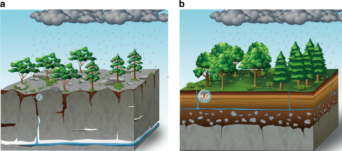
turn, might play the primary role in plant growth. Carbonate rocks mainly consist of highly soluble components, such as limestone, dolomite and gypsum. These components are easily dissolved
by rainwater, which leads to the formation of crevices within the bedrock surface (Fig. 1). The number of crevices is proportional to the bedrock solubility18, and crevices will create
preferential flow paths that may contribute to enhanced regolith water loss by leakage, limits the retention of water in regolith, therefore, lead to high regolith water loss rate (RWLR)18.
Moreover, since carbonate rocks have low contents of acid-insoluble components, only a small quantity of residue is left after dissolution12, further limiting the retention of water. The
variation in the RWLR across the lithosequence will most likely result in remarkable differences in vegetation productivity. Areas dominated by soluble rock substrates are often
characterized by large temporal variations in plant water availability that are induced by rainfall intermittency and droughts during periods without precipitation19. These droughts will
have an important influence on the vegetation growth potential20. In contrast, for bedrock that highly resistant to solution, the accumulation of water improves because these bedrock types
create an impenetrable barrier of residuals and in turn constrain water loss. In this type of environment, reduced water stress for plants over extended periods of drought may lead to
increased overall productivity21. Here, we explore the factors controlling the vegetation productivity on carbonate rock through a case study in China to unravel the role of bedrock
geochemistry, which remained unclear until present. A novel and key aspect of our approach is the consideration of the RWLR in order to evaluate the impact of the temporal variability in
regolith moisture levels during dry spell events at the regional scale. This estimation allowed us to compare the relative strength of bedrock geochemistry versus other competing models
(Table 1), and examine the bedrock geochemistry-RWLR-vegetation productivity relationships. RESULTS REGIONAL VARIATIONS OF PREDICTOR VARIABLES We selected 23 critical zone units (CZUs) are
located along large climatic gradients (Fig. 2). From the south to the north of our study area, the mean annual temperature (MAT) decreases from 19.9 to 11.2 °C, whereas the annual
precipitation (AP) increases from 739 to 2300 mm. CZUs also exhibited high variation in bedrock geocheimsity, with bedrock Si oxide concentrations (BRSi) of 2.4%−49.3%, and bedrock Ca oxide
concentrations (BRCa) of 4.8%−74.2%. In this study, the RWLR was evaluated by variations in regolith moisture during dry spells, while the regolith moisture was represented by the
temperature vegetation drought index (TVDI, see Estimation of RWLR in Methods for more details). During 2001–2010, 428 dry spell events were identified, with an average of 19 dry spell
events in each CZU. Sixty-five percent of these dry spell events were <10 days in duration (Supplementary Fig. 1a) and occurred mainly during fall and winter (i.e., September–December)
(Supplementary Fig. 1b). The values of the RWLR index and the bedrock Si and Ca concentrations (BRCa and BRSi) showed significant differences between carbonate and non-carbonate areas, while
the other selected climatic parameters and contents of chemical elements did not exhibit significant differences between the carbonate and non-carbonate rock types (Supplementary Fig. 2).
RELATIONSHIPS BETWEEN NPP AND PREDICTOR VARIABLES Among the selected soil and climate variables that could affect the net primary productivity (NPP) (Table 2), only the RWLR index and MAT
showed significant relationships with the NPP. The RWLR index exhibited a negative relationship with NPP, whereas MAT was positively correlated with NPP. In particular, the RWLR have greater
explanatory power as a predictor of the variation in NPP than other selected climate and soil variables (Fig. 3 and Table 2). BRSi and BRCa show significant correlations with the RWLR (Fig.
3 and Table 2). BRSi was negatively correlated with the RWLR, whereas BRCa showed a positive relationship with the RWLR. Moreover, the information theoretic approach (ITA, see the Methods
for more detail) confirmed that BRSi emerged as the best predictor of the RWLR. INFLUENCE OF GEOCHEMISTRY ON NPP THROUGH AFFECTING RWLR The structural equation modeling (SEM) was used to
quantify the indirect influence of geochemistry on NPP through affecting RWLR. To simplify the SEM, we did not include the independent variables of AP, Solar duration (SD), the Palmer
Drought Severity Index (PDSI) or soil variables in our model, given that these variables did not show significant relationships with the NPP (Table 2). Each variable included in the SEM
exhibited either a direct or indirect effect on the NPP and contributed to the simplification of the model. Given BRSi and BRCa showed strongly negative correlation (Supplementary Table 1),
to mitigate the problematic effects of collinearity, they were separated into two SEMs (Fig. 4). The separated SEMs performed well, with both explaining 55% of the variations in NPP. The
results of the SEMs were consistent with the output from the ITA analysis, thereby showing that bedrock element contents have greater explanatory power than the MAT as a predictor of NPP.
BRSi and BRCa explained 49% of the variations in NPP, respectively, while MAT explained only 10%. The indirect effect of bedrock geochemistry on the NPP through influences on the RWLR was
identified by the SEMs. BRSi and BRCa were highly correlated with the RWLR, which exhibited significantly negative and positive relationships, respectively. Both SEMs showed that the RWLR
was negatively correlated with NPP. VEGETATION ACTIVITY–TEMPERATURE RELATIONSHIPS IN GLOBAL KARST The mean normalized difference vegetation index (NDVI) from April to September was used as a
measure to assess vegetation activity across the 12 largest karst regions located at mid-latitudes of the Northern Hemisphere. The results showed that vegetation activity exhibited
different sensitivity to interannual temperature variations in these karst regions compared to the surrounding areas, with the exception of the karst zone located in the middle and western
parts of Canada (Fig. 5). Out of the 12 karst regions, 6 showed significantly low correlations between the NDVI and mean temperature for the growing season (_R_NDVI-T), while 4 of them
showed high correlations compared to those surrounding areas, suggesting that carbonate could alter the effect of temperature on vegetation growth. DISCUSSION With a comprehensive,
broad-scale assessment of the influence of bedrock properties on the regional variations in vegetation productivity, we determined that bedrock geochemistry can strongly regulate vegetation
productivity at the regional scale by influencing the regolith water storage capacity. More importantly, even with the marked variations in the climatic and soil conditions across the study
area, the bedrock geochemistry exhibits a major explanatory role for the variations in vegetation productivity, which highlights that the role of bedrock geochemistry is more important than
so far assumed. The strong bedrock geochemistry-RWLR-vegetation productivity associations could be elucidated from several possible mechanisms. The bedrock geochemistry might be linked to
its mineral composition in a way that responsible for solution process, which thus influence the regolith water-holding capacity16,22. Solution-resistant minerals are quite different in the
Ca-rich and Si-rich bedrock, resulting in differentiated water-holding capacity substrate and consequently differentiated vegetation growth potential. Other possible lithological controls on
the regolith water-holding capacity might act by influencing the regolith thickness23,24,25. In the karst regions, high Ca concentrations in bedrock might result in thin regolith, which on
its turn might correspond to increases in calcium carbonate concentrations, resulting in low-regolith formation rates for bedrocks with limited acid-insoluble components, as only a small
amount of insoluble residues are derived from dissolution26. Moreover, regolith loss because of underground leakage will further limited the remaining amount of the regolith in these
environments27. Thus, the positive correlation between RWLR and Ca concentrations may reflect the differences in regolith thickness. In addition, the positive correlation between the
regolith water-holding capacity and bedrock Si concentration could be explained by the clay content. Si-rich bedrock derived regolith is typically characterized by high-clay contents. These
high-clay contents improve the regolith water-holding capacity, as they create a regolith structure with smaller pores, and therefore, water can be held at higher suction pressures23; or
because clays create a less penetrable layer that restricts the rate of water infiltration24. The models, including BRSi and BRAl, show the third best explanatory power for the RWLR
(Supplementary Table 2b), which may be evidence of such inference. The bedrock-vegetation connection could also be elucidated from nutrients. Many mineral nutrients that are extremely
important for plant growth (e.g., P and Fe) are derived from bedrock, and their availability may be controlled by the chemical and physical processes at the soil-bedrock interface25,28. This
phenomenon is particularly important in karst regions, where, for example, the P availability is strongly controlled by the CaCO3 content in regolith29,30, as CaCO3 can reduce the P
solubility by producing Ca phosphates31. Hence, as the P limitations are widespread in areas characterized by CaCO3-dominated sedimentary rocks, this is a key factor limiting vegetation
development. However, a lack of P availability data along the lithosequence restricts the current level of knowledge, and therefore future experimental research on designing fertilization
experiments is needed to investigate the functional relationship between P availability and bedrock compositions. By regulating the hydrologic properties of regolith, bedrock composition can
play a fundamental role in vegetation growth. It is reasonable to believe that such lithological regulation is strong enough to change the response of vegetation to climatic factors. More
importantly, the different temperature sensitivities of karst vegetation show that the bottom-up effect of bedrock could presumably have widespread significance in karst regions worldwide.
The different temperature sensitivity of karst vegetation might link to multiple mechanisms. We suspect that the typically low-regolith water-holding capacity of these systems significantly
enlarges the impacts of drought events on the vegetation development, and therefore change association of vegetation productivity to temperature. Moreover, it is noteworthy that the
influence of land use, which can interact with role of bedrock, strongly change the response of vegetation to climate change. While karst is usually characterized by thin soil layer and a
number of sinkholes underground32, irrational land use could cause serious soil erosion, exposing the bedrock to the surface. The resulting rocky landscape could have a different association
of vegetation productivity to temperature. In addition, the bedrock could be involved in amount of ecological processes and its influence is likely common worldwide, about which our
knowledge is still very limited. Since bedrock have the potential to obscure or distort the influence of climate, our ability for predicting vegetation activity under warming climate will
benefit from empirical research of lithological control. For example, in Guizhou Province, it is reasonable to expect that increasing temperature would have stronger influence on karst
vegetation, since they suffer more drought stress than non-karst regions. However, the influence of bedrock has not been widely addressed, therefore, we hope the evidence presented here will
provide motivation for other ecologists to explore the bedrock-vegetation link in other karst systems. Although our study highlights the impact of bedrock geochemistry on vegetation
productivity, we do not intend to deny the importance of climate. The dissolution and weathering of bedrock is not only determined by its mineral compositions, but also depend on climate. We
have to admit that, due to the limitation of direct measurement of regolith thickness and water-holding capacity as well as observation of ecological processes at regional scale, the
bedrock geochemistry-regolith water-holding capacity-vegetation productivity connections can only be elucidated from statistical analysis rather than direct observation in this study.
Moreover, as we focus on a regional level impact of bedrock geochemistry, we have not discussed the great heterogeneities in belowground future, climate feature, and vegetation composition
within the karst critical zone in our study region. More explicitly assess the role of bedrock will benefit from long term critical zone monitoring and experimental research worldwide. In
conclusion, our study emphasizes that bedrock geochemistry has a great potential to influence plant growth in kart areas through controlling the regolith water-holding capacity. Hence, these
results indicate that the role of bedrock geochemistry in vegetation productivity could have been underestimated. Despite the uncertainties, the critical zone approach employed in this
study provide evidence about importance of bedrock on vegetation, as the functioning of terrestrial ecosystems is determined by a wide range of processes with complex interactions across the
atmosphere, biosphere, pedosphere and lithosphere, all these components need to be considered to obtain a full and detailed picture of any studied terrestrial ecosystem. Therefore, an
understanding of vegetation productivity and associated drivers can be obtained from coordinated multidisciplinary scientific research approaches, which are based on the critical zone
framework as presented in this paper. METHODS REGIONAL SETTINGS The study area covers the entire Guizhou Province (N24°30′–29°13′, E103°1′–109°30′; Fig. 2). This area is 128,480 km2 and is
characterized by numerous karst geological formations, accounting for 64% of Guizhou Province’s lithology, which contains a variety of different carbonated rock types. The remaining 36% of
the lithology (mainly present in the southern, northern and southeastern parts of Guizhou) consists of igneous and metamorphic rocks, which are typically rich in silicon (Si) and have low
calcium carbonate contents. The study region is characterized by a subtropical humid monsoonal climate with a MAT of ca. 11 − 20 °C and mean AP of ca. 730 − 2300 mm. The precipitation is
seasonally variable, with ~75% of the AP occurring during the summer and autumn (June–November). DATA COMPILATION To study the vegetation-regolith-bedrock links, 23 CZUs were established
(Fig. 2 and Supplementary Fig. 3) with a radius of 20 km and a meteorological observation station at the center of each zone. The selection of sites was based on the quality of precipitation
data. To estimate the regolith water-holding capacity of each site, it was necessary to investigate the precipitation patterns and estimate the variation in soil moisture during dry spells,
so each CZU should have a meteorological observation station at the center. There are 71 meteorological observation stations in Guizhou Province, but only 30 of them have precipitation data
covering a time span of 10 years (i.e., 2001–2010). We also excluded the sites on which the associated meteorological observation was relocated during 2001–2010, as well as sites
characterized by <10 identifiable dry spells, resulting in a final selection of 23 sites in total, which satisfy our study design: the selected sites were distributed evenly throughout
Guizhou Province, including different bedrock types and along a wide climate range; the sample size was appropriate in order to carry out all the presented statistical analyses because we
treated each site as a sample, which makes our statistical approaches robust, and hence, our results are reliable. This particular CZU area extent was chosen based on the recommendation of
Liu et al.33, as the meteorological station data are representative of the entire zone, because homogeneous climatic conditions within each CZU can be assumed. The 23 CZUs are well
distributed across the entire study area (i.e., Guizhou Province, Fig. 2). Fourteen of these CZUs are located on carbonate rock, whereas nine are on clastic rock. The remote sensing
retrieved terrestrial annual NPP values were obtained from Resource and Environment Data Cloud Platform with a spatial resolution of 1 × 1 km (http://www.resdc.cn/Default.aspx), which was
estimated from the light energy utilization model (GLM_PEM)34. This dataset was used to obtain an approximate estimate of the regional vegetation growth for each CZU. The time span for both
the climatic and NPP data was from 2001 to 2010. PREDICTOR VARIABLES FOR NPP We used a total of seven predictor variables (Table 1) in order to explain the vegetation productivity. These
variables were selected since they are related to the hypotheses of this study and widely considered potential drivers of vegetation productivity in Guizhou35,36,37. More details about these
variables were provided below. We used meteorological station data (available at http://data.cma.cn/), which included daily temperature, precipitation and solar radiation covering the
period 2001–2010. The associated climate variables (MAT, SD, AP, PDSI) were calculated for each CZU. In each CZU, three sites were selected for bedrock and soil sampling within each
lithologic unit (Supplementary Fig. 3), and the delineation of the geological system was based on the 1:50,000 scale geologic map from the National Geological Archives of China,
http://www.ngac.org.cn). In total, 204 sampling sites were established. To avoid artificial disturbance effects, the selected sites were kept as far away from farms, towns and cities as
possible. All soil and bedrock samples were taken from fresh road cuts. To reduce the influence of fire events and grazing activity during evaluation of importance of bedrock geochemistry to
vegetation productivity, the selected road cuts were covered by intact and undamaged vegetation. At each site, three profiles were sampled, each of which were separated by 5 − 50 m,
depending on the length of the road cut. A ring-knife was used to collect soils from 0 − 30 cm depth and fresh bedrock samples were collected using a geological hammer. In total, 612 bedrock
and 607 soil samples were collected (five soil samples were not obtained due to a lack of significant soil coverage). In the laboratory, composite samples were made by thoroughly mixing the
replicate soil samples (from the same stratigraphic unit and CZU) before being oven dried (40 °C, 72 h) and sieved (2 mm mesh size to remove plant material and stones). Subsequently, each
sample was crushed and milled to 100 μm to allow for soil chemical measurements. The total soil nitrogen (soil N) was measured by a standard Elemental Analyzer (Vario EL, Germany). All
bedrock samples were crushed and powdered to 50 μm using a three head grinding machine (XPM-φ120 × 3, China). Replicate bedrock samples (same stratigraphic unit and CZU) were mixed and then
fired (550 °C, 12 h). Concentrations of major bedrock elements were measured by X-ray fluorescence spectrometry (M4 TORNADO, Germany). Soil N contents and the major bedrock elemental
concentrations were weighted by area fractions of the different stratigraphic units present within each CZU. ESTIMATION OF RWLR In the karst regions, the hydrological function of substrate
is characterized by high-spatial heterogeneity38. More precisely the regolith water-holding capacity is not only influenced by regolith thickness and topography, but also depends on the
network of fractures and fissures (Fig. 1). Thus, even in the CZU dominated by geochemically homogeneous bedrock, the variations in the RWLR can be great within a CZU. Hence, the
relationship between bedrock geochemistry and RWLR is difficult to detect through direct measurements over a small spatial scale (e.g., considering detailed on-site monitoring).
Nevertheless, large scale surveys of regolith water dynamics can help to determine whether bedrock geochemistry is an important regulator of the RWLR. In this study, we assessed the RWLR
across the different CZUs using a satellite-based index. We quantified the variations in soil moisture during dry spells, assumed that a high RWLR corresponded to high variations in soil
moisture. The TVDI that has been widely used for soil moisture monitoring is used as a surrogate variable of soil moisture39,40. More importantly, previous studies showed that TVDI was
highly correlated with soil moisture in karst regions located in southeast China41,42. In this study, variations in the TVDI during dry spells were used to represent the RWLR (Supplementary
Fig. 4). TVDI is based on an empirical parameterization of the relationship between land surface temperature and vegetation indices43. As TVDI is relatively insensitive to precipitation, it
is appropriate to adopt this index to estimate the soil moisture variations related to the RWLR. More precisely, TVDI was calculated as: $${\mathrm{TVDI}} = \frac{{T_{{\mathrm{obs}}} -
T_{\mathrm{w}}}}{{T_{\mathrm{d}} - T_{\mathrm{w}}}}$$ $$T_{\mathrm{d}} = a + b \ast {\mathrm{NDVI}}$$ $$T_{\mathrm{w}} = c + d \ast {\mathrm{NDVI}}$$ where _T_obs is the surface temperature
at each pixel; _T_w represents the minimum surface temperature under the given vegetation conditions, while _T_d represents the maximum surface temperature, which is estimated from the edge
of the NDVI/_T_obs space (3). Therefore, _T_w and _T_d are linear functions of NDVI, the _a_, _b_, _c_, and _d_ associated parameters were estimated at the pixel level, and hence, high TVDI
values indicate high-surface water deficits. Furthermore, as the monitoring of soil moisture changes during dry spells requires fine temporal resolution data, the satellite images used to
calculate the TVDI were obtained from the MODIS–Terra sensor (i.e., Ts: MODLT1F, 5-day scaled at 1 km resolution; NDVI: MODND1F, with 5-day interval at 500 m resolution.
http://www.gscloud.cn/), covering a time period from 2001 to 2010. The Ts and NDVI products includes atmospheric corrections to eliminate the influence of background noise. To match the
pixel size of the NDVI map with the Ts map, the 500-m resolution of NDVI images were resampled to 1 km, using the nearest-neighbor-interpolation technique. The TVDI images of Guizhou
Province of China were analyzed using ENVI 5.1 software, and then each CZU was extracted using ArcGIS. If the qualities of the NDVI or Ts images were unacceptable for the TVDI estimation,
they were excluded. For each CZU, the RWLR was calculated as the average variation in TDVI during dry spells (Supplementary Fig. 4). In this study, a dry spell was defined as the period of 5
or more consecutive days with no precipitation: $${\mathrm{RWLR}} = \mathop {\sum}\limits_{i = n} {\overline {\frac{{{\mathrm{TVDI}}_{b,i} - {\mathrm{TVDI}}_{a,i}}}{{\Delta T_{ab,i}}}} }
\times 100$$ _n_ represents the number of observable dry spells from 2001 to 2010; _i_ represents the ith dry spell, _a_ and _b_ represent the _a_th and _b_th TVDI (_b_ > _a_), ∆T_ab_
represents the time interval between _a_ and _b_. STATISTICAL ANALYSIS To compare the importance of the RWLR in predicting the NPP with other variables, and to evaluate the predictive power
of the bedrock concentrations of the major elements for the RWLR, the ITA44 was performed. This approach allowed us to determine the relative variable importance (RVI) of each explanatory
variable. All possible combinations of explanatory variables were tested. The best model subset for NPP and RWLR was identified by summing the Akaike weights of the highest ranked models
until the value exceeded 0.95. The RVI for each of the candidate variables was calculated by summing the Akaike weights for all models in which the variable occurred in the best model
subset. To avoid collinearity among variables, we pre-selected the candidate variable based on our hypothesis and the performance of the prediction, which was estimated using a linear model
(LM). Wherever two variables exhibited strongly collinearity (Pearson’s | _r_ | > 0.70)45, we excluded the variable showing weaker (greater Akaike information criterion (AIC)) with the
response variables. One exception was BRSi and BRCa, which were strongly correlated (Supplementary Table 1) but we did not exclude either because both showed a significant relationship with
RWLR and the AIC values were very close; and they even showed a high collinearity, but they might influence the RWLR via different mechanisms. Therefore, we separated the RWLR models into
two subsets, with BRSi excluded in one model subset, and BRCa excluded in the other subset. The LMs were conducted using R3.1.0 software46, and the model selection was performed using the
“dredge” function in R package MuMIN47. STRUCTURAL EQUATION MODEL OF VEGETATION PRODUCTIVITY To explore the interactions between bedrock geochemistry, RWLR, and NPP, and assess the indirect
influence of bedrock geochemistry on NPP, a SEM48 was developed to understand the relationships among bedrock geochemistry, the RWLR, climatic factors, soil nutrients and NPP. The use of a
SEM allows for the direct and indirect effects of candidate variables to be considered. Furthermore, SEM can be used to test whether the integral model is statistically acceptable. In our
SEM, the RWLR and vegetation productivity were treated as response variables, whereas the bedrock geochemistry, and climatic and soil variables were treated as explanatory variables. First,
we designed an SEM to investigate the relative importance of bedrock geochemistry on vegetation productivity through regulation of the RWLR. Additionally, we assessed the influences of
climate and soil variables on the NPP, as well as the relationships with the RWLR. Since this study is characterized by a rather small sample size (23 CZUs), a model simplification is
required. We considered only those explanatory variables showing significant relationships with the response variables in our SEM analysis. An additional component for the SEM was developed
to evaluate the residual correlations and modification indices after model’s execution. The root mean square error of approximation (RMSEA) and the comparative fit index (CFI) were used to
evaluate the goodness of fit. The final SEM was chosen when the following criteria were met: _p_-values of _χ_2 and the goodness of fit test _p_ > 0.05; CFI > 0.9, and lower 90%
confidence intervals (CIs) for RMSEA < 0.05 (ref. 18). The SEMs were calculated using the R packages “sem”49 and “lavaan”50. CALCULATION OF THE NDVI-TEMPERATURE RELATIONSHIP To estimate
the influence of bedrock on changes to the response of vegetation activity to temperature variability, 12 largest karst regionss from mid-latitude bands (30°–60°) of the Northern Hemisphere
were selected to detect their temperature variation signals of vegetation productivity. We chose this area because: first, the mid-latitudes in the Northern Hemisphere exhibits obvious
climate seasonal variation, and climate change will most probably have a significant influence on the vegetation productivity51,52. Second, A total of 61% of the world’s karst regionss are
distributed in this zone53. Moreover, the carbonate rock areas located in deserts were discarded from further analysis, as the NDVI-values highlighted the lack of any significant vegetation
development in these areas. The temperature variation signal of vegetation productivity is calculated as the correlation coefficient between NDVI (obtained from Global Inventory Modeling and
Mapping Studies, spatial resolution: 0.5°; biweekly data from 1982 to 2011)54 and growing season mean temperature (April–September, obtained from Climate Research Unit55, the spatial
resolution and temporal range are consistent with NDVI) (_R_NDVI-GT) at the pixel level. To assess the influence of bedrock on the relationship between vegetation activity and temperature,
we employed a buffer zone approach. We compared the _R_NDVI-GT within carbonate rock areas and buffer zones outside the carbonate rock areas boundaries by Mann–Whitney Wilcoxon test. The
width of these buffer zones is 50 km (1 pixel), because this width minimizes the influence of climate and results in similar numbers of pixels in the inner and outer areas. DATA AVAILABILITY
The authors declare that the source data supporting the findings of this study are provided within the paper. REFERENCES * Myneni, R. B. & Hall, F. G. The interpretation of spectral
vegetation indexes. _IEEE Geosci. Remote_ 33, 481–486 (1995). Article ADS Google Scholar * Nemani, R. R. et al. Climate-driven increases in global terrestrial net primary production from
1982 to 1999. _Science_ 300, 1560–1563 (2003). Article ADS CAS PubMed Google Scholar * Anderson, R. G. & O’Halloran, T. L. Biophysical considerations in forestry for climate
protection. _Front. Ecol. Envion._ 9, 174–182 (2011). Article Google Scholar * Cadaret, E. M., Mcgwire, K. C., Nouwakpo, S. K., Weltz, M. A. & Saito, L. Vegetation canopy cover effects
on sediment erosion processes in the Upper Colorado River Basin Mancos Shale formation, Price, Utah, USA. _Catena_ 147, 334–344 (2016). Article Google Scholar * Zeng, Y. J. et al.
Ecohydrological effects of stream-aquifer water interaction: a case study of the Heihe River basin, northwestern China. _Hydrol. Earth Syst. Sci._ 20, 2333–2352 (2016). Article ADS Google
Scholar * Richter, D. D. & Billings, S. A. One physical system: Tansley’s ecosystem as Earth’s critical zone. _N. Phytol._ 206, 900–912 (2015). Article CAS Google Scholar * Hahm, W.
J., Riebe, C. S., Lukens, C. E. & Araki, S. Bedrock composition regulates mountain ecosystems and landscape evolution. _Proc. Natl Acad. Sci. USA_ 111, 3338–3343 (2014). Article ADS
CAS PubMed PubMed Central Google Scholar * Morford, S. L., Houlton, B. Z. & Dahlgren, R. A. Increased forest ecosystem carbon and nitrogen storage from nitrogen rich bedrock.
_Nature_ 477, 78–81 (2011). Article ADS CAS PubMed Google Scholar * Rempe, D. M. & Dietrich, W. E. Direct observations of rock moisture, a hidden component of the hydrologic cycle.
_Proc. Natl Acad. Sci. USA_ 115, 2664–2669 (2018). Article ADS CAS PubMed PubMed Central Google Scholar * Zhang, L., Guo, S. & Wu, B. The source, spatial distribution and risk
assessment of heavy metals in soil from the Pearl River Delta based on the national multi-purpose regional geochemical survey. _PLoS ONE._ 10, e0132040 (2015). Article PubMed PubMed
Central CAS Google Scholar * Silver, W. L. et al. Effects of soil texture on belowground carbon and nutrient storage in a lowland Amazonian forest ecosystem. _Ecosystems_ 3, 193–209
(2000). Article CAS Google Scholar * Milodowski, D. T., Mudd, S. M. & Mitchard, E. T. A. Erosion rates as a potential bottom-up control of forest structural characteristics in the
Sierra Nevada Mountains. _Ecology_ 96, 31–38 (2015). Article PubMed Google Scholar * Wolf, J., Brocard, G., Willenbring, J., Porder, S. & Uriarte, M. Abrupt change in forest height
along a tropical elevation gradient detected using airborne LiDAR. _Remote Sens._ 8, 864 (2016). Article ADS Google Scholar * Praeg, N., Wagner, A. O. & Illmer, P. Plant species,
temperature, and bedrock affect net methane flux out of grassland and forest soils. _Plant Soil._ 410, 193–206 (2017). Article CAS Google Scholar * Kruckeberg, A. R. _Geology and Plant
Life: The Effects of Landforms and Rock Types on Plants_ 169–193 (Univ. Washington Press, 2004). * Stephenson, N. L. Climatic control of vegetation distribution: the role of the water
balance. _Am. Nat._ 135, 649–670 (1990). Article Google Scholar * Graham, R., Ann, M. & Kenneth, R. Rock to regolith conversion: producing hospitable substrates for terrestrial
ecosystems. _GSA Today_ 20, 4–9 (2010). Article Google Scholar * Auler, A. S. & Smart, P. L. The influence of bedrock‐derived acidity in the development of surface and underground
karst: evidence from the Precambrian carbonates of semi‐arid northeastern Brazil. _Earth Surf. Proc. Landf._ 28, 157–168 (2003). Article ADS CAS Google Scholar * Long, D. et al. Drought
and flood monitoring for a large karst plateau in Southwest China using extended GRACE data. _Remote Sens. Environ._ 155, 145–160 (2014). Article ADS Google Scholar * Schwinning, S. The
water relations of two evergreen tree species in a karst savanna. _Oecologia_ 158, 373–383 (2008). Article ADS PubMed Google Scholar * Ivits, E., Horion, S., Fensholt, R. & Cherlet,
M. Drought footprint on European ecosystems between 1999 and 2010 assessed by remotely sensed vegetation phenology and productivity. _Glob. Change Biol._ 20, 581–593 (2014). Article ADS
Google Scholar * Buss, H. L. et al. Lithological influences on contemporary and long-term regolith weathering at the Luquillo Critical Zone Observatory. _Geochem. Cosmochem. Acta_ 196,
224–251 (2017). Article ADS CAS Google Scholar * Abuel-Naga, H. & Bouazza, A. A novel laboratory technique to determine the water retention curve of geosynthetic clay liners.
_Geosynth. Int._ 17, 313–322 (2010). Article Google Scholar * Wang, S. J. et al. How types of carbonate rock assemblages constrain the distribution of karst rocky desertified land in
Guizhou Province, PR China: phenomena and mechanisms. _Land Degrad. Dev._ 15, 123–131 (2004). Article Google Scholar * Dai, Q. et al. Surface erosion and underground leakage of yellow soil
on slopes in karst regions of southwest China. _Land Degrad. Dev._ 29, 2438–2448 (2018). Article Google Scholar * Estes, C. J. Storm water infiltration in claysoils: a case study of storm
water retention and infiltration techniques in the North Carolina Piedmont. In _Proc. 2nd Natl Low Impact Dev. Conf_. 159–170 (American Society of Civil Engineers, 2009). * Eimil-Fraga, C.,
Rodríguez-Soalleiro, R., Sánchez-Rodríguez, F., Pérez-Cruzado, C. & Álvarez-Rodríguez, E. Significance of bedrock as a site factor determining nutritional status and growth of maritime
pine. _Forest. Ecol. Manag._ 331, 19–24 (2014). * Holloway, J. M., Dahlgren, R. A., Hansen, B. & Casey, W. H. Contribution of bedrock nitrogen to high nitrate concentrations in stream
water. _Nature_ 395, 785–788 (1998). Article ADS CAS Google Scholar * Lajtha, K. & Bloomer, S. H. Factors affecting phosphate sorption and phosphate retention in a desert ecosystem.
_Soil Sci._ 146, 160–167 (1988). Article ADS CAS Google Scholar * Lajtha, K. & Schlesinger, W. H. The biogeochemistry of phosphorus cycling and phosphorus availability along a desert
soil chronosequence. _Ecology_ 69, 24–39 (1988). Article CAS Google Scholar * Holford, I. C. R. Soil phosphorus: its measurement, and its uptake by plants. _Soil Res._ 35, 227–239
(1997). Article CAS Google Scholar * Wang, S. J. et al. Karst rocky desertification in southwestern China: geomorphology, landuse, impact and rehabilitation. _Land Degrad. Dev._ 15,
115–121 (2004). Article Google Scholar * Liu, Y. et al. Quality control and representativeness of automatic weather station rain gauge data. _Chin. J. Atmos. Sci._ 38, 159–170 (2014).
Google Scholar * Goetz, S. J. et al. Satellite remote sensing of primary production: an improved production efficiency modeling approach. _Ecol. Model._ 122, 239–255 (1999). Article Google
Scholar * Wang, B. et al. Effect of climate variables on the modeling of vegetation net primary productivity in karst regions. In _Proc. 19th Int. Congress Model. Simul._ (eds. Chan. F. et
al.) 2634–2640 (MODSIM, 2011). * Zhou, Y. et al. Comparative analysis on responses of vegetation productivity relative to different drought monitor patterns in Karst regions of southwestern
China. _Appl. Ecol. Env. Res._ 17, 85–105 (2019). Article Google Scholar * Zhang, P. et al. Soil quality changes in land degradation as indicated by soil chemical, biochemical and
microbiological properties in a karst regions of southwest Guizhou, China. _Environ. Geol._ 51, 609–619 (2006). Article ADS CAS Google Scholar * Yang, J., Nie, Y., Chen, H., Wang, S.
& Wang, K. Hydraulic properties of karst fractures filled with soils and regolith materials: implication for their ecohydrological functions. _Geoderma_ 276, 93–101 (2016). Article ADS
Google Scholar * Cao, X., Feng, Y. & Wang, J. An improvement of the Ts-NDVI space drought monitoring method and its applications in the Mongolian plateau with MODIS, 2000-2012. _Arab.
J. Geosci._ 9, 433 (2016). Article ADS Google Scholar * Dhorde, A. G. & Patel, N. R. Spatio-temporal variation in terminal drought over western India using dryness index derived from
long-term MODIS data. _Ecol. Inform._ 32, 28–38 (2016). Article Google Scholar * Li, B. L., Ti, C. P., Zhao, Y. Q. & Yan, X. Y. Estimating soil moisture with Landsat data and its
application in extracting the spatial distribution of winter flooded paddies. _Remote Sens._ 8, 38 (2016). Article ADS Google Scholar * Yan, H. B., Zhou, G. Q. & Lu, X. J. Comparative
analysis of surface soil moisture retrieval using VSWI and TVDI in Karst regions. _Proc. SPIE_ 9808, 980806 (2015). Article Google Scholar * Kang, W. M., Luo, Y. X., Zhang, X. B. &
Chen, J. The characteristic of Temperature-Vegetation Drought Index(TVDI) and its application in remote sensing drought monitoring in Guizhou. _Guizhou Agr. Sci._ 36, 27–30 (2008). Google
Scholar * Sandholt, I. et al. A simple interpretation of the surface temperature/vegetation index space for assessment of surface moisture status. _Remote Sens. Environ._ 79, 213–224
(2002). Article ADS Google Scholar * Burnham, K. P. & Anderson, D. R. _Model Selection and Multimodel Inference: A Practical Information-theoretic Approach_ (Springer, 2002). MATH
Google Scholar * Dormann, C. F. et al. Collinearity: a review of methods to deal with it and a simulation study evaluating their performance. _Ecography_ 36, 27–46 (2013). Article Google
Scholar * R Core Team. R: a language and environment for statistical computing. _R Foundation for Statistical Computing_ https://www.R-project.org/ (2014). * Kamil, B. MuMIn: multi-model
inference. R package version 1.43.6. https://CRAN.R-project.org/package=MuMIn (2019). * Grace, J. B. _Structural Equation Modeling and Natural Systems_ (Cambridge Univ. Press, 2006). Book
Google Scholar * John, F., Nie, Z. & Jarrett, B. sem: structural equation models. R package version 3.1-9. https://CRAN.R-project.org/package=sem (2017). * Rosseel, Y. An R package for
structural equation modeling. _J. Stat. Softw._ 48, 1–36 (2012). Article Google Scholar * Piao, S. et al. Evidence for a weakening relationship between interannual temperature variability
and northern vegetation activity. _Nat. Commun._ 5, 5018 (2014). Article ADS CAS PubMed Google Scholar * Lawrence, D. M. & Slingo, J. M. An annual cycle of vegetation in a GCM. Part
I: implementation and impact on evaporation. _Clim. Dynam._ 22, 87–105 (2004). Article ADS Google Scholar * Hollingsworth, E., Brahanna, V., Inlander, E. & Slay, M. Karst regions of
the world (KROW): global karst datasets and maps to advance the protection of karst species and habitats worldwide. In _US Geol. Surv. Karst Interest Group Proc._ (Univ. Arkansas, 2008). *
Xu, L. et al. Temperature and vegetation seasonality diminishment over northern lands. _Nat. Clim. Change_ 3, 581–586 (2013). Article ADS Google Scholar Download references
ACKNOWLEDGEMENTS We thanks Naiqing Fan, Yaomin Qin, Xu Liu, and Xiguang Yang for their help in remote sensing data treatments, and Jie Liu, Canfei Hu and Ridi Li for their support in
collecting bedrock geochemistry data. This study was jointly financed by the Sino-UK Critical Zone Programs of National Natural Science Foundation of China (grant no. 41571130044), and the
National Environmental Research Council of the UK and the Newton Foundation (grant no. NE/N007603/1 and NE/N007530/1). AUTHOR INFORMATION Author notes * Jeroen Meersmans Present address:
TERRA Teaching and Research Centre, Gembloux Agro-Bio Tech, University of Liège, 5030, Gembloux, Belgium AUTHORS AND AFFILIATIONS * College of Urban and Environmental Sciences and MOE
Laboratory for Earth Surface Processes, Peking University, 100871, Beijing, China Zihan Jiang, Hongyan Liu, Hongya Wang & Jian Peng * Cranfield Soil and Agrifood Institute, School of
Water, Energy and Environment, Cranfield University, Cranfield, MK43 0AL, UK Jeroen Meersmans * Geography, College of Life and Environmental Sciences, University of Exeter, Exeter, EX4 4SB,
UK Sophie M. Green & Timothy A. Quine * Faculty of Geographical Science, Beijing Normal University, 100875, Beijing, China Xiuchen Wu * Institute of Surface-Earth System Science, Tianjin
University, 300072, Tianjin, China Zhaoliang Song Authors * Zihan Jiang View author publications You can also search for this author inPubMed Google Scholar * Hongyan Liu View author
publications You can also search for this author inPubMed Google Scholar * Hongya Wang View author publications You can also search for this author inPubMed Google Scholar * Jian Peng View
author publications You can also search for this author inPubMed Google Scholar * Jeroen Meersmans View author publications You can also search for this author inPubMed Google Scholar *
Sophie M. Green View author publications You can also search for this author inPubMed Google Scholar * Timothy A. Quine View author publications You can also search for this author inPubMed
Google Scholar * Xiuchen Wu View author publications You can also search for this author inPubMed Google Scholar * Zhaoliang Song View author publications You can also search for this author
inPubMed Google Scholar CONTRIBUTIONS Z.J., J.M., and S.G collected and analyzed the data. H.L. designed the project and this study; Z.J. wrote the manuscript; H.L., H.W., J.P., J.M., S.G.,
T.Q., X.W., Z.S. revised the manuscript. All the authors discussed the results and commented on the manuscript. CORRESPONDING AUTHOR Correspondence to Hongyan Liu. ETHICS DECLARATIONS
COMPETING INTERESTS The authors declare no competing interests. ADDITIONAL INFORMATION PEER REVIEW INFORMATION _Nature Communications_ thanks Juan Camilo Villegas and other, anonymous,
reviewers for their contributions to the peer review of this work. Peer review reports are available. PUBLISHER’S NOTE Springer Nature remains neutral with regard to jurisdictional claims in
published maps and institutional affiliations. SUPPLEMENTARY INFORMATION SUPPLEMENTARY TABLES AND FIGURES PEER REVIEW FILE RIGHTS AND PERMISSIONS OPEN ACCESS This article is licensed under
a Creative Commons Attribution 4.0 International License, which permits use, sharing, adaptation, distribution and reproduction in any medium or format, as long as you give appropriate
credit to the original author(s) and the source, provide a link to the Creative Commons license, and indicate if changes were made. The images or other third party material in this article
are included in the article’s Creative Commons license, unless indicated otherwise in a credit line to the material. If material is not included in the article’s Creative Commons license and
your intended use is not permitted by statutory regulation or exceeds the permitted use, you will need to obtain permission directly from the copyright holder. To view a copy of this
license, visit http://creativecommons.org/licenses/by/4.0/. Reprints and permissions ABOUT THIS ARTICLE CITE THIS ARTICLE Jiang, Z., Liu, H., Wang, H. _et al._ Bedrock geochemistry
influences vegetation growth by regulating the regolith water holding capacity. _Nat Commun_ 11, 2392 (2020). https://doi.org/10.1038/s41467-020-16156-1 Download citation * Received: 02 May
2019 * Accepted: 17 April 2020 * Published: 13 May 2020 * DOI: https://doi.org/10.1038/s41467-020-16156-1 SHARE THIS ARTICLE Anyone you share the following link with will be able to read
this content: Get shareable link Sorry, a shareable link is not currently available for this article. Copy to clipboard Provided by the Springer Nature SharedIt content-sharing initiative