- Select a language for the TTS:
- UK English Female
- UK English Male
- US English Female
- US English Male
- Australian Female
- Australian Male
- Language selected: (auto detect) - EN
Play all audios:
ABSTRACT Surface meltwater drains across ice sheets, forming melt ponds that can trigger ice-shelf collapse1,2, acceleration of grounded ice flow and increased sea-level rise3,4,5. Numerical
models of the Antarctic Ice Sheet that incorporate meltwater’s impact on ice shelves, but ignore the movement of water across the ice surface, predict a metre of global sea-level rise this
century5 in response to atmospheric warming6. To understand the impact of water moving across the ice surface a broad quantification of surface meltwater and its drainage is needed. Yet,
despite extensive research in Greenland7,8,9,10 and observations of individual drainage systems in Antarctica10,11,12,13,14,15,16,17, we have little understanding of Antarctic-wide surface
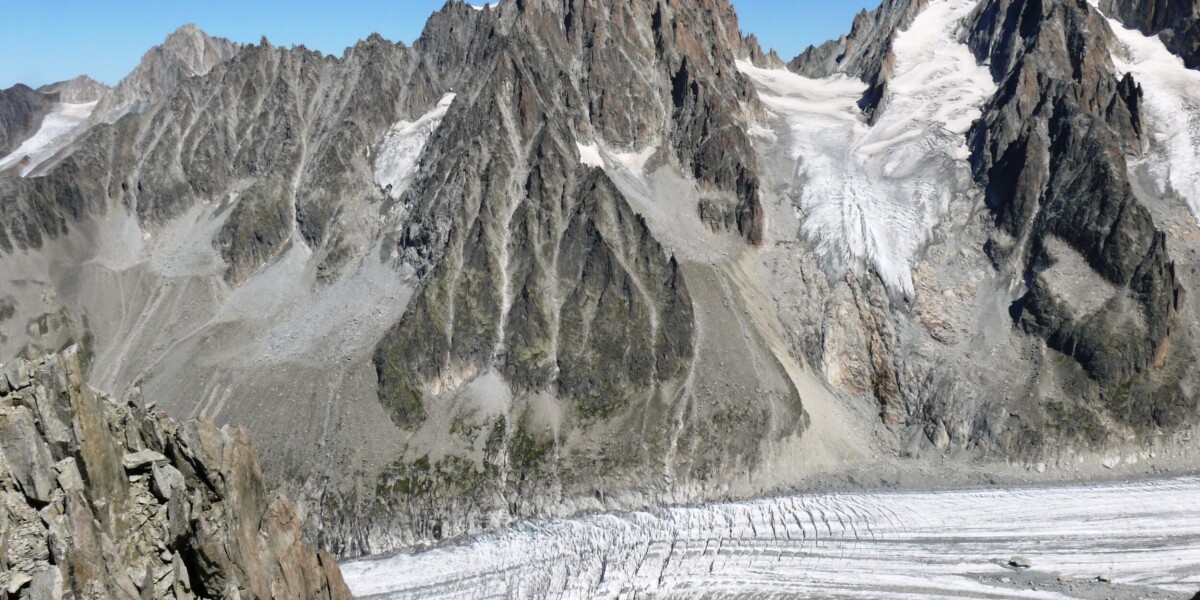
hydrology or how it will evolve. Here we show widespread drainage of meltwater across the surface of the ice sheet through surface streams and ponds (hereafter ‘surface drainage’) as far
south as 85° S and as high as 1,300 metres above sea level. Our findings are based on satellite imagery from 1973 onwards and aerial photography from 1947 onwards. Surface drainage has
persisted for decades, transporting water up to 120 kilometres from grounded ice onto and across ice shelves, feeding vast melt ponds up to 80 kilometres long. Large-scale surface drainage
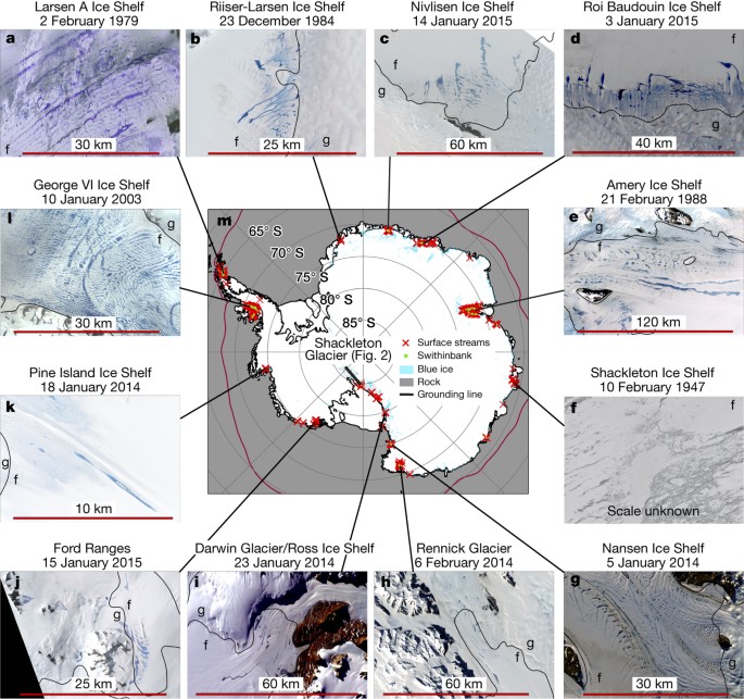
could deliver water to areas of ice shelves vulnerable to collapse, as melt rates increase this century. While Antarctic surface melt ponds are relatively well documented on some ice
shelves, we have discovered that ponds often form part of widespread, large-scale surface drainage systems. In a warming climate, enhanced surface drainage could accelerate future ice-mass
loss from Antarctic, potentially via positive feedbacks between the extent of exposed rock, melting and thinning of the ice sheet. Access through your institution Buy or subscribe This is a
preview of subscription content, access via your institution ACCESS OPTIONS Access through your institution Access Nature and 54 other Nature Portfolio journals Get Nature+, our best-value
online-access subscription $32.99 / 30 days cancel any time Learn more Subscribe to this journal Receive 51 print issues and online access $199.00 per year only $3.90 per issue Learn more
Buy this article * Purchase on SpringerLink * Instant access to full article PDF Buy now Prices may be subject to local taxes which are calculated during checkout ADDITIONAL ACCESS OPTIONS:
* Log in * Learn about institutional subscriptions * Read our FAQs * Contact customer support SIMILAR CONTENT BEING VIEWED BY OTHERS A WEST ANTARCTIC GROUNDING-ZONE ENVIRONMENT SHAPED BY
EPISODIC WATER FLOW Article Open access 12 May 2025 ANTARCTIC BASAL ENVIRONMENT SHAPED BY HIGH-PRESSURE FLOW THROUGH A SUBGLACIAL RIVER SYSTEM Article 27 October 2022 THE PAST, PRESENT, AND
FUTURE EVOLUTION OF AURORA SUBGLACIAL BASIN’S SUBGLACIAL DRAINAGE SYSTEM Article Open access 20 March 2025 CHANGE HISTORY * _ 08 NOVEMBER 2017 Please see accompanying Corrigendum
(http://doi.org/10.1038/nature24478). In this Letter, we misinterpreted the units of the melt rate variable output by the regional climate model RACMO2 to be kilograms per square metre per
day instead of kilograms per square metre per second. This caused us to underestimate modelled melt rates considerably. This error has not been corrected online. _ REFERENCES * Scambos, T.
A., Hulbe, C., Fahnestock, M. & Bohlander, J. The link between climate warming and break-up of ice shelves in the Antarctic Peninsula. _J. Glaciol._ 46, 516–530 (2000) Article ADS
Google Scholar * Rott, H., Skvarca, P. & Nagler, T. Rapid collapse of northern Larsen ice shelf. _Antarct. Sci._ 271, 788–792 (1996) CAS Google Scholar * Rignot, E. et al. Accelerated
ice discharge from the Antarctic Peninsula following the collapse of Larsen B ice shelf. _Geophys. Res. Lett._ 31, L18401 (2004) Article ADS Google Scholar * De Rydt, J., Gudmundsson,
G., Rott, H. & Bamber, J. Modeling the instantaneous response of glaciers after the collapse of the Larsen B Ice Shelf. _Geophys. Res. Lett._ 42, 5355–5363 (2015) Article ADS Google
Scholar * DeConto, R. M. & Pollard, D. Contribution of Antarctica to past and future sea-level rise. _Nature_ 531, 591–597 (2016) Article ADS CAS Google Scholar * Trusel, L. D. et
al. Divergent trajectories of Antarctic surface melt under two twenty-first-century climate scenarios. _Nat. Geosci._ 8, 927–932 (2015) Article ADS CAS Google Scholar * Zwally, J. H. et
al. Surface melt-induced acceleration of Greenland ice-sheet flow. _Science_ 297, 218–222 (2002) Article ADS CAS Google Scholar * Das, S. B. et al. Fracture propagation to the base of
the Greenland ice sheet during supraglacial lake drainage. _Science_ 320, 778–781 (2008) Article ADS CAS Google Scholar * Lüthje, M., Pedersen, L. T., Reeh, N. & Greuell, W.
Modelling the evolution of supraglacial lakes on the West Greenland ice-sheet margin. _J. Glaciol._ 52, 608–618 (2006) Article ADS Google Scholar * Banwell, A. F. et al. Supraglacial
lakes on the Larsen B ice shelf, Antarctica, and at Paakitsoq, West Greenland: a comparative study. _Ann. Glaciol._ 55, 1–8 (2014) Article ADS Google Scholar * Winther, J. G., Elvehøy,
H., Bøggild, C. E., Sand, K. & Liston, G. Melting, runoff and the formation of frozen lakes in a mixed snow and blue-ice field in Dronning Maud Land, Antarctica. _J. Glaciol._ 42,
271–278 (1996) Article ADS CAS Google Scholar * Langley, E. S., Leeson, A. A., Stokes, C. R. & Jamieson, S. S. R. Seasonal evolution of supraglacial lakes on an East Antarctic outlet
glacier. _Geophys. Res. Lett._ 43, 8563–8571 (2016) Article ADS Google Scholar * Phillips, H. A. Surface meltstreams on the Amery Ice Shelf, East Antarctica. _Ann. Glaciol._ 27, 177–181
(1998) Article ADS Google Scholar * Swithinbank, C. W. in _Satellite Image Atlas of Glaciers of the World: Antarctica_ (eds Williams, R. S. & Ferrigno, J. G. ) USGS Prof. Paper 1386-B
(USGS, 1988) * Kingslake, J., Ng, F. & Sole, A. Modelling channelized surface drainage of supraglacial lakes. _J. Glaciol._ 61, 185–199 (2015) Article ADS Google Scholar * Leeson, A.
A. et al. Supraglacial lakes on the Greenland ice sheet advance inland under warming climate. _Nat. Clim. Chang._ 5, 51–55 (2015) Article ADS Google Scholar * Lenaerts, J. T. M. et al.
Meltwater produced by wind-albedo interaction stored in an East Antarctic ice shelf. _Nat. Clim. Chang._ 7, 58–62 (2017) Article ADS Google Scholar * Banwell, A. F., MacAyeal, D. R. &
Sergienko, O. V. Breakup of the Larsen B Ice Shelf triggered by chain reaction drainage of supraglacial lakes. _Geophys. Res. Lett._ 40, 5872–5876 (2013) Article ADS Google Scholar *
Rack, W. & Rott, H. Pattern of retreat and disintegration of the Larsen B ice shelf, Antarctic Peninsula. _Ann. Glaciol._ 39, 505–510 (2004) Article ADS Google Scholar * Bell, R. E .
et al. Antarctic ice shelf potentially stabilized by export of meltwater in surface river. _Nature_http://dx.doi.org/10.1038/nature22048 (this issue, 2017) * Reynolds, J. M. Lakes on George
VI Ice Shelf, Antarctica. _Polar Rec._ 20, 425–432 (1981) Article Google Scholar * Leppäranta, M., Järvinen, O. & Mattila, O.-P. Structure and life cycle of supraglacial lakes in
Dronning Maud Land. _Antarct. Sci._ 25, 457–467 (2013) Article ADS Google Scholar * Liston, G. E., Bruland, O., Elvehøy, H. & Sand, K. Below-surface ice melt on the coastal Antarctic
ice sheet. _J. Glaciol._ 45, 273–285 (1999) Article ADS Google Scholar * Box, J. E. et al. Greenland ice sheet albedo feedback: thermodynamics and atmospheric drivers. _Cryosphere_ 6,
821–839 (2012) Article ADS Google Scholar * Das, I. et al. Influence of persistent wind scour on the surface mass balance of Antarctica. _Nat. Geosci._ 6, 367–371 (2013) Article ADS CAS
Google Scholar * Hui, F. et al. Mapping blue-ice areas in Antarctica using ETM+ and MODIS data. _Ann. Glaciol._ 55, 129–137 (2014) Article ADS Google Scholar * Bintanja, R. &
Reijmer, C. H. Meteorological conditions over Antarctic blue-ice areas and their influence on the local surface mass balance. _J. Glaciol._ 47, 37–50 (2001) Article ADS Google Scholar *
Depoorter, M. A., Bamber, J. L., Griggs, J. A., Lenaerts, J. T. M. & Ligtenberg, S. R. M. Calving fluxes and basal melt rates of Antarctic ice shelves. _Nature_ 502, 89–92 (2013) Article
ADS CAS Google Scholar * Bindschadler, R. et al. The Landsat image mosaic of Antarctica. _Remote Sens. Environ._ 112, 4214–4226 (2008) Article ADS Google Scholar * Fretwell, P. et
al. Bedmap2: improved ice bed, surface and thickness datasets for Antarctica. _Cryosphere_ 7, 375–393 (2013) Article ADS Google Scholar * Rignot, E., Mouginot, J. & Scheuchl, B. Ice
flow of the Antarctic ice sheet. _Science_ 333, 1427–1430 (2011) Article ADS CAS Google Scholar * Van Wessem, J. M. et al. Improved representation of East Antarctic surface mass balance
in a regional atmospheric climate model. _J. Glaciol._ 60, 761–770 (2014) Article ADS Google Scholar * Pope, A. et al. Estimating supraglacial lake depth in West Greenland using Landsat 8
and comparison with other multispectral methods. _Cryosphere_ 10, 15–27 (2016) Article ADS Google Scholar * Sneed, W. A. & Hamilton, G. Evolution of melt pond volume on the surface
of the Greenland Ice Sheet. _Geophys. Res. Lett._ 34, L03501 (2007) Article ADS Google Scholar * Haran, T ., Bohlander, J ., Scambos, T ., Painter, T & Fahnestock, M. _MODIS Mosaic of
Antarctica 2003-2004 (MOA2004) Image Map_ http://dx.doi.org/10.7265/N5ZK5DM5 (National Snow and Ice Data Center, 2005) Download references ACKNOWLEDGEMENTS We acknowledge funding from NASA
grant number NNX14AH79G, NSF grant numbers GG008566 and 1443534, and the Old York Foundation. We also thank I. Cordero for assisting with meltwater feature digitization. We thank J. Lenaerts
for sharing RACMO2 climate model output. AUTHOR INFORMATION AUTHORS AND AFFILIATIONS * Lamont-Doherty Earth Observatory, Columbia University, Palisades, New York, USA Jonathan Kingslake,
Indrani Das & Robin E. Bell * Department of Geography, The University of Sheffield, Sheffield, UK Jeremy C. Ely Authors * Jonathan Kingslake View author publications You can also search
for this author inPubMed Google Scholar * Jeremy C. Ely View author publications You can also search for this author inPubMed Google Scholar * Indrani Das View author publications You can
also search for this author inPubMed Google Scholar * Robin E. Bell View author publications You can also search for this author inPubMed Google Scholar CONTRIBUTIONS J.K. led the project
and the preparation of the manuscript. J.C.E. mapped surface drainage in selected locations. I.D. led analysis of climate model output. R.E.B., along with the other authors, assisted with
preparation of the manuscript. CORRESPONDING AUTHOR Correspondence to Jonathan Kingslake. ETHICS DECLARATIONS COMPETING INTERESTS The authors declare no competing financial interests.
ADDITIONAL INFORMATION REVIEWER INFORMATION _Nature_ thanks A. F. Banwell, G. Flowers and the other anonymous reviewer(s) for their contribution to the peer review of this work.
Publisher's note: Springer Nature remains neutral with regard to jurisdictional claims in published maps and institutional affiliations. EXTENDED DATA FIGURES AND TABLES EXTENDED DATA
FIGURE 1 DRAINAGE ON SHACKLETON GLACIER. A, WorldView 1 image showing a surface stream flowing from Shackleton Glacier, across the grounding line28 (black), onto the Ross Ice Shelf, from 11
February 2010. See also Fig. 2j. B, Shackleton Glacier surface profile extracted from Bedmap2 (ref. 30). C–F, Aerial reconnaissance photography over Shackleton Glacier from 12 January 2010.
Photo credit J. Stone, University of Washington, 2010. C, A large pond, P1, at the head of Swithinbank Moraine, SM. D, Meltwater ponds on SM. E, Further surface ponding on SM. F, A meltwater
channel, S5 running parallel to ice flow. Source data for this figure is available in the HTML version of the paper. EXTENDED DATA FIGURE 2 DRAINAGE ONTO AND ACROSS AMERY ICE SHELF. Landsat
imagery from 2015 (A), 1988 (B) and 1974 (C). The black boxes show the extent of Fig. 3b. Drainage basins computed from Bedmap2 (ref. 30) are shown in red in A. The drainage network that
feeds the large pond in Fig. 3b is shown in green and other major drainage systems are shown in blue. See inset in Fig. 3b for location in East Antarctica. The grounding line28 is in black.
EXTENDED DATA FIGURE 3 DRAINAGE ACROSS PINE ISLAND ICE SHELF. A, MODIS Mosaic of Antarctica (MOA)35 image showing the ice shelf and surroundings, including Pine Island Glacier (PIG). Inset
shows location in West Antarctica. White box shows the extent of the images in the other panels. B–H, Satellite imagery showing the growth of a melt pond during the 2013/14 melt season. The
grounding line28 is in black. EXTENDED DATA FIGURE 4 PERSISTENCE OF NINE SURFACE DRAINAGE SYSTEMS. Squares show the year of observations of surface drainage in each system. This figure
represents a lower bound on the occurrence of drainage in each location. Colours indicate whether the observation is from Landsat imagery, WorldView imagery, Aster imagery or aerial
photography. The vertical line at 1972 marks the launch of the first Landsat satellite. See Extended Data Table 2 for details. EXTENDED DATA FIGURE 5 PRE-SATELLITE ERA AERIAL PHOTOGRAPHY OF
PERSISTENT SURFACE DRAINAGE SYSTEMS. A–C, Oblique aerial photography of melt ponds on Roi Baudouin Ice Shelf, fed by surface streams. Inset shows location in West Antarctica. Look direction
is approximately northwards from the grounding line. The pond that appears on the right in A can also be seen in B and C. D, Aerial photograph of Shackleton Glacier, 9 December 1960, showing
meltwater features P1, P2 and S1, that are visible in more recent satellite imagery and aerial photographs (Fig. 2). EXTENDED DATA FIGURE 6 SURFACE DRAINAGE ACROSS THE RIISER–LARSEN ICE
SHELF. A, White box shows the location of the images shown in the other panels. Background image is from MOA. The inset shows the location in East Antarctica. B–E, Landsat images from 1974,
1984, 1988 and 2014. F, Enlarged view of melt ponds in E. In all panels the grounding line28 is in black. EXTENDED DATA FIGURE 7 DRAINAGE ON ROSS ICE SHELF, DOWNSTREAM OF DARWIN GLACIER. A,
The location of the other panels is shown in white, background image is from MOA. Inset shows location in Antarctica. B–F, Landsat satellite images showing meltwater ponding and drainage
crossing the grounding line28 shown in black, over a 40-year period. EXTENDED DATA FIGURE 8 ICE-FLOW SPEED AND PROXIMITY TO ROCK AND BLUE ICE AT SURFACE STREAMS. Proximity of upper ends of
streams to exposed rock (black) and blue-ice areas (blue) and ice-flow speed at the surface at the upper end of the streams, across the entire continent (solid curves) and further south than
75° S (dashed curves) (_n_ = 696). Source data for this figure is available in the HTML version of the paper. POWERPOINT SLIDES POWERPOINT SLIDE FOR FIG. 1 POWERPOINT SLIDE FOR FIG. 2
POWERPOINT SLIDE FOR FIG. 3 POWERPOINT SLIDE FOR FIG. 4 RIGHTS AND PERMISSIONS Reprints and permissions ABOUT THIS ARTICLE CITE THIS ARTICLE Kingslake, J., Ely, J., Das, I. _et al._
Widespread movement of meltwater onto and across Antarctic ice shelves. _Nature_ 544, 349–352 (2017). https://doi.org/10.1038/nature22049 Download citation * Received: 02 December 2016 *
Accepted: 08 March 2017 * Published: 20 April 2017 * Issue Date: 20 April 2017 * DOI: https://doi.org/10.1038/nature22049 SHARE THIS ARTICLE Anyone you share the following link with will be
able to read this content: Get shareable link Sorry, a shareable link is not currently available for this article. Copy to clipboard Provided by the Springer Nature SharedIt content-sharing
initiative