- Select a language for the TTS:
- UK English Female
- UK English Male
- US English Female
- US English Male
- Australian Female
- Australian Male
- Language selected: (auto detect) - EN
Play all audios:
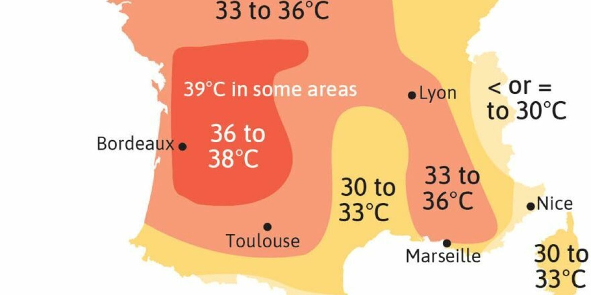
SEE WHERE TEMPERATURES COULD REACH UP TO 39C, AND WHERE THEY COULD BE HIGHEST ON TUESDAY With France facing another heatwave, TEMPERATURES ACROSS THE COUNTRY ARE EXPECTED TO BE SIGNIFICANTLY
WARMER than September averages. Although expected to last the duration of the week, the heatwave will be warmest at the beginning of the week, with temperatures of up to 39C in parts of the
south west. On Tuesday, although such extreme highs are not expected, the warm weather will spread across most of the country, with almost the entirety of France facing temperatures of
around 30C or higher. You can see a map of forecast temperatures below: Credit: VisActu / The Connexion The warm temperatures on Monday are being helped in part by cloudless skies and sea
winds in the Nouvelle-Aquitaine region pushing the hot air inland. Except for minute spots in the county, such as the tip of Brittany, and mountains on the Swiss border, all of France is
expected to be at least 36C, with some areas reaching 37C. Temperatures are expected to be slightly lower for the rest of the week, but not fall significantly until at least Sunday,
according to Météo France. RELATED ARTICLES: RETURN OF HOT WEATHER THIS WEEK IN FRANCE: FOR HOW LONG AND HOW HOT? FRANCE HEATWAVE: WHAT TO (AND NOT TO) EAT AND DRINK