- Select a language for the TTS:
- UK English Female
- UK English Male
- US English Female
- US English Male
- Australian Female
- Australian Male
- Language selected: (auto detect) - EN
Play all audios:
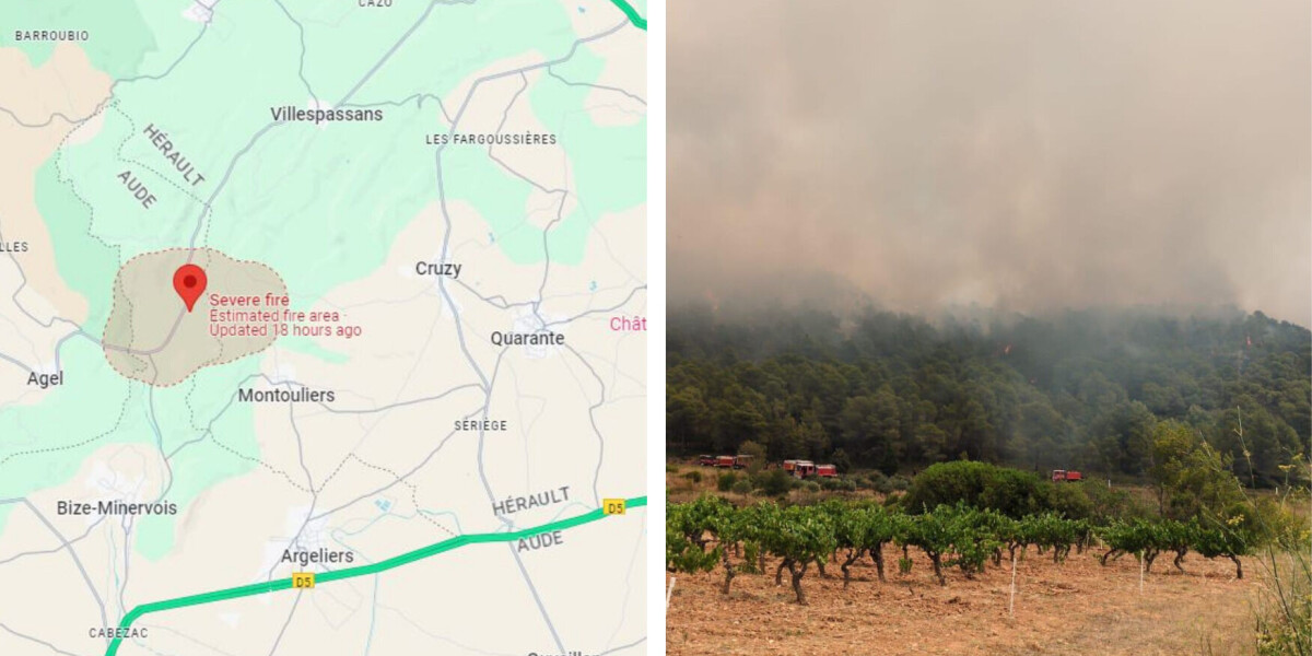
BLAZE TOOK SEVEN HOURS TO TACKLE AND AFFECTED TWO DEPARTMENTS A forest fire which broke out on the border of the Aude and Hérault departments yesterday (July 29) has destroyed more than 40
hectares of land. Around 330 firefighters were called to the blaze, which began in the commune of Montouliers (Hérault) and spread towards Bize-Minervois (Aude). Firefighters were assisted
by five aircraft (including a helicopter) based at the nearby Béziers-Cap d'Agde which dropped water onto the fire. The blaze first broke out in the afternoon at around 13:00. It was
successfully controlled by around 20:00. It is unknown what caused it, but the two departments are currently facing heatwave warnings as temperatures reach 40C in the area. Read more:
40.6C (in shade): French heatwave warnings expand to north Nearly 60 hectares of land was affected with 43 hectares of forest and field being completely destroyed. However, no homes were
damaged and nobody was injured. > 🚒🧑🚒 L’incendie de #Montouliers est circonscrit. > 👉 Le feu n’évolue plus grâce à la mobilisation de 330 > sapeurs-pompiers @PompiersHerault
@SDIS11OFFICIEL et des moyens > aériens nationaux @SecCivileFrance (3 Canadairs et 1 avion Dash). > Près de 55 Ha parcourus par le feu, dont 43… > pic.twitter.com/wHlFnisFue > —
Préfet de l'Hérault 🇫🇷 (@Prefet34) July 29, 2024 FOREST FIRE RISK REMAINS HIGH State weather forecaster Météo France provides a forest fire risk map, showing which departments are
more prone to see blazes starting due to effects including weather conditions and dryness of vegetation. Currently, three departments (Gard, Var, and Vaucluse) are facing heightened
tier-three orange warnings for forest fires, however Hérault and Aude are only on a tier-two yellow alert. You can see the map, which provides information for the next 48 hours, here. Read
more: How does France's wildfire risk forecast work? Where can I see it? Note that at departmental level prefects can enact additional restrictions and regulations, including limiting
access to certain forests and areas more prone to fires. This can also include the temporary banning of works (travaux) within certain communes bordering or in these areas. To find if there
are any restrictions in your department, you can google the name of your department plus ‘communiqués de presse’ to find a list of updates from the prefecture. Not all departments will
provide daily updates, and some may not have any specific warnings in place. Read more: Alert over fire risk in French forests as most blazes caused by people