- Select a language for the TTS:
- UK English Female
- UK English Male
- US English Female
- US English Male
- Australian Female
- Australian Male
- Language selected: (auto detect) - EN
Play all audios:
1. IMPROVING COMMUNITY ACCESS WINTER GARDEN, FLORIDA Located in a suburban area dominated by single-family housing, this Winter Garden roadway is an important connector for kids walking and
biking to school as well as for workers getting to their commuter routes. Vehicle congestion has increased as the surrounding areas have developed and commercial and retail establishments
have flourished. On one corner of the intersection is a municipal baseball park. The remaining three corners are slated for commercial development. Instead of widening the roadway and
intersection to allow for more vehicles at faster speeds, the community envisions a safer intersection that creates better access for everyone and attracts high-quality commercial
development. THE CHALLENGES * The intersection, which is a critical access point for schoolchildren, is becoming more congested with vehicular traffic as the area develops. * The speed limit
(40 mph on one of the approaches) is fast and dangerous. * Drivers take risks to get through the intersection before the light turns red. * Crashes have occurred, including one in which an
elementary school student riding a bicycle was hit by a left-turning car. An intersection in Winter Garden, Florida Photo by the WALC Institute THE POSSIBILITIES * A modern roundabout slows
vehicles to a safer speed while still moving traffic efficiently. Since such a roundabout also simplifies the intersection, it eliminates the conflicts created by left turns and makes
crossing easier for people who are walking or bicycling. * Adjacent landowners donate corner clips of their properties to allow for the roundabout, which will ultimately enhance property
values. * The bicycle lane allows a cyclist to use the roundabout as a car would or to exit the protected lane, dismount and cross the roundabout as a pedestrian. * Having made a quality
public investment into the area, quality private investment follows. An illustration of what the intersection could become. Photovision by the WALC Institute and TDC Design Studio 2.
CONNECTING A NEIGHBORHOOD FORT WORTH, TEXAS This Fort Worth road is both a commuter route and a primary access point for a residential neighborhood, a commercial area, an emerging arts
district and several schools. Violent crime is a notable problem in the area, and people, including children and senior citizens, are seen walking along and crossing the four-lane roadway,
which measures about 44 feet from curb to curb and carries more than 20,000 vehicles a day. THE CHALLENGES * A mixture of housing, churches, late-night establishments, schools, stores and
more creates a demand for safe places where people can cross. * Proper crossing areas are about a half-mile from one other, leading to pedestrians crossing mid-block in unmarked locations. *
The road is overly wide and fosters fast vehicle speeds. * Sidewalks are missing in some sections, are blocked by vehicles in others and in too many places are too near the edge of the
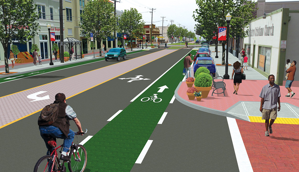
road. A roadway in Fort Worth, Texas Photo by the WALC Institute THE POSSIBILITIES * A road diet makes the street safer and more welcoming. * On-street parking, a bike lane and a colored
center-turn lane are added. * A modern roundabout slows vehicles to a safer speed while still moving traffic efficiently. Since such a roundabout also simplifies the intersection, it
eliminates the conflicts created by left turns and makes crossing easier for people who are walking or bicycling. * Curb extensions serve to (1) narrow the crossing distance for pedestrians,
(2) create a tighter and slower turn for vehicles entering the main street, and (3) provide spaces for parklets, street furniture and bike racks. * Pedestrian-scale lighting supports
walking and bicycling after dark. * Liner buildings convert previously unused parking lots into productive retail space that generates revenue and locates buildings where they help provide
security and "eyes on the street." * Covered bus shelters protect transit riders from the sun and rain. What the roadway could become. Photovision by the WALC Institute and TDC
Design Studio 3. PUTTING CROSSWALKS WHERE PEOPLE NEED THEM DETROIT, MICHIGAN A sprawling, car-focused corridor in Detroit feeds too-fast vehicle speeds and lacks a sense of place. Along the
corridor, land uses create mid-block "desire lines," or places where pedestrians want to cross the street to get from one destination to another. Indeed, many people routinely
cross mid-block in this area. Residents want and need active modes of transportation to access their daily destinations, including schools, stores and places of employment. THE CHALLENGES *
Long blocks create long distances between intersections and crosswalks. * With no mid-block crossings, pedestrians must either walk far out of their way to an intersection or take their
chances during a lull in the traffic. * Crosswalk markings are faded, making them difficult for drivers to see. * The roadway is overly wide, which leads to increased vehicle speeds and
makes the crossing distances long — and dangerous — for pedestrians. A sprawling corridor in Detroit. Photo by the WALC Institute THE POSSIBILITIES * The street remains a multilane arterial
roadway, except it now includes mid-block crossings with on-demand call buttons that allow pedestrians to activate a crossing signal. * Crosswalk markings are highly visible and at least 12
feet deep. * Vehicle lanes are 10 feet wide. * Bicycle lanes have been added and bicycle parking is placed at storefronts. * Shelter is provided at all transit stops. * The posted speed
limit is lowered to 30 mph. * Street parking is converted to head-out diagonal parking. * Mixed-use, in-fill development creates a destination. Property values rise. * This "Complete
Street" now offers transportation options. What the corridor could become. Photovision by the WALC Institute and TDC Design Studio 4. MAKING PARKING MORE PRODUCTIVE TUPELO, MISSISSIPPI
This area of Tupelo connects residents to prized schools, as well as to churches and local stores. Unfortunately, the emphasis on moving and storing vehicles has created an environment that
is hostile to pedestrians and bicyclists. Property values are diminished, and there's an overabundance of off-street parking and missed opportunities for providing on-street parking.
THE CHALLENGES * Sidewalks and other pedestrian infrastructure are completely missing on one side of the street, which forces pedestrians to either walk in the street or to cross the street
two times in order to reach their destination. * More "eyes on the street" and pedestrian-scaled lighting are needed. * Excess off-street parking is an inefficient and isolating
use of land. * The overly wide roadway encourages high vehicle speeds and forces pedestrians to cross long distances. A street in Tupelo, Mississippi Photo by the WALC Institute THE
POSSIBILITIES * The street is restored as a prime place for neighborhood living. * The large parking lot is redeveloped to become a true community asset. * On-street parking reduces the need
for off-street parking, which improves walking conditions by helping to calm traffic and create a buffer between vehicles and pedestrians. * The posted speed is lowered to 25 mph. * Where
the parking ends and the curb extension begins the crossing distance is narrower and easier for pedestrians. * A modern roundabout slows vehicles to a safer speed while still moving traffic
efficiently. Since such a roundabout also simplifies the intersection, it eliminates the conflicts created by left turns and makes crossing easier for people who are walking or bicycling. *
The placement of street trees, which also tend to reduce vehicle speeds, helps to create a buffer that protects pedestrians. What the street could become. Photovision by the WALC Institute
and TDC Design Studio 5. CELEBRATING AN ARTS HERITAGE EXMORE, VIRGINIA This artisans' town features a historic Main Street and is home to one of the largest employers in the county — a
manufacturer of mosaic tiles. The town has chosen to invest in revitalizing its downtown and celebrating its arts heritage. However, this uninviting intersection is located just one block
off Exmore's Main Street, making the connection into the downtown neighborhood both placeless and unsupportive of pedestrians and bicyclists. THE CHALLENGES * No sidewalks or marked
crossings are provided. * The buildings turn their stark and windowless backs onto the street. * Street corners have wide turning radii that allow vehicles to take the turns at fast speeds.
* Trees are missing and overhead utility wires are unsightly. An intersection in Exmore, Virginia Photo by the WALC Institute THE POSSIBILITIES * A neighborhood pocket park featuring a
mural wall and mosaic blossoms better celebrates the community's connection to art. * The intersection is calmer, with better support for pedestrians and cyclists. * Vacant buildings
are transformed into studios. * A raised mini-circle is decorative and slows traffic. * Freight trucks have room enough to maneuver and load and off-load materials. What the intersection
could become. Photovision by the WALC Institute and TDC Design Studio 6. REPAIRING A DEADLY STREET ATLANTIC CITY, NEW JERSEY This Atlantic City thoroughfare is a major transportation route
used by pedestrians, bicyclists, drivers and public-transit users, yet it's sorely deficient in basic infrastructure and amenities. A shopping mall generates trips to and on the street,
but the corridor prioritizes vehicle mobility over multimodal accessibility. The area is characterized by vast expanses of asphalt with high maintenance costs. Sadly, the corridor takes
lives. The roadway is the county's most deadly street for pedestrians. There are no quick fixes here, but the area has the potential to become a prosperous village. THE CHALLENGES *
Wide roads and large intersections encourage vehicle speeds even faster than the posted 50 mph speed limit. * The overly wide road increases the distance pedestrians must cross. * Buildings
set back and separated from the street by underutilized parking lots force people to walk even greater distances once they're off the street. * Sidewalks are absent in many locations. *
Crosswalks are not marked and pedestrian signals do not exist. * The lack of pedestrian and bicycle infrastructure, accessible transit stops and traffic-calming measures deter walking and
bicycling, which increases automobile dependency for even short trips and, therefore, congestion. An Atlantic City roadway Photo by the WALC Institute THE POSSIBILITIES * The thoroughfare
remains a multilane arterial roadway, but it now includes a frontage road with street parking, a safe and highly visible crosswalk and crossing island, a wide bike lane and covered transit
stop. * Mixed-use infill development is built to pedestrian scale. * Adjacent land values are increased and the mall becomes a destination. What the roadway could become. Photovision by the
WALC Institute and TDC Design Studio _EDITOR'S NOTE: The Imagining Livability Design Collection was published in Spring 2015 by AARP Livable Communities and the WALC (Walkable and
Livable Communities) Institute. The institute has since closed shop, but the 40-page publication it helped develop remains a valuable resource for communities and local leaders._ More from
AARP.org/Livable Use the dropdown to choose a livability topic. Select a Subject