- Select a language for the TTS:
- UK English Female
- UK English Male
- US English Female
- US English Male
- Australian Female
- Australian Male
- Language selected: (auto detect) - EN
Play all audios:
Carol Goodman lives in a 55-and-older community just three-tenths of a mile from two shopping centers. However, she and most of her neighbors drove to the development's restaurants,
businesses, medical offices, shops and supermarket. Although the mixed-use community in Edgewater, Maryland, was created using many components of walkable, urban design — the community has
sidewalks, recreational spaces and varied housing types — the developer bisected the residential neighborhood from the commercial section with a wide thoroughfare. WHEN PEOPLE TRIED TO CROSS
FROM THE RESIDENTIAL TO THE RETAIL AREAS ON FOOT, THEY NEEDED TO CROSS ALL FOUR LANES OF TRAFFIC WITH CARS COMING, SOMETIMES DANGEROUSLY FAST, FROM BOTH DIRECTIONS. Nearly two-decades after
the first homes broke ground residents launched efforts to make their neighborhood more pedestrian-friendly by getting a crosswalk island installed. THE PROBLEM The "Townes"
section of the planned community contains nearly 400 dwellings located in distinct clusters of townhomes, single-story villas and condominium apartment buildings. Roughly 200 of the
residential units are designated as senior (55-plus) housing. Mitchells Chance Road runs approximately a half-mile in length from end to end and receives traffic from a busy state highway.
The posted speed limit is 30 mph. However, according to a traffic survey by county officials, the actual average speed along the route is 43 mph. Many residents of the Townes want to walk to
the restaurants and stores across the street. Retailers everywhere want people to shop locally. Once residents get into their cars, they can easily bypass the closest stores and shop
further afield. SEEKING A SOLUTION Carol Goodman attempted to bring the issue to her neighborhood council, but she didn't get far. "Nobody championed it," she explains. The
effort got the jumpstart it needed when she found Carla DeWitt, a determined neighbor and community board member. DeWitt describes herself as tenacious. She took a special interest in the
project because her parents had decided to move from New York to Maryland to be nearer to their only child, son-in-law and grandson. "My mother is a city girl. She's accustomed to
walking places. My parents like this neighborhood because it's within walking distances to shops and medical offices," DeWitt said. At the time, she had been dealing with someone
from the Maryland State Highway Department on a different issue, so she asked him who to contact about resolving the public safety issue on Mitchells Chance, which is a county road. After a
few emails in search of the right person, DeWitt reached Nestor Flores, a civil engineer in the traffic engineering department of the Anne Arundel County Department of Public Works (DPW).
FINDING THE PROBLEM SOLVER Flores notes that the initial contacts from residents focused on placing a traffic signal at the intersection. He explained he needed to conduct a traffic survey
before they could talk about a traffic light or any other potential solutions. Those conversations took place in July 2016. Flores said he would start the survey right after the area's
public schools opened in late August so he could get a more accurate traffic count. When the county conducts a traffic study or survey, it's looking for a count of cars and pedestrians.
If a roadway is used by a steady number of vehicles, the intersection might be a candidate for a traffic light. If there aren't enough cars to go with a signal, other traffic calming
tools are used. To conduct the study, the county placed a rubber strip on the roadway for several days. Each time a car ran over the strip, it was counted. DPW also mounted a camera on a
nearby pole to watch pedestrian interactions for the day. "As soon as I saw that rubber strip, I sent Nestor a thank you email," DeWitt said. "I feel it's always nice to
acknowledge people — even when they're simply doing their job." The acknowledgment also let Flores know that DeWitt was paying attention and would be there to follow-through at
each step in the process. He agrees that DeWitt’s ongoing interest in the project was an asset. "Carla was good about keeping up," Flores says. "I told her early on that
it's not going to hurt my feelings if she keeps calling and emailing. It lets me know that there's still an interest in the project and it makes it easier to schedule things and
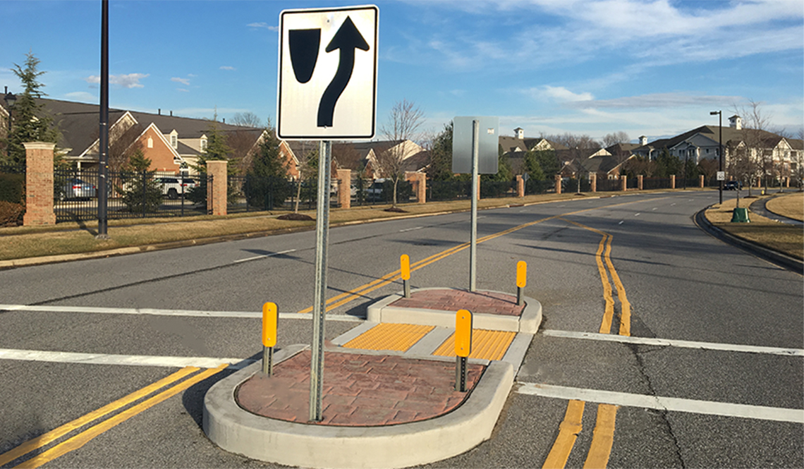
know we're allocating the proper assets." DURING: A temporary pedestrian island was installed in June 2017. Image from Google Maps FINDING A SOLUTION The survey results: 6,000 cars
and 26 pedestrians used the intersection each day. Data about excessive speeds along the route were delivered to the local police. While the traffic counts didn't meet the threshold
for a red-yellow-green traffic signal (they’d need more than double the volume to meet state guidelines), the results indicated that the intersection was in need of a safer alternative for
pedestrians. (Read about a community that did succeed in having a traffic light installed.) Flores worked with DeWitt to share the ideas with residents by organizing a public community
meeting. To gather an audience, DeWitt hung flyers on community bulletin boards and emailed residents. At the meeting, Flores presented two options: One would create an island in the median,
giving pedestrians a safe resting place while crossing. The other option would take the road from four lanes to two with a wide, multidirectional lane running down the center. After the
meeting, DeWitt and Flores sent homeowners a link to an online survey and encouraged them to submit comments directly to Flores. All who completed the survey did so in support of Option 1.
The crosswalk and pedestrian island would be placed across a narrow section of the roadway, just off the intersection itself. Two days before Christmas in 2016, DeWitt got word from the
county that the project was approved. A temporary pedestrian island (see the photo above) was installed in June 2017. The permanent island (shown below) was installed that fall. The
Department of Public Works was able to do this without having to ask the County Council for special expenditures because the county includes routine spending for public safety in the DPW
budget. “We have capital funding for these kinds of neighborhood traffic control devices. This cost around $10,000 to $15,000 to complete,” Flores said. AND DONE! The permanent island gives
pedestrians a safe place to stand when they can't cross all four lanes at once. Future enhancements may bring sensor-operated flashing lights to alert drivers that a pedestrian has
entered the intersection. Photo by Melissa Stanton THE HURDLES Knowing the jurisdictional differences between federal, state, county and municipal roadways and officials is key. The local
police department can help identify which roads belong to which jurisdiction. Next up is to reach the right department within the government agency, and then the right person. This is when
tenacity pays off, says DeWitt: "Don't give up. Keep calling, keep emailing, keep trying." Funding could have been a hurdle for this project but the county had money in place
for intersections that threaten public safety. If a more extensive and expensive fix was required, DeWitt and Goodman might have needed to seek the help of their elected county council
member to get money set aside in the next budget cycle. Flores notes the importance of monitoring the project after it's been installed: "This isn't a silver bullet. We
install it and, if needed, keep tweaking as we go along." At the state level, "complete streets" legislation has been introduced to help ensure that when a road is built or
refurbished in Maryland, planners consider the needs of all users. While such a policy wouldn't call for the installation of pedestrian features on, say, an expressway, it would have
ensured that Mitchells Chance Road was safely crossable. To see which states and municipalities have implemented Complete Streets (also called Safe Steets) policies, visit the National
Complete Streets Coalition. THE PROCESS Anne Arundel County's "Neighborhood Traffic Control Guidelines" recommend these steps for how communities and traffic engineers can
work together to address road safety needs. 1. Define the problem(s) 2. Document the problem(s) 3. Define the desired result(s) 4. Define the constraints(s) 5. Develop options 6. Decide on a
plan 7. Develop community consent 8. Do it (aka: implement the plan) 9. Document the results (and make modifications if needed) _Mitchelle Stephenson is a freelance writer based in Anne
Arundel County, Maryland._ _Published February 2018_ RELATED